
Guide Home Maps Hiways SEPTA Info Hotels INTRO Railroad Sights Links Photos
Introduction
I can't figure it out, I asked the guys on one of the Philly railfanning groups for help, and no-one spoke up. I guess Philadelphia doesn't have any resident railfans :-) So for now, I guess I'll have to go it alone, and if there are mistakes, hopefully, someone out there will email me and let me know.
Like Baltimore, there is definite lack of good railfan info for the area. And, if it does exist, where do you go to find it? There are a few places you can go on the internet, but there's no consistency, and many go as quickly as they come (just like mine could!).
To further complicate railfanning in
Philadelphia, many places are referred to by their "CP" names, and without a
real good map that concentrates on the tracks of Philly, it's very hard to
decipher where these places are. Even with the few railfan websites I have
found for Philly, their descriptions are sometimes confusing, especially if
you're trying to figure things out around ZOO! So, what to do?
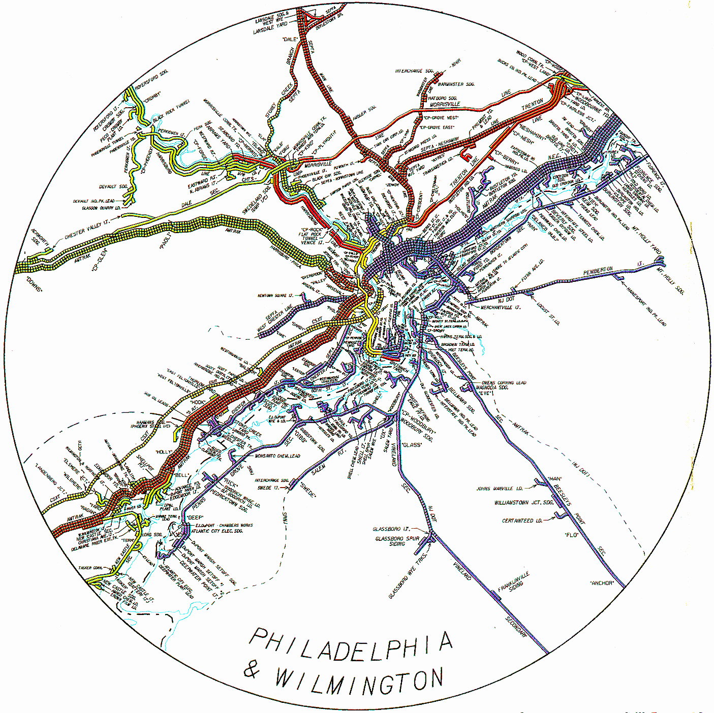
The Conrail map of
the Philadelphia area (below) is a good start, but the information needs to be overlaid
on a decent road map so you know where things are. The Philadelphia area used to offer the railfan a
plethora of railroad signal types: Colorlights, Position Lights, Position Color
Lights, and Color Position Lights. Quickly: The B&O CPL's are now long
gone in most places, maybe a dwarf or two might still exist somewhere, but I'm
sure most of them were taken out for someone's personal collection! :-)
The Pennsy all yellow PL's are still around on former PRR SEPTA lines, but are
otherwise gone. The former Reading lines still use the "tri-light" Style
colorlight signals. And Amtrak uses a combination of their colorized PL
signals, usually referred to as PCL's (position color light). Amtrak uses modified signals of the
former Pennsylvania RR, position light signals (PL's), on the North East Corridor,
which is shared by SEPTA on the Southside of Philly, and NJT on the Northside.
In the terminal area's like 30th Street station, you can still find dwarf PL's
and Pedestals (double dwarf PL's). CPL signals proliferate on CSX's lines that once
belonged to the B&O, up to the CP Gray area. We have to be careful here
tho, because CSX has started replacing them as they have in other areas, like
Baltimore. One place that is easy to see this is along I95 coming up from
Wilmington where the tracks parallel the highway for a bit. Also of note,
is a set of pedestrian crossing gates using semaphore motors on the B&O in
Darby, where a set of streetcar tracks also cross.... fun place for photos! Of course, the real winners around Philadelphia
are the Position Light signals of the former Pennsylvania RR, because this is
where it all started for them. ZOO still has quite a few of them, and they
can be still found on a lot of the SEPTA lines coming in and out of 30th Street
Station on former PRR lines. Pedestal and dwarf versions can easily be
found too. In addition, there are numerous places where you
can get colorlight and "tri-light" signals in your shots. Signal purists
like to call them colorlight signals. Tri-light signals are where the
lenses are arranged in a triangular fashion.... good spots for them is on the Norristown SEPTA
line, and generally most of the northern routes that used to be Reading lines. I know the Reading (and Lehigh Valley) used
searchlight signals, and there are supposed be some on the ex RDG tracks between
Philadelphia-Reading and Philadelphia-Allentown, but I'm not sure if there are
any in the immediate area. There may also be some where Penn Central
re-signaled, for that's what they used in new projects. Anyone want to
help out here? Resources - Don't leave home
without them!..... Here's a few things I recommend you
take along and don't generally leave home without..... -- Maps..... See the next section. -- The American Shortline Railway Guide by Edward
A. Lewis (Kalmbach). -- If you carry along a scanner, try to find out
the local railroad freqs ahead of time unless you have a scanner that scans
really, really fast so you don't miss a call. In these post 9/11 days, there
is much pro and con discussion concerning the relative merits of being perceived
as a terrorist threat if you have a scanner. Add to that, that some states
have laws preventing you from having portable scanners, such as Michigan and New
Jersey. If you are a ham, one option available to you is to buy a
two-meter HT that also covers the Hi-VHF band. I was lucky with two cops
at the Plymouth Diamond in suburban Detroit.... they just threw my scanner into
the trunk and let me off with a warning. -- If you belong to AAA, they have pretty good
guide books available with hotel info and other sights, altho the hotel
information is limited to the ones they consider halfway worthwhile - rare is a
listing for Motel 6. -- Check Chamber of
Commerce websites for hotel and motel info. -- If you are going to be in Commuter Railroad or
transit company territory, be sure to check their websites for information,
photo policies, maps, and schedules. Maps - Don't leave home without
them either..... -- If you do a lot of traveling, I definitely
recommend joining the AAA. They are an excellent source of "free" maps
once you join (10 maps and you got your money back). Almost every map I've
obtained from them (so far) has had the railroads on ‘em, and some of them even
have yard names (Portland OR and Indianapolis IN for instance). With all
the traveling I do, I find the $35 a year well worth the investment, if for
nothing more than their maps. A large number of the local offices usually
have the more obscure local maps available at no cost -- some are AAA maps, some
are locally printed maps..... Even with the AAA, you still have to be
careful, because they do distribute a few bummers as maps for the metro Boston,
New York City and Philadelphia areas - they don't contain enough detail and they
don't have any railroads on them. -- For the Philadelphia area, I recommend the series
of county map books put out by ADC (Alexandria Drafting Co). They can be found
everywhere: 7-11s, Giant food stores, drug stores, etc. While I DO endorse their series of county map books,
I DO NOT endorse their series of state map books - they
lack railroad info. --
Franklin puts
out an excellent Metro Philadelphia street map book.... They're about
$10-15 at most bookstores and some gas station/convenience stores in the area. -- APB (Alfred B Patten) puts out a decent series
of maps for the eastern PA area. -- Geographica does the same for NJ and lower
NY. -- I haven't been too impressed with the maps
from DeLorme, so far. -- Be careful with other
maps. One I purchased recently for a city in Iowa, had the
Wabash and all of the other 60's era railroad names on it. While this is
nice for historical purposes, the other data on the map may not be current,
either. Some maps don't have railroads on them at all, so check em
out before you buy em. In Defense Of
Myself..... It's my website, it's that simple,
so I won't bore you with the details, I'm sure ya'll have a hankerin for what I'm going to
say. So OK, What about the other
things to see around Philadelphia besides railroad stuff..... Links for non-railroad attractions in the immediate
Philadelphia area: Independence Hall The Liberty Bell The Benjamin Franklin Institute: The Philadelphia Zoo: The Philadelphia Museum of Art: University of Pennsylvania Museum of Archaeology and
Anthropology -
3260 South St,
Philadelphia, PA
- (215) 898-4000 Franklin Square: The United States Mint -
151 North Independence Mall E,
Philadelphia, PA
- (215) 408-0114 Penn's Landing -
121 N Columbus Blvd,
Philadelphia, PA
- (215) 629-3200 The Mummers Museum -
1100 S
2nd St, Philadelphia,
PA -
(215) 336-3050 For a boat load of sites, check out the
A View On Cities website at:
http://www.aviewoncities.com/philadelphia/philadelphiaattractions.htm
Signals
-- An
Amtrak timetable, unless you're railfanning a line not serviced by them (I still
bring em along anyway).
-- Steam Productions has a series of regional map
books.... While they are good railroad map books, as they contain a lot of
railroad route and yard info, they don't have any road or highway info on the
maps. This makes them very difficult, if not impossible, to get around
with them alone. Careful coordination with a regular map is
necessary.
-- IF you make it to a SEPTA store, they offer two maps. One is a city
map, the other map covers their suburban routes. Other places also carry
these maps. THEY ARE an invaluable aide if railfanning in Philadelphia.
They do not however, have the railroads on them if they don't carry commuter
trains, darn it.
www.philadelphiazoo.org
www.philamuseum.org
www.museum.upenn.edu
www.historicphiladelphia.org
http://www.usmint.gov/index.cfm?flash=yes
Washington Square -
210 W Washington Square,
Philadelphia, PA
- (215) 592-7787
No website available
Disclaimers:
I love trains, and I love signals. I am not an expert. My webpages reflect what I find on the topic of the page. This is something I have fun with while
trying to help others.
Please Note: Since the main focus of my two websites is railroad signals, the railfan guides are oriented towards the signal fan being able to locate them.
For those of you into the modeling aspect of our hobby, my
indexa page has a list of almost everything railroad oriented
I can think of to provide you with at least a few pictures to help you detail your pike.
If this is a railfan page, every effort has been made to make sure that the information contained on this map and in this railfan guide is correct. Once in a while,
an error may creep in :-)
My philosophy: Pictures and maps are worth a thousand words, especially for railfanning. Text descriptions only get you so far, especially if you get lost or
disoriented. Take along good maps.... a GPS is OK to get somewhere, but maps are still better if you get lost! I belong to AAA, which allows you to get
local maps for free when you visit the local branches. ADC puts out a nice series of county maps for the Washington DC area, but their state maps do not have the
railroads on them. If you can find em, I like the National Geographic map book of the U.S..... good, clear, and concise graphics, and they do a really good job
of showing you where tourist type attractions are, although they too lack the railroads. Other notes about specific areas will show up on that page if known.
Aerial shots were taken from either Google or Bing Maps as noted. Screen captures are made
with Snagit, a Techsmith product... a great tool if you have never used it!
By the way, floobydust is a term I picked up 30-40 years ago from a National Semiconductor data book, and means miscellaneous
and/or other stuff.
Pictures and additional information is always needed if anyone feels inclined to take 'em, send 'em, and share 'em, or if you have something to add or correct.... credit
is always given! Please be NICE!!! Contact info is here
Beware: If used as a source, ANYTHING from Wikipedia must be treated as being possibly being inaccurate, wrong, or not true.
SEPTA HOMEPAGE
RAILFAN GUIDES HOME
RAILROAD SIGNALS HOME
NEW DEC19/2009,
MAY18/2012
Last Modified
01-Oct-2019