In General
Getting Here
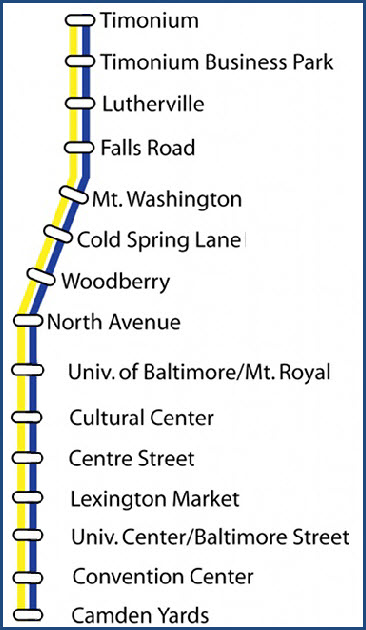
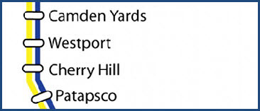
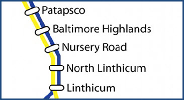
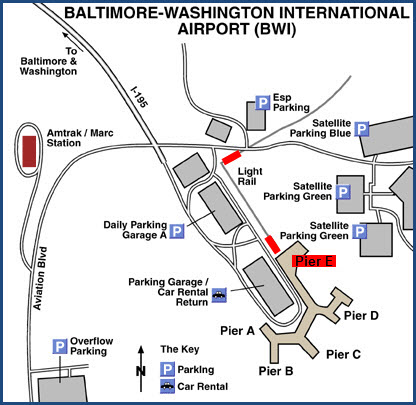
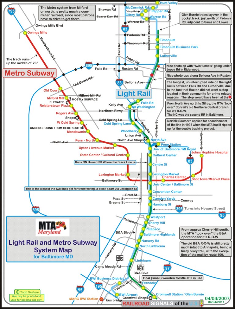
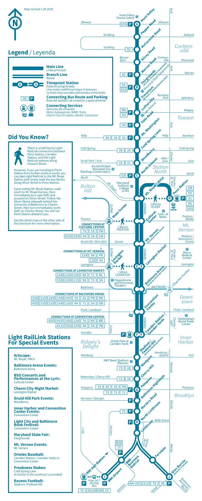
Map
The LRV's
Pictures
Signals
Floobydust
RAILROAD SIGNALS HOME
Location / Name:
Baltimore City MD
What's Here:
Baltimore Light Rail System, among other stuff
Data:
GPS Coordinates: as needed
Phone A/C: 410/443
ZIP: 21201 (downtown Baltimore)
Access by train/transit:
MARC Commuter Rail at Camden Station
MARC and Amtrak at Penn Station
Airplane service at BWI Airport
The Scoop:
According to Wikipedia, the light rail system had its origins in a plan drawn up in 1966, only 3 years after streetcars disappeared from the streets of Baltimore City.
By 1983, the only thing that had been built is the Metro Subway that opened from Charles St to Reisterstown Road Plaza.
The plan to open a light rail system got a push in the late 80's by Governor William Donald Schaefer (also a former mayor of Baltimore), who wanted to have a rail transit system opened in time to coincide with the opening of a new Oriole's Baseball stadium being built at Camden Yards. In order to expedite the construction of the system, he decided that the state would bankroll the project on it's own, without federal funding, which allowed them to sidestep the the whole painful environmental review process.
Station placement and design were intended to be flexible and change over time, as stations could be built or closed at low cost. However, they were at times dictated by politics rather planning: proposed stops in Ruxton, Riderwood, and Village of Cross Keys were not built due to local opposition, while nearly-cut Mt. Royal and Timonium Business Park stations were built because the University of Baltimore and a local business group funded them. The Falls Road station was built with less parking than ridership required because of community requests and a fence, erected in response to a homeowner objecting to the visual impact of the station which prevented riders from accessing a nearby commercial building on the north side of the tracks.
Two things that irked me about the original design: One, they placed the catenary support poles on the "outside" of the right-of-way, thus requiring twice as many poles to be installed, costing us MORE (and taking up more real estate), and two, they didn't look into the future enough to take into consideration the eventual second track, and made the original R-O-W as if it was only ever going to be a single track line, requiring a complete tear-up of the R-O-W to install the second track and re-lay the first.
The Baltimore Light Rail System opened in stages over a 14-month period.
The initial segment from Timonium to Camden Yards opened for limited service for Orioles baseball games on April 2, 1992. The system opened for full service on May 17, 1992.
A three-station extension to Patapsco opened on August 20, 1992.
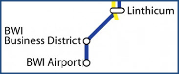
That was followed by a four station extension to Linthicum on April 2, 1993.
And finally, an additional two station extension to Glen Burnie opened on May 20, 1993.
Three extensions to the system were added in 1997. On September 9, the line was extended north 4.5 miles (7.2 km) to Hunt Valley, adding five stations that serve Hunt Valley Industrial Park and the Hunt Valley Mall, with the line ending on the property of the mall.
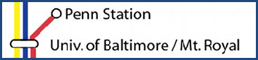
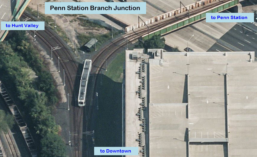
On December 6, two short but important branches were added to the system: a 0.3-mile (0.48 km) spur in Baltimore that provides a link to Penn Station for Amtrak's intercity trains and MARC local commuter service.
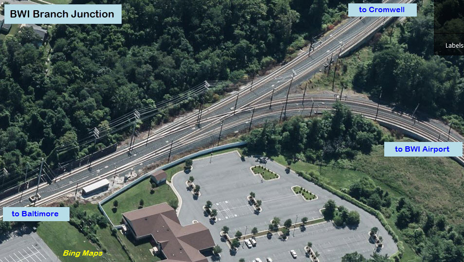
The second extension is a 2.7-mile (4.3 km) spur to Terminal E of BWI Airport, breaking off from the mainline just south of Camp Meade Rd.
Here is the rest of what I have on the Baltimore Light Rail System:
The North Avenue and Cromwell Shop Facilities
Signals of the Baltimore Light Rail System
Operating Rules of the Baltimore Light Rail System
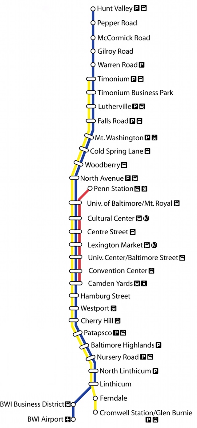
Stations of the Baltimore Light Rail System
- Hunt Valley to Lutherville
- Lutherville to North Avenue
- North Avenue to Westport
- Westport to Cromwell
- Penn Station & BWI
Misc Early Pictures of the Baltimore Light Rail System
Support Equipment for the Baltimore Light Rail System
- Signs
- Poles and Catenary
- Substations
- Track & Switches
How the Baltimore LRV's Work (Techincal Discussion)
Problems With the Baltimore Light Rail System (Editorial/bad language)
Acknowledgements:
Denver Todd
David Wilson/via Wikipedia
Google Maps
Bing Maps
Websites and other additional information sources of interest for the area:
https://en.wikipedia.org/wiki/Baltimore_Light_RailLink
For stations in the downtown area:
Coming up from Washington DC, Virginia, and further south - I-95 to I-395 into downtown Baltimore, or parallel route the Baltimore-Washington Parkway all the way into downtown Baltimore, and then taking a right turn onto Pratt St (after you pass the two stadiums), which will soon cross the Light Rail.
Coming "down" from Philadelphia PA, Wilmington DE, New Jersey, etc - I-95 south, thru the Ft McHenry Tunnel to I-395 into downtown Baltimore.
Coming "down" from Harrisburg, York, Scranton PA, Syracuse/Albany NY - I-81 to Harrisburg and then I-83 into downtown Baltimore.
Coming from the "west" as in Hagerstown/Frederick/Cumberland MD and I-70 at Breezewood - use I-70 to the I-695 Beltway south to I-95 into Baltimore.
For stations on the north end of the system:
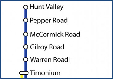
Take the Baltimore Beltway, I-695, around to I-83 and go north, take any of the exits Timonium Rd (x16), Padonia Rd (x17), Warren Rd (x18) , or Shawan Rd (x20).
For the Falls Road and Mt Washington Stations, take the exit for Falls Road (x23), and find your way to Falls Road and head south. Falls Rd heading south intersects "the end of 83" at Joppa Rd.
For stations on the south end of the system:
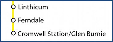
Take the Baltimore Beltway (I-695) to I-97 south (x5), and get off at exit 16, MD 648/B&A Blvd (Baltimore & Annapolis Blvd), and head south to the Cromwell station, or north to the Ferndale station.
For the Linthicum, North Linthicum, Nursery Rd, and Baltimore Highlands stations, use exit 6 from the Baltimore Beltway I-695. Go south on Camp Meade Rd for the Linthicum station, or north for the other three, taking a left onto B&A Blvd to reach Nursery Rd and Baltimore Highlands.
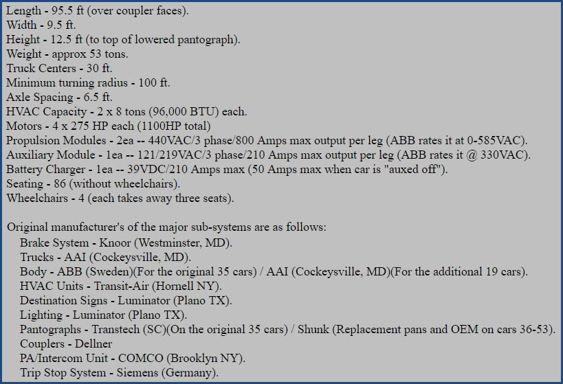
The Baltimore System has a collection of 53 cars, numbered in the 50xx series. 5001 thru 5035 are the original cars of he system, having been delivered in the 1991/1992 timeframe while work was being completed on the core system between Camden and Timonium.
Cars 5036-5053 were delivered in 1997.
Please note: Despite what the Wikipedia page says that the second batch of cars were built by AAI in Cockeysville MD, they WERE NOT. AAI built the trucks and the shells. The cars were built/assembled in Corning NY by ABB / ADtranz, same as the first batch. I have pictures of the second batch being built in Corning somewhere....
The cars were assembled in Corning to meet the requirement of having 51% of their content from the United States. There is a mix of Metric and SAE parts on both sets of cars as a result of this.
The Baltimore LRV's were the first in the United States to utilize AC propulsion instead of the more traditional DC traction motors. In addition to being more efficient, it is also a boon for those in maintenance, because DC motors (like the ones used on the Metro Subway cars), require periodic replacement of the brushes, and require ventilation ports on the motors, allowing the carbon dust to escape, creating a layer of black soot on everything. The AC motors used in the LRV's are permanently sealed, and hardly ever need to be opened. Because of this, ET's from the "heavy rail side" coming to the light rail shops for the first time are amazed to see how clean the place was!
The Baltimore cars were also the widest LRV's around at 9.5 feet wide, I don't know if they still hold that title or not.
If you want to find out how the various systems on the LRV's work, check out my technical section at: https://railroadsignals.us/lrvtech/lrvchap1.htm . Keep in mind tho, that this description is only good for the cars as originally delivered. The cars in their mid-life upgrade have been completely re-fitted with all sorts of new electronic contraptions! Here are the basic specifications and details of the cars from my technical pages:
The only other LRV's in the United States built by ABB are the "single car" LRV's of the Norristown High Speed line of SEPTA.... They may not look the same, but electrically, they are almost identical. In fact, with the modernization program going on in the late 2010's and early 2020's, the propulsion and auxiliary modules are being sent to SEPTA as replacements and back-ups for their cars.
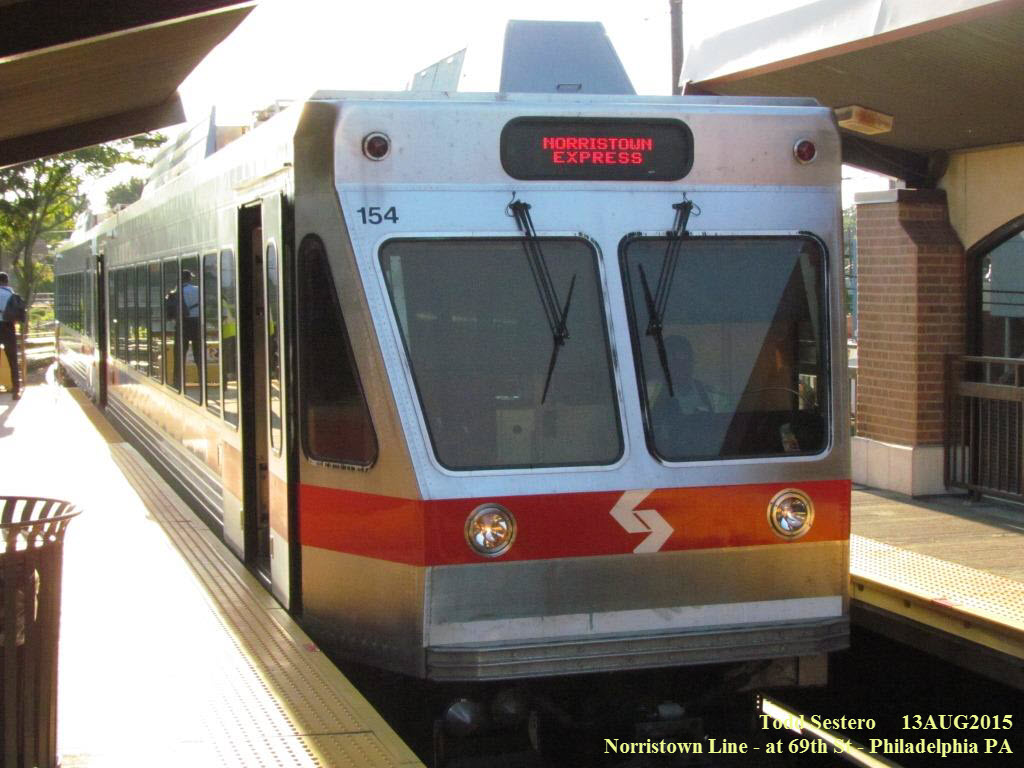 Norristown HSL LRV for comparison
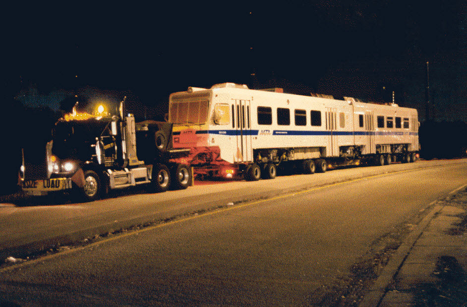
Here is a picture of #5036, the night it was delivered sitting on Road A - The "95's" (MTA police) didn't take kindly to me taking pictures of it for some unknown reason, even tho I had my uniform on, and my ID with me.... go figure.
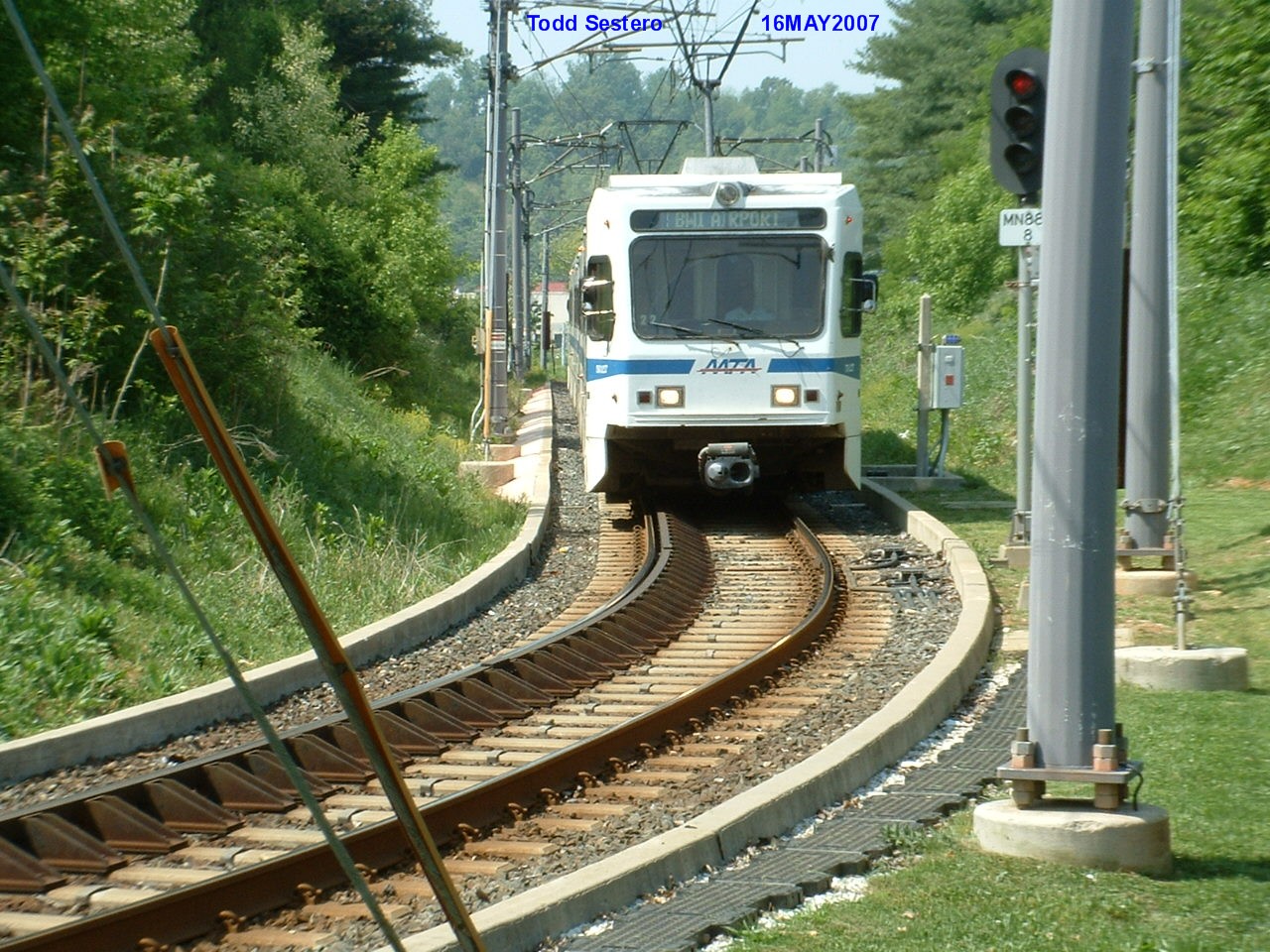 Coming up from Shawan Rd in Hunt Valley
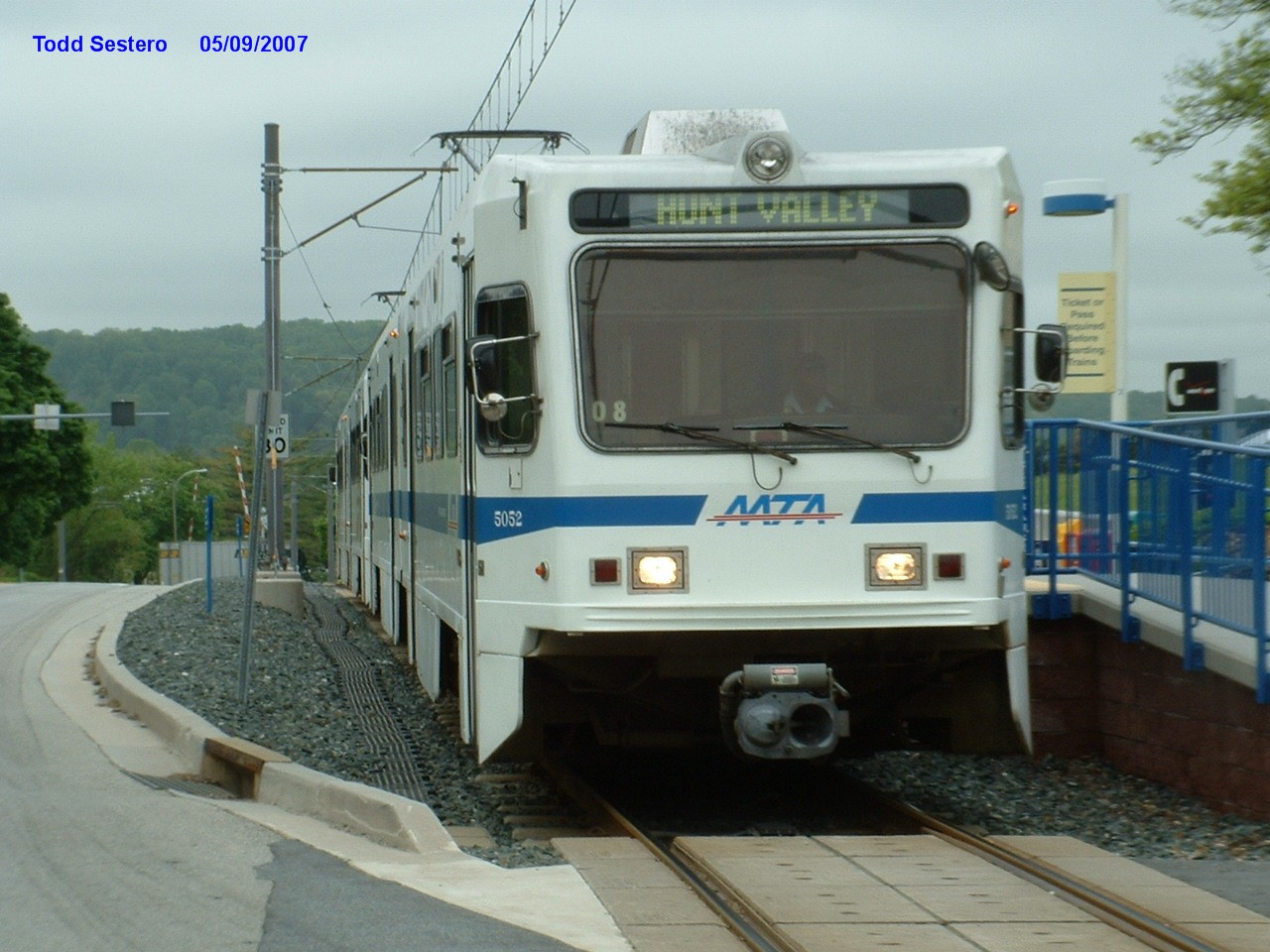 NB train at the McCormick station
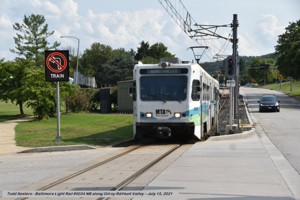 NB on Gilroy in Hunt Valley
I now have a whole section on the signals of the system here.
None for now......
Disclaimers:
I love trains, and I love signals. I am not an expert. My webpages reflect what I find on the topic of the page. This is something I have fun with while trying to help others.
Please Note: Since the main focus of my two websites is railroad signals, the railfan guides are oriented towards the signal fan being able to locate them. For those of you into the modeling aspect of our hobby, my indexa page has a list of almost everything railroad oriented I can think of to provide you with at least a few pictures to help you detail your pike.
If this is a railfan page, every effort has been made to make sure that the information contained on this map and in this railfan guide is correct. Once in a while, an error may creep in :-)
My philosophy: Pictures and maps are worth a thousand words, especially for railfanning. Text descriptions only get you so far, especially if you get lost or disoriented. Take along good maps.... a GPS is OK to get somewhere, but maps are still better if you get lost! I belong to AAA, which allows you to get local maps for free when you visit the local branches. ADC puts out a nice series of county maps for the Washington DC area, but their state maps do not have the railroads on them. If you can find em, I like the National Geographic map book of the U.S..... good, clear, and concise graphics, and they do a really good job of showing you where tourist type attractions are, although they too lack the railroads. Other notes about specific areas will show up on that page if known.
Aerial shots were taken from either Google or Bing Maps as noted. Screen captures are made with Snagit, a Techsmith product... a great tool if you have never used it!
By the way, floobydust is a term I picked up 30-40 years ago from a National Semiconductor data book, and means miscellaneous and/or other stuff.
Pictures and additional information is always needed if anyone feels inclined to take 'em, send 'em, and share 'em, or if you have something to add or correct.... credit is always given! Please be NICE!!! Contact info is here
Beware: If used as a source, ANYTHING from Wikipedia must be treated as being possibly inaccurate, wrong, or not true.
RAILFAN GUIDES HOME
RAILROAD SIGNALS HOME
NEW JUL31/2021, AUG04/2021
Last Modified 04-Aug-2021