In General
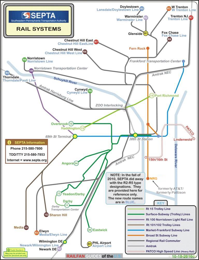
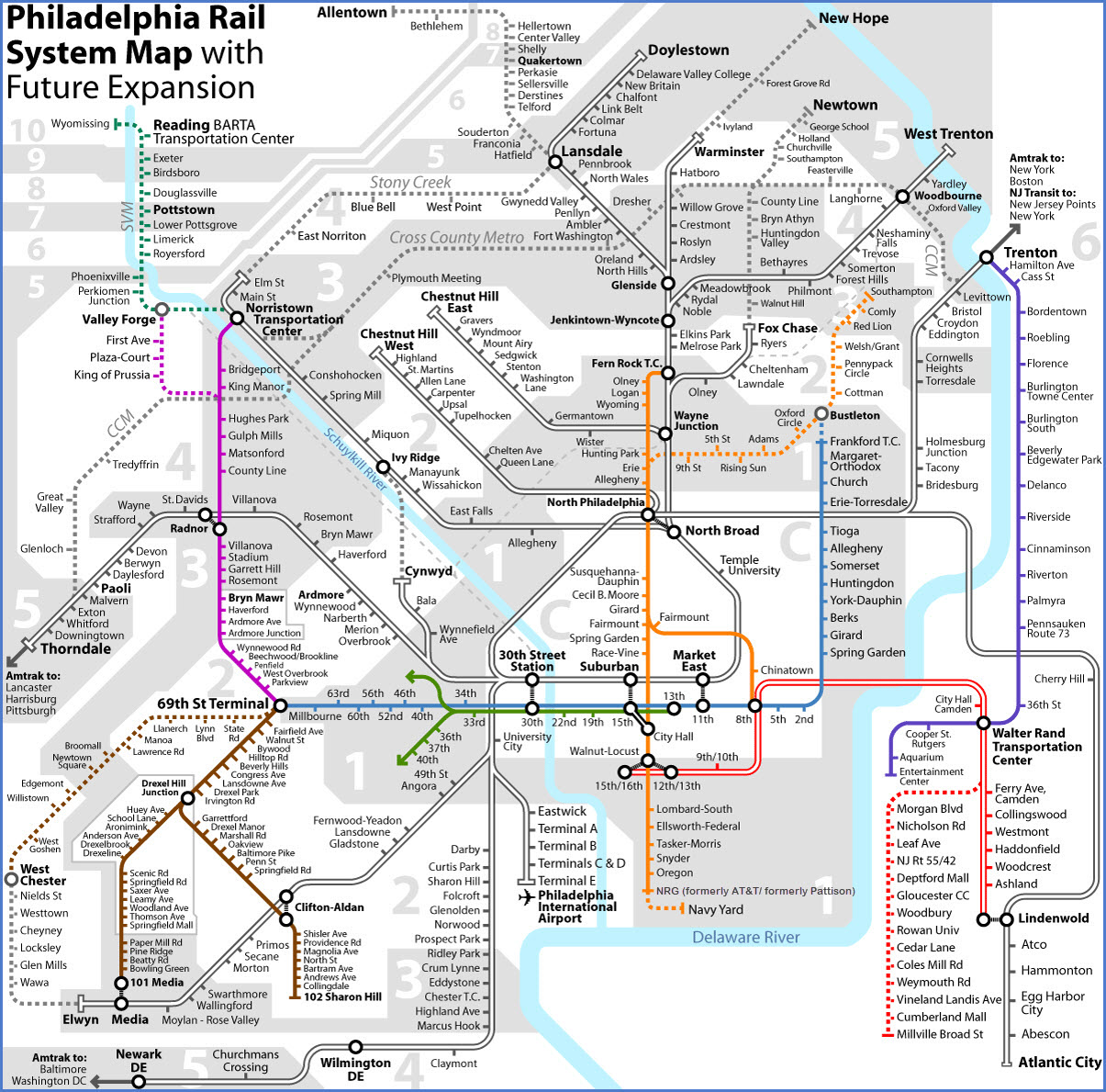
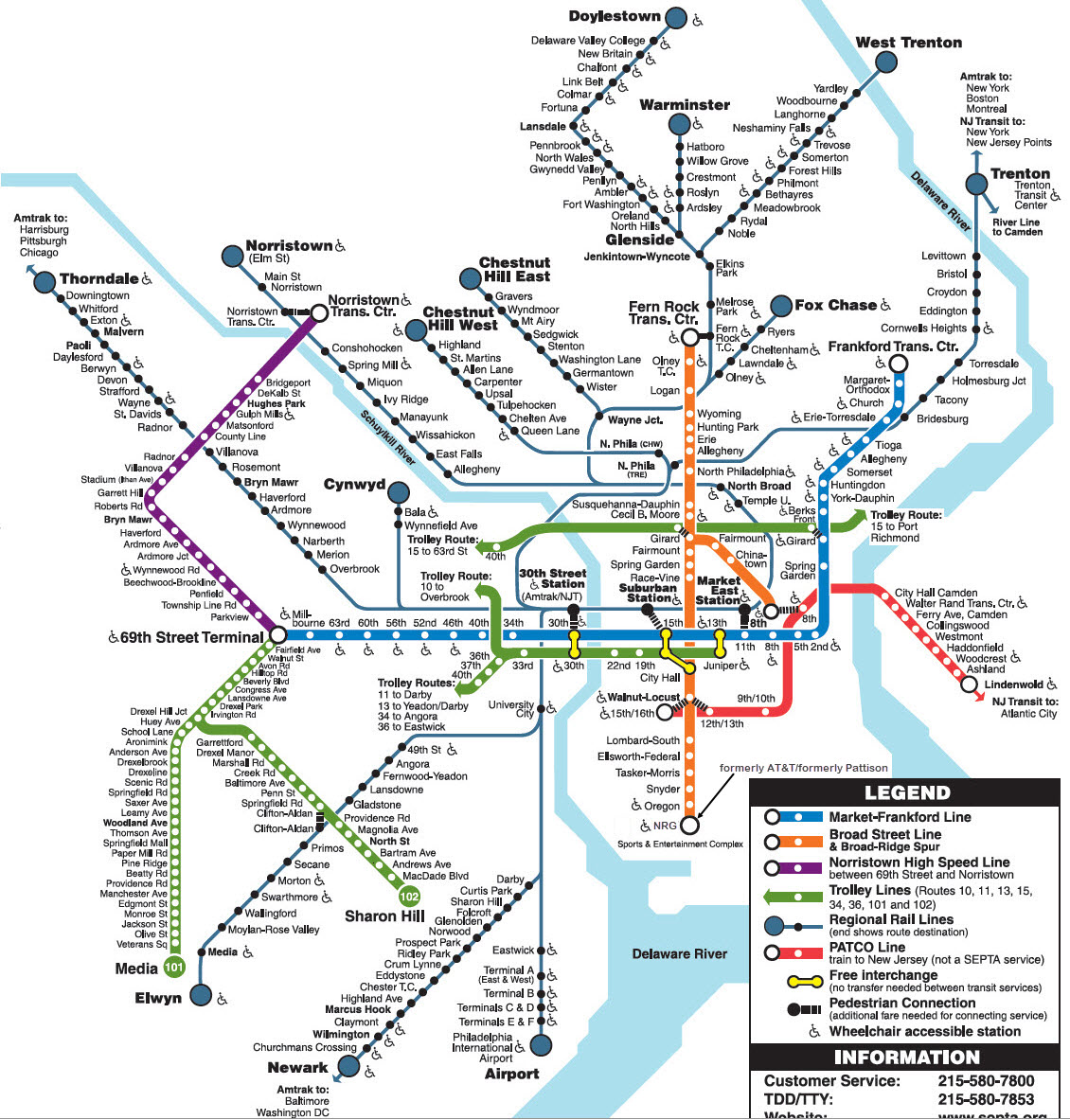
Map
Articles
Comments
RAILFAN GUIDES HOME
RAILROAD SIGNALS HOME
The Scoop:
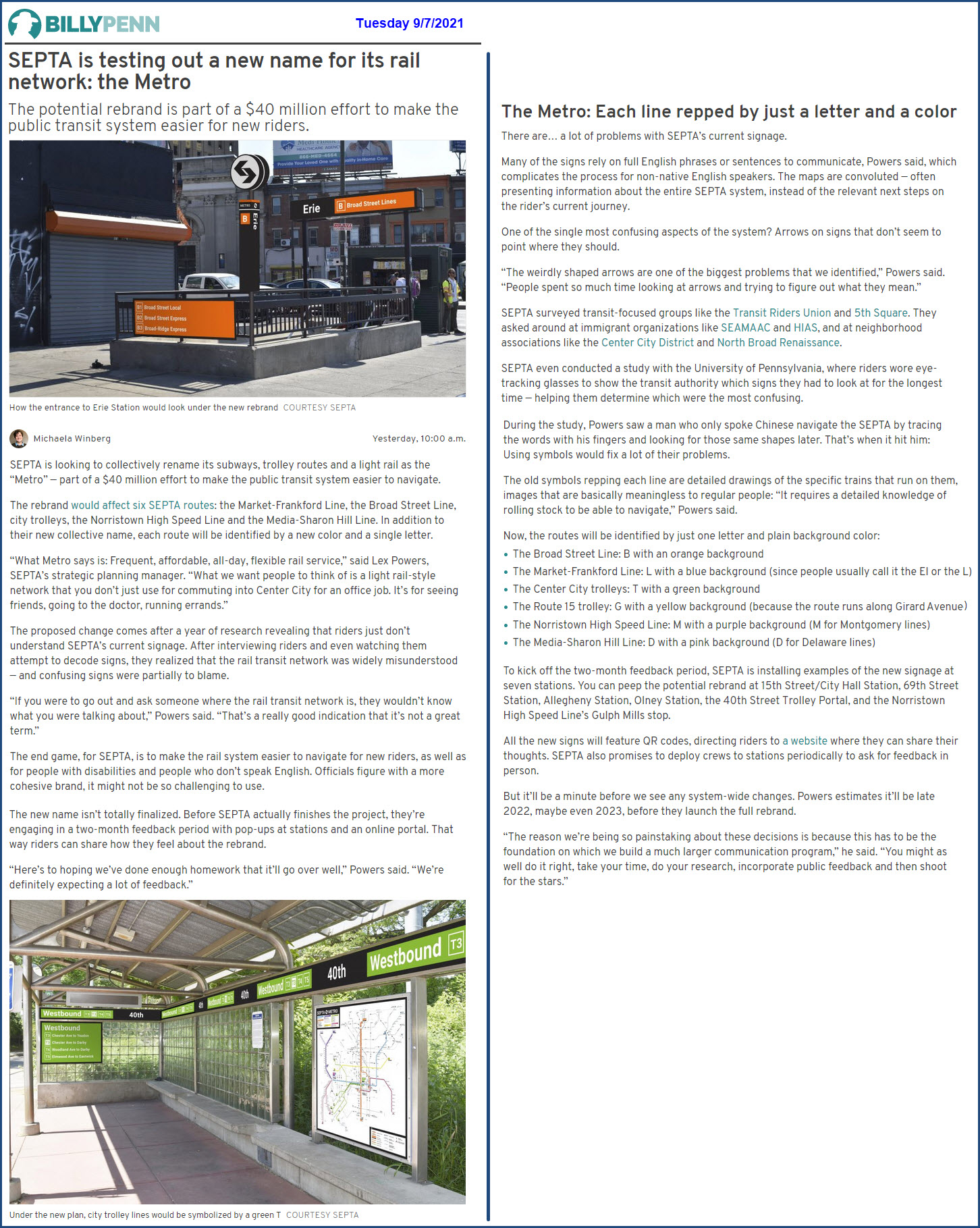
SEPTA recently announced that in an effort to make it easier to navigate the numerous rail lines and systems that make up SEPTA, they are in the process of "making things simpler".
My biggest question to them is: Are you REALLY going to make things easier, or is this just the upper management exercise in deciding on how to best waste 40 million dollars, without making it easier to navigate or by bringing in additional riders?
They have apparently had "studies" performed to show the inadequacy of the current naming and numbering system, citing too many names that are confusing to not only long time residents, but visitors as well. After visiting Philadelphia for well over 50 years, I have gotten to know the systems well enough to get around, but still not without a map - I don't think renaming or re-branding anything will really improve anything, because the system is so comprehensive and multi-modal, which, in and of itself, is more to blame than just the sheer size of the whole system.
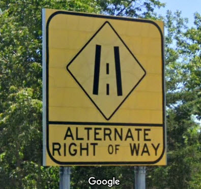
If they are truly trying to make things easier on visitors, naming everything (besides the commuter) lines to METRO is a big mistake, because almost every other country out there only uses the term METRO to describe a heavy rail / subway type system. If you want to confuse a foreigner, go ahead and use Metro on a tram line! For foreign visitors, this is the equivalent of using "alternate right of way" in place of "alternate merge" on a highway sign, as the Maryland DOT/SHA did when you come to the end of I-70 at the Baltimore Beltway. They will find MERGE in their translation booklets, but not likely to find right-of-way. Maybe the powers to be in SEPTA should consider naming the systems as they do internationally, then, foreign visitors would know what the hell they are referring to.
They also apparently want to "re-do" their rail map. WHY? It's great the way it is.....
In one of the comments below, a reader states that the Baltimore MTA system spent well over 100 million dollars to do the same thing, without any net increase in ridership... so how did the renaming of lines accomplish ANYTHING?
States and local municipalities that own and operate these systems are already financially strapped, so why would they want to take on additional debt that does not provide any extra income to help offset these re-branding costs? Yeah, I don't know either :-) You have often heard me say that if these companies had to make a profit, they sure would be run completely different!
As of September 2021, SEPTA is inviting comments, but most of us figure that it is a legal requirement, more than an honest "get the publics opinion opportunity". Having worked at the Baltimore Light Rail System for 4 years, and they did the same thing and even got the employees involved, they came up with every excuse in the book to NOT implement anything we suggested.... anything. It was all an exercise in futility. I suspect SEPTA will be no different, as they have probably already made up their minds.
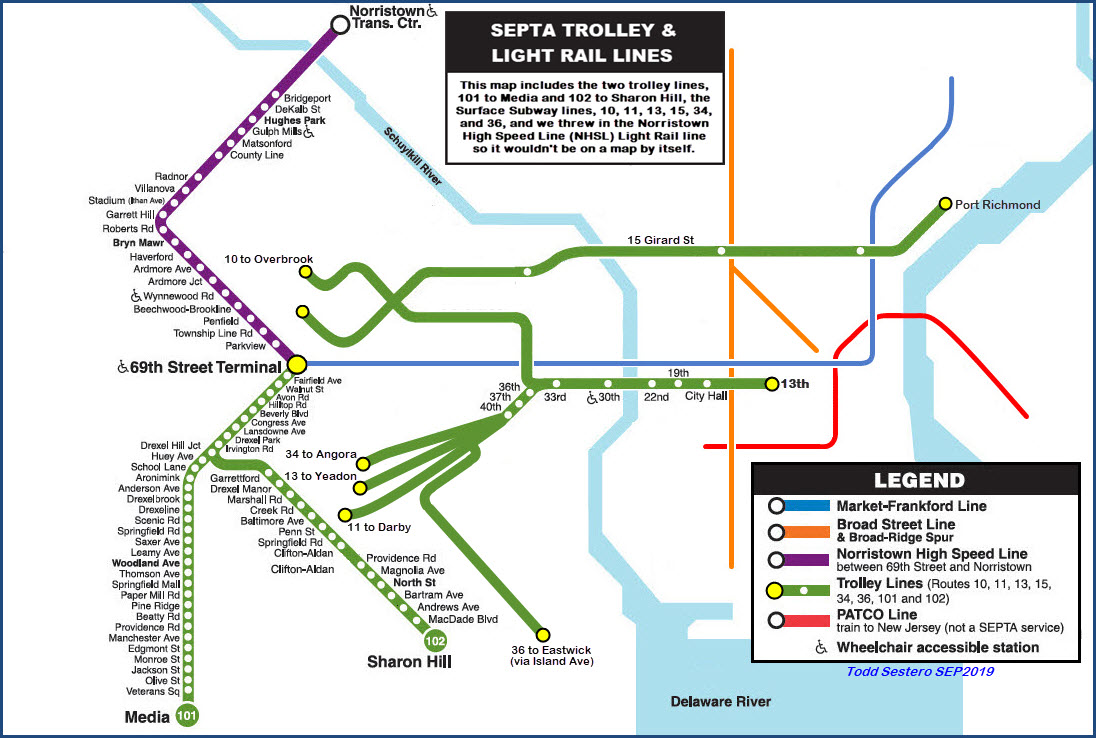
As most of us know, the SEPTA rail system includes:
• Regional commuter lines inherited from both the Reading RR and the Pennsylvania RR
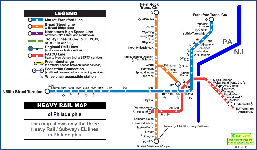
• Two subway / EL lines: the Broad Street line and the Market-Frankford line
• Numerous trolley lines referred to as the Subway Surface lines
• Another "subway surface" / trolley line, but usually denoted separately as the (#15) Girard Ave line
• Two "kind of" interurban trolley lines running on a lot of private right-of-ways going to Media and Sharon Hill
• A "high speed trolley line" going to Norristown using single car LRV's (light rail vehicles), but powered by a third rail
• AND, if you want to include it because it comes into Philadelphia, there is the PATCO heavy rail line going into New Jersey
• In addition to the rail lines, there is a plethora of standard bus lines, and there are several electric "trolley bus" or "trackless trolley" lines
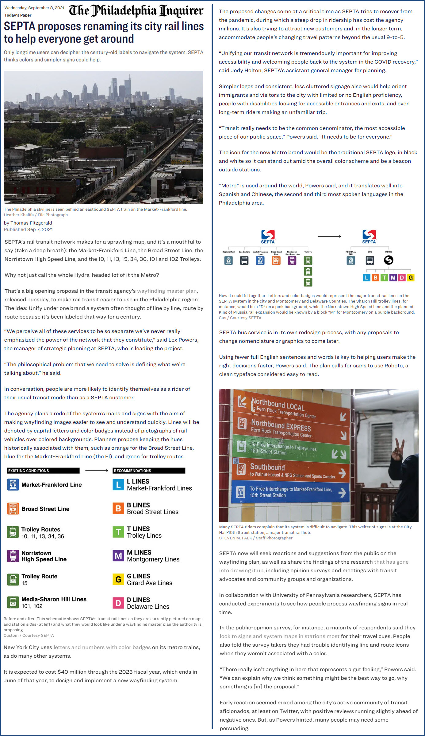
Here is the basic re-branding scheme in two parts, edited:
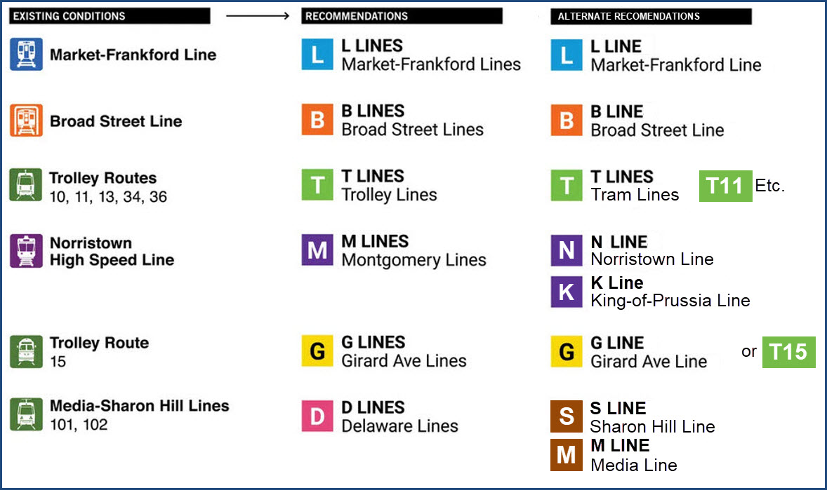
Here is my reasoning behind the alternate recommendations: I don't se any reason for using the plural for all lines (even though the Broad Street line has the Broad-Ridge spur). If they ever extend the Norristown line over to King-of-Prussia, keep the original line Norristown, and use "N", doing this frees-up the "M" for the Media line. If "we" ever get to King-of-Prussia, you can label it the "K" or "P" line. Instead of using Delaware lines, call them by their separate names, "S" and "M". NEITHER Montgomery or Delaware have any meaning to an out-of-towner, much less a foreigner - how many people know county names? So use their destinations to name the lines, besides, in New York City, you have multiple lines using the same tracks, and it works for them.... make it work here too instead of going from one confusing system to another!
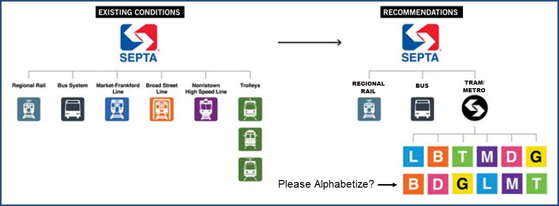
If you're going to have a list of the lines, please alphabetize them so we don't look like a bunch of two-year olds playing with blocks.
Acknowledgements:
SEPTA
Websites and other additional information sources of interest for the area:
https://planning.septa.org/projects/wayfinding-master-plan/
https://www.inquirer.com/transportation/septa-signs-directions-rail-transit-el-metro-20210907.html?utm_source=email&utm_campaign=edit_social_share_email_traffic&utm_medium=email&utm_content=&utm_term=&int_promo=
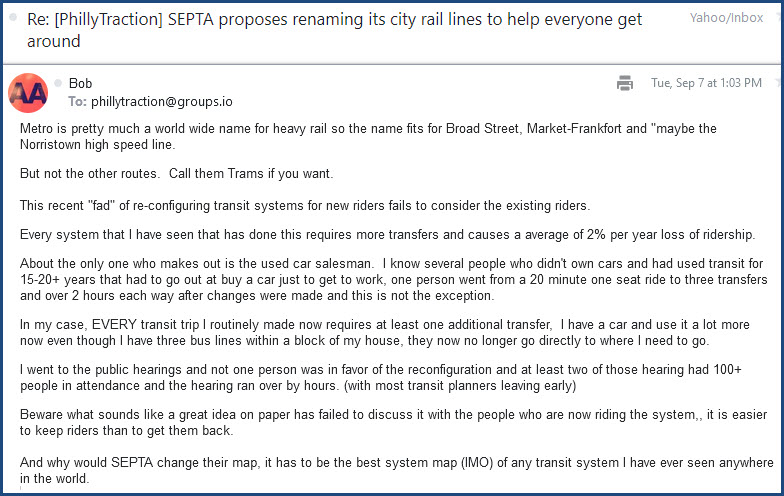
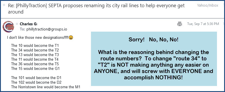
These are some of the comments floating around on one of the transportation groups on GROUPS.IO.
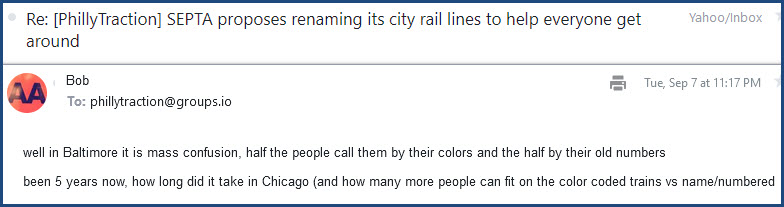

Bob makes a brilliant point about spending 135 million and not having any new riders for the effort!!! :-(
SEPTA is probably doomed to the same fate......
Disclaimers:
I love trains, and I love signals. I am not an expert. My webpages reflect what I find on the topic of the page. This is something I have fun with while trying to help others.
Please Note: Since the main focus of my two websites is railroad signals, the railfan guides are oriented towards the signal fan being able to locate them. For those of you into the modeling aspect of our hobby, my indexa page has a list of almost everything railroad oriented I can think of to provide you with at least a few pictures to help you detail your pike.
If this is a railfan page, every effort has been made to make sure that the information contained on this map and in this railfan guide is correct. Once in a while, an error may creep in :-)
My philosophy: Pictures and maps are worth a thousand words, especially for railfanning. Text descriptions only get you so far, especially if you get lost or disoriented. Take along good maps.... a GPS is OK to get somewhere, but maps are still better if you get lost! I belong to AAA, which allows you to get local maps for free when you visit the local branches. ADC puts out a nice series of county maps for the Washington DC area, but their state maps do not have the railroads on them. If you can find em, I like the National Geographic map book of the U.S..... good, clear, and concise graphics, and they do a really good job of showing you where tourist type attractions are, although they too lack the railroads. Other notes about specific areas will show up on that page if known.
Aerial shots were taken from either Google or Bing Maps as noted. Screen captures are made with Snagit, a Techsmith product... a great tool if you have never used it!
By the way, floobydust is a term I picked up 30-40 years ago from a National Semiconductor data book, and means miscellaneous and/or other stuff.
Pictures and additional information is always needed if anyone feels inclined to take 'em, send 'em, and share 'em, or if you have something to add or correct.... credit is always given! Please be NICE!!! Contact info is here
Beware: If used as a source, ANYTHING from Wikipedia must be treated as being possibly inaccurate, wrong, or not true.
SEPTA HOMEPAGE
RAILFAN GUIDES HOME
RAILROAD SIGNALS HOME
NEW 9/08/2021
Last Modified 08-Sep-2021