SEPTA HOMEPAGE
RAILFAN GUIDES HOME
RAILROAD SIGNALS HOME
As of 2019, the railroads running around in Philadelphia are Amtrak, Norfolk Southern, CSX, and Conrail (Shared Assets).
If we include commuter railroads we add SEPTA and New Jersey Transit to the mix.
And if we go one step further, and add transit, we add SEPTA and PATCO. However, by adding SEPTA, we broaden the variety to include one light rail line, two subway/EL lines, two trolley lines using pantographs on Kawasaki cars, four trolley lines using poles on Kawasaki cars, and one streetcar line using updated PCC cars.
Being both a railfan, and a transit fan, I find the variety of transit options more of a draw to come to Philadelphia than just trains, but that is just me. Philadelphia does offer some unique photo ops that do not exist elsewhere, like the high-line going thru downtown and the rare trolley/railroad grade crossing in Darby!
History
From 1924, Philadelphia had three major railroads: the B&O, the PRR, and the Reading. In 1924, the Reading was the successor to the Philadelphia and Reading Railway Company, which was founded in 1833. The B&O came into Philadelphia from the south, but did not have as much of a presence as either the Pennsy or the Reading, nor did it have any passenger service north of Baltimore past 1958 (north of Philadelphia, the B&O relied on trackage rights over the Central Railroad of New Jersey to get to Jersey City, where passengers then had to take a ferry to get to New York, while the Pennsy constructed the tunnel into New York and provided more direct service).
The next major change came in 1968 when the Penn Central was formed from the consolidation of the New York Central and Pennsylvania Railroads. So now we had the B&O, the Penn Central, and the Reading Railroads as Philadelphia's major freight railroads.
Amidst all of this, Amtrak was created in 1971, and with that, the Penn Central gave up it's inter-city passenger trains on the NEC and trains west to Chicago going thru Harrisburg and Altoona (and the Horseshoe Curve).
Then, on the B&O side, we had B&O colors until 1972, when it (officially) merged with the C&O and became the Chessie System.
The next major change occurred in 1976, with the big northeast consolidation that created Conrail. In Philadelphia, this changed the scenery by combining the Reading with the Penn Central. So now we are down to two major freight railroads, Conrail and the Chessie System.
In 1987, we saw CSX created with the merger of the Family Lines System and the Chessie System.
With the Conrail split in 1999, we saw the introduction of the Norfolk Southern into the region, taking over mostly lines going north and west, and CSX taking over one of the lines heading north into New Jersey and New York, a route that they did not previously have. Philadelphia is also one of only three areas to have part of the Conrail Shared Assets Operation around, (mostly) around the docks.
Additionally, we saw CP Rail and D&H trains come down to the docks via trackage rights in the 1980's and 1990's. Readers of Railpace Magazine will be familiar with coverage of these sightings.
Regional Commuter Service and Transit: Both the Pennsy and the Reading provided commuter service until 1968, then it was the Penn Central and the Reading until they became Conrail in 1976. Conrail continued commuter service until 1983, when SEPTA formally took control of commuter operations by forming their railroad division.
SEPTA acquired the Philadelphia Transportation Company (PTC) in 1968, and their operation included: trolley routes, trackless trolley routes, the Market–Frankford Line (subway/EL), the Broad Street Line (subway), and the Delaware River Bridge Line (subway-elevated rail to City Hall in Camden NJ).
In 1970, SEPTA acquired the Philadelphia Suburban Transportation Company, also known as the Red Arrow Lines, which included the Philadelphia and Western Railroad (P&W) route now called the Norristown High Speed Line, the Media and Sharon Hill Lines (Routes 101 and 102) and several suburban bus routes in Delaware County.
Additional Information:
https://en.wikipedia.org/wiki/SEPTA
https://en.wikipedia.org/wiki/Conrail_Shared_Assets_Operations
https://en.wikipedia.org/wiki/Reading_Company
https://en.wikipedia.org/wiki/Baltimore_and_Ohio_Railroad
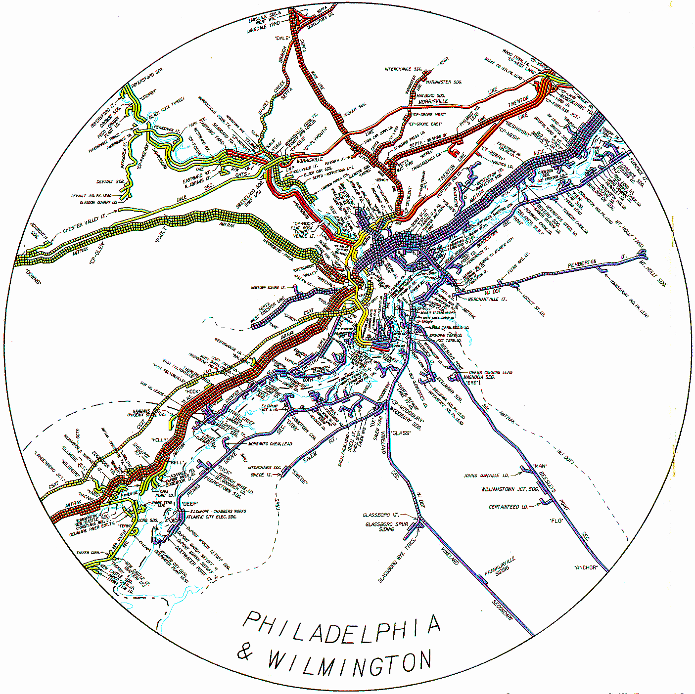
I know you have probably seen this map already on the Philly railfan guide homepage, but I present here again as a reminder of what went where during the Conrail days. We are also lucky that Conrail decided to include CSX on the map! The Bordentown Secondary in New Jersey is now NJT's River Light Rail line.
Disclaimers:
I love trains, and I love signals. I am not an expert. My webpages reflect what I find on the topic of the page. This is something I have fun with while trying to help others.
Please Note: Since the main focus of my two websites is railroad signals, the railfan guides are oriented towards the signal fan being able to locate them. For those of you into the modeling aspect of our hobby, my indexa page has a list of almost everything railroad oriented I can think of to provide you with at least a few pictures to help you detail your pike.
If this is a railfan page, every effort has been made to make sure that the information contained on this map and in this railfan guide is correct. Once in a while, an error may creep in :-)
My philosophy: Pictures and maps are worth a thousand words, especially for railfanning. Text descriptions only get you so far, especially if you get lost or disoriented. Take along good maps.... a GPS is OK to get somewhere, but maps are still better if you get lost! I belong to AAA, which allows you to get local maps for free when you visit the local branches. ADC puts out a nice series of county maps for the Washington DC area, but their state maps do not have the railroads on them. If you can find em, I like the National Geographic map book of the U.S..... good, clear, and concise graphics, and they do a really good job of showing you where tourist type attractions are, although they too lack the railroads. Other notes about specific areas will show up on that page if known.
Aerial shots were taken from either Google or Bing Maps as noted. Screen captures are made with Snagit, a Techsmith product... a great tool if you have never used it!
By the way, floobydust is a term I picked up 30-40 years ago from a National Semiconductor data book, and means miscellaneous and/or other stuff.
Pictures and additional information is always needed if anyone feels inclined to take 'em, send 'em, and share 'em, or if you have something to add or correct.... credit is always given! Please be NICE!!! Contact info is here
Beware: If used as a source, ANYTHING from Wikipedia must be treated as being possibly being inaccurate, wrong, or not true.
PHILADELPHIA GUIDE HOMEPAGE
SEPTA HOMEPAGE
RAILFAN GUIDES HOME
RAILROAD SIGNALS HOME
NEW OCT4/2019
Last Modified
05-Oct-2019