Access by train/transit:
Amtrak at Union Station
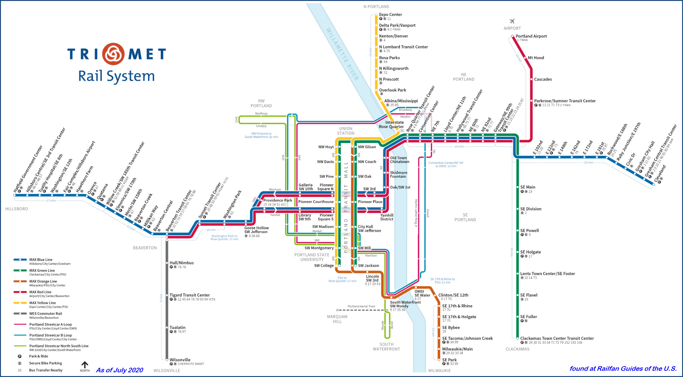
TriMet Light Rail
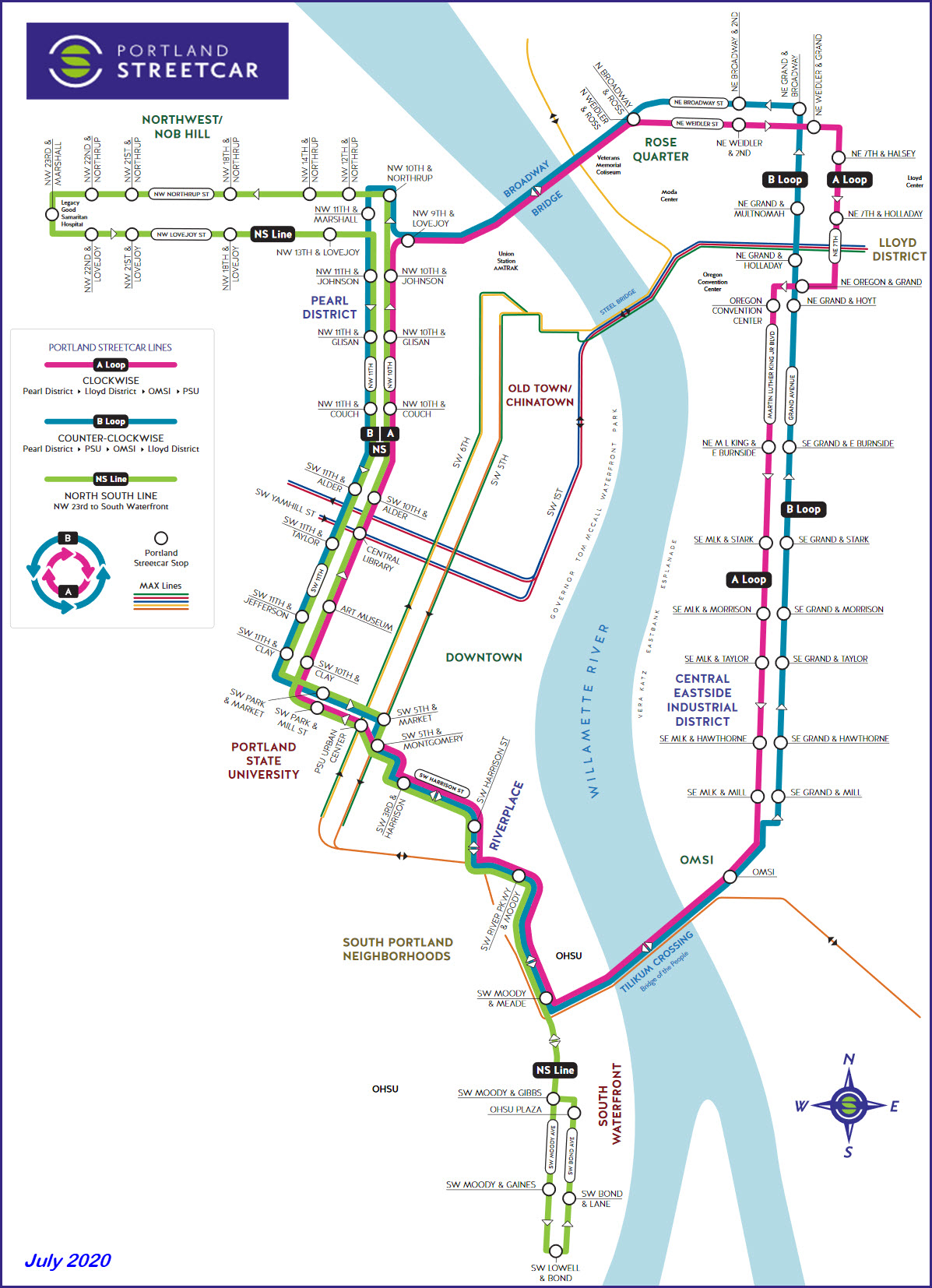
Portland Streetcar downtown
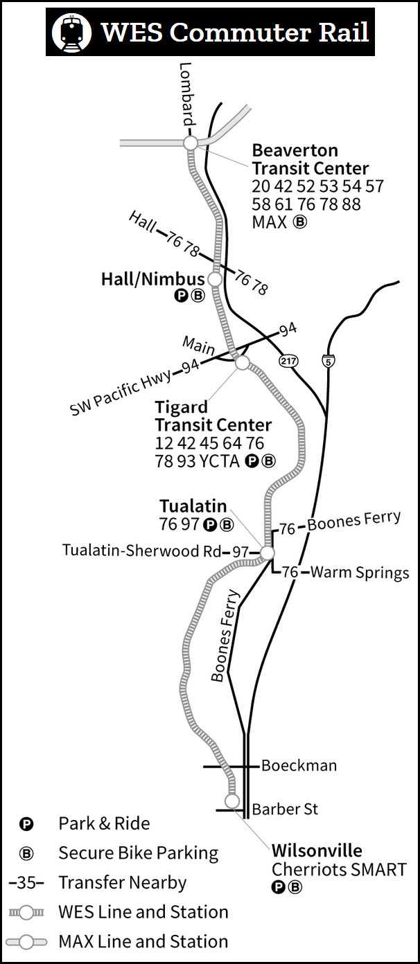
Commuter Rail in Beaverton
The Scoop:
Portland is Oregon's largest city, as such, it has a pretty well developed
rail transit system stretching as far as Wilsonville to the south of Beaverton.
The light rail system's Blue line, opened in several stages, started with a route on the east side
of town in Gresham heading into downtown. Then, after the massive tunnel project, it
headed west to Hillsboro. Because of the tunnel, TriMet has the deepest
light rail station (Washington Park) in the United States at 260 feet (79m). After
that, they opened the Red line to the airport, and the Yellow and Green lines.
The Green and Yellow lines service Union Station, and utilizes the famous
Steel Bridge, a multi-level vertical lift bridge with trains running on the
lower deck.
The Portland Streetcar opened in the downtown area in 2001. It is "kind of" a
separate operation from that of TriMet - it is owned by the city of
Portland, but operated and maintained by TriMet. When service was expanded
in 2012 to cross the Willamette River, it uses two additional bridges not used by TriMet's
Light Rail: the Broadway Bridge, and Tilikum Crossing. When the system
opened, it was the first new streetcar system in the United States to use modern
streetcars.
The Westside Express Service is a commuter rail operation that runs from
the light rail stop in Beaverton and runs down to Wilsonville. It opened in 2009, slightly ahead of schedule.
Trains run during the week, and service is a rush-hour operation only running
from approximately 5am to 9am, and then 3:30pm to 7pm, with 5 trains in each
direction during each period. They are scheduled to run every 30 minutes,
but during the Covid crisis, service has been reduced to every 45 minutes.
The Portland area has a lot
of interesting things for the rail and transit fan. Railroads servicing
Portland are the Union Pacific, BNSF, and the Willamette & Pacific. Both
the UP and BNSF have major yards around the downtown area.
Back during the years 1998-2002, I used
to get to Portland a couple of times a year on business. The company I use to work for
was headquartered in Beaverton (rip-IMS) :-(. I used to stay at the
Courtyard which backs up to the Willamette & Pacific, and I would ask for a room
in the back on the third floor... they always thought I was crazy, but it had a
great views of the freights coming by, especially at four in the morn.
If you are interested in learning more about the signals used on the MAX,
Michael H forwarded a link to a site
where signals and the light rail system are discussed in a blog format,
it is located here.
Acknowledgements:
Rick Holm
Greg Martin (rip)
Denver Todd
Individual transit maps for Portland are as follows:
HOME .... the Portland Transit Homepage Map 1 ..... Light Rail Overview/History/the LRV's Map 2 ..... the Portland Streetcar Map 3 ..... WES - the Westside Express Service Commuter Train Map 4 ..... the Downtown Area Map 5 ..... Light Rail West- Hillsboro to the tunnel Map 6 ..... Light Rail East - Rose Quarter to Gateway Map 7 ..... Light Rail - the Yellow Line - Rose Quarter to the Expo Center Map 8 ..... Light Rail - the Red Line - Gateway to the Airport Map 9 ..... Light Rail - the Blue Line - Gateway to Gresham Map 10 ... Light Rail - the Green Line - Gateway to Clackamas
Please note, some of the above transit pages are still maps only, not guides - as such, there are no pictures or information contained within.
I'm working on 'em, hang in there......
If you want to know where the railfan the trains of Portland, please check out the main Railfan Guides index page.
I would like to thank both Rick Holm of Vancouver WA, and
Greg Martin of Salem OR for taking the time to show me
around, taking me along to chase 4449, and helping me find things on my many trips to
Portland, Salem, and Eugene.
SYSTEM MAPS
Disclaimers:
I love trains, and I love signals. I am not an expert. My webpages reflect what I find on the topic of the page. This is something I have fun with while
trying to help others.
Please Note: Since the main focus of my two websites is railroad signals, the railfan guides are oriented towards the signal fan being able to locate them.
For those of you into the modeling aspect of our hobby, my
indexa page has a list of almost everything railroad oriented
I can think of to provide you with at least a few pictures to help you detail your pike.
If this is a railfan page, every effort has been made to make sure that the information contained on this map and in this railfan guide is correct. Once in a while,
an error may creep in :-)
My philosophy: Pictures and maps are worth a thousand words, especially for railfanning. Text descriptions only get you so far, especially if you get lost or
disoriented. Take along good maps.... a GPS is OK to get somewhere, but maps are still better if you get lost! I belong to AAA, which allows you to get
local maps for free when you visit the local branches. ADC puts out a nice series of county maps for the Washington DC area, but their state maps do not have the
railroads on them. If you can find em, I like the National Geographic map book of the U.S..... good, clear, and concise graphics, and they do a really good job
of showing you where tourist type attractions are, although they too lack the railroads. Other notes about specific areas will show up on that page if known.
Aerial shots were taken from either Google or Bing Maps as noted. Screen captures are made
with Snagit, a Techsmith product... a great tool if you have never used it!
By the way, floobydust is a term I picked up 30-40 years ago from a National Semiconductor data book, and means miscellaneous
and/or other stuff.
Pictures and additional information is always needed if anyone feels inclined to take 'em, send 'em, and share 'em, or if you have something to add or correct.... credit
is always given! Please be NICE!!! Contact info is here
Beware: If used as a source, ANYTHING from Wikipedia must be treated as being possibly being inaccurate, wrong, or not true.