
RAILFAN GUIDES of the U.S.
Todd's Railfan
Guide to
BINGHAMTON
NY
In General
Radios & Scanners
Non-railroad Information
Getting Here
Floobydust
RAILFAN GUIDES HOME
RAILROAD SIGNALS HOME
The Binghamton guide is divided as follows:
Overall Guide and General Information - this page
Map
1 - Binghamton Proper
Map 2 -
Southeast of Binghamton
Map 3 -
West of Binghamton
Map
4 -
North of Binghamton
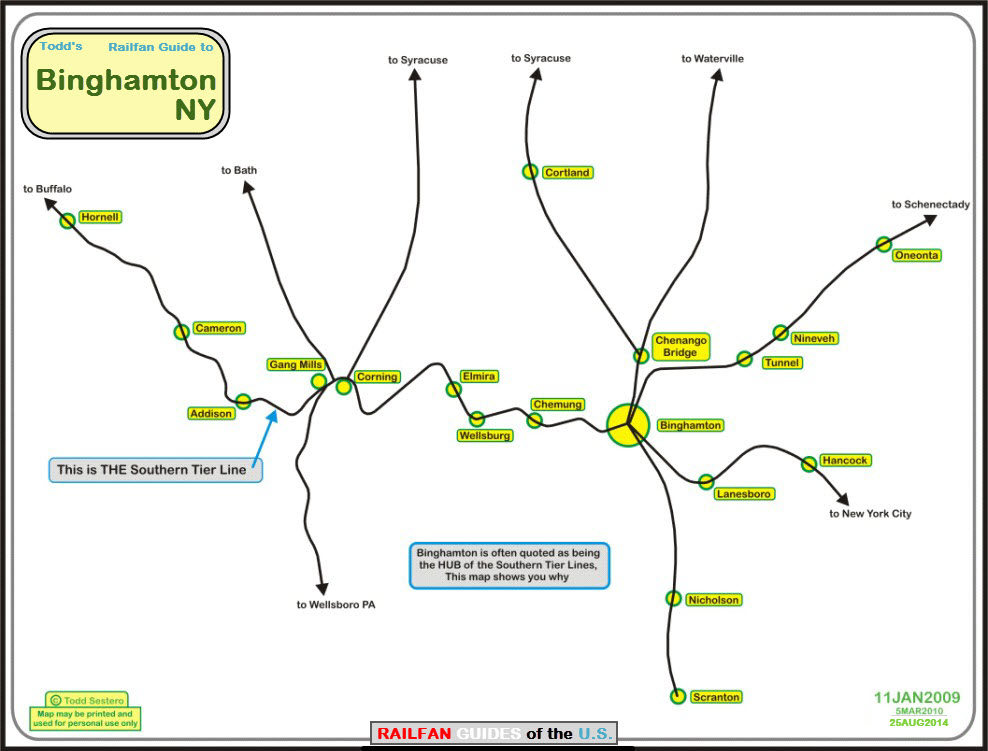
Of the four maps for the Binghamton area, Binghamton proper shows the downtown area of Binghamton along with the yards and the DL&W depot.
On this page is a map of the regions rail lines showing how Binghamton is the "hub" of railroading in southern New York state and the Southern Tier lines.
A map of the areas to the east and south of Binghamton includes Starrucca Viaduct, and Windsor.
I've also working on a map of the line heading north out of Binghamton, to Syracuse. The track does a pretty good job of following I-81 (or should I say the interstate does a pretty good job of following the railroad :-) to From Barker to Tully.
And then there is the map for the Southern Tier lines heading west out of Binghamton - we'll try to get all the way to Elmira if space permits on the map. The old signals have been falling recently and Niles has been out documenting their disappearance.
Binghamton is a relatively small town tucked away in the southern part of New York state, about 10 miles above the border with Pennsylvania, and about 50 miles north of Scranton PA, the home of Steamtown.
Binghamton is served by:
a) the Norfolk Southern via the Southern Tier route (ex Erie) from Buffalo
b) the Canadian Pacific, running on the old D&H line between Albany, Binghamton, and Scranton.
c) the Susquehanna, aka, the New York, Susquehanna and Western. Bingo serves as a "hub" between Utica, Syracuse, Port Jervis, and further onto Newark NJ. Susie-Q interchanges with the CP in Binghamton, the Norfolk Southern in Binghamton and Passaic NJ, and with the CSX in Syracuse, Utica, and Bergen NJ.
d) the Central New York RR between Binghamton and Port Jervis, 123 miles, over the old Erie route and the Starucca Viaduct - it started operation 31DEC2004, and leases the line from the NS. Both the CNYK and the Susie-Q are owned by the Otsego Corp. More info at www.cnyk.com
I've been to Binghamton on numerous occasions, but not early enough to have caught action in the pre-Penn Central days... darn... I imagine the railroad cops were probably a little nicer than the CP Rail guys are these days, they remind you of the KGB making the NS police seem like sand lot kids.... Back in 2002 when I was in town passing thru on business, I saw this one bull almost everywhere in town I went to see if I could find any action, and one time I stepped off the main road by about 10 feet to get a better shot - that old fart was right there to pull me over - good thing I wasn't in his "system", for he only wound up giving me a warning!
With that said, you can find Susquehanna, Norfolk Southern, and CP Rail running around. Now, I don't know all of the good spots, for I haven't had a tour by a local railfan. Outside of Binghamton, the tracks are pretty easy to chase and follow for the most part, especially the Susie-Q on the way to Port Jervis over the Starrucca Viaduct.
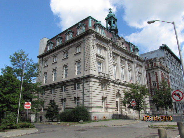
The biggest attraction downtown is the DL&W depot, nicely restored and has a couple of tenants. While you're there, check out the Marconi Tower at the far end of the depot, where he ran some early experiments in "radio".
Down on the south side of town on US11, is a spot where Susquehanna freights stop quite often before coming into town, near signal location 8 on the first map. Good place for pictures, and it's OK to park along 11.
On the north side at Bevier and Old State - altho at Old State one of the lines goes over you on an overpass, you have some nice grade crossings. I didn't get a chance to go any further out on the line in my latest visit at the beginning of '09, but in following the route on www.bing.com/maps, there are plenty more.
Good shots can be had at either end of the CP yard, but I wouldn't venture into it.... Too bad, for the birds eye view on maps.live.com shows engines from many roads....
The Susie-Q yard is easily accessed off of Brandywine, in between two overpasses. There is usually something around worthwhile to take pictures of. Sometimes they stage a bunch of engines deep in the yard, and unfortunately, there is no way in that I know of to get good pix off of Eldridge. Sometimes they spot a train coming from Port Jervis just south of location 8 on Court.
Also off Eldridge is a small Coach USA yard.
Just south of Bevier St is an old Erie signal location, with the signal hut, pole and signal heads still in place.
Onto the Southeast map. The most noteworthy feature of course is the Starrucca Viaduct. Very Cool! I believe the only thing using it any more are a couple of Susquehanna freights a day. There are a couple of other blog type places on the web where additional info can be found.
Underneath the viaduct, is where the D&H used to run. The R-O-W was torn up in the 80's, but a couple of bridges still remain. One of the pictures is a shot of one hanging in the hobby shop, no credit was given to the photographer.
South of the viaduct, in Susquehanna Depot is a really nicely restored Erie depot, now used as a restaurant. On display there is a semaphore among other things like some old rolling stock. There are some "tri-light" signals nearby.
West of Susquehanna Depot, on the other side of the river, is a passing siding with the still standing "SR" tower, and a set of "tri-light" signals.
Back up in Windsor is an old D&H freight shed, and the Village Train and Hobby Shop (jump to)..... if you're in the area, it's a must see... they specialize in Lionel stuff, have a lot of pictures in the "back" room, and have a display of really cool local stuff from the past.
AND, if you're travelling between Scranton and Binghamton, don't forget to stop by the Nicholson Viaduct!
Many thanks to Niles Chandler and Bob for information on railfanning Binghamton. I bumped into them downtown while taking pix of the NS freight in July of 2010.
Aerial shots were taken from either Google Maps or www.bing.com/maps as noted, once in a great while maybe MapQuest. The screen captures are made with Snagit, a Techsmith product... a great tool if you have never used it!Below are a couple of screenshots of info that came off of one blog about Bingo, and it re-enforces what I stated earlier about the CP cops, the corrections in the first snap-shot are in reference to Frog Rails listing for Binghamton:
Note: I believe scanners are illegal in the State of New York, and altho having a ham radio license may get you out of trouble in most instances, it's not guaranteed. As suggested below, if you are in the vicinity of a cop or railroad bull, I would turn the thing off.
In a little non railroad history,
Binghamton is the birthplace of:
IBM
Link Flight Simulators (now Rockwell
Collins)
and Dicks Sporting Goods - they started out as a fishing store on the East
Side.
The area boosts six carousels, and promotes itself as the carousel capitol of the world.
Rod Serling, host of the original Twilight Zone, was from Binghamton and he wrote it into several episodes. The episode "Walking Distance" is based on a carousel near his home. Cartoonist Johnny Hart is from Bingo, creator of "BC" and "The Wizard of Id".
The "X-Files" also had an episode where they chased a suspect through Binghamton, and in another episode, used the address "67 Bennett Ave", which was Serling's home address!
If you're old enough to remember Endicott-Johnson shoes, they also had their start in the area, with their namesake cites just to the west of Binghamton.
If you have any additional info you would like to share with the rest of us, it would be greatly appreciated.... please email me.
If you're coming up from the south on interstate 81, take exit 4 to get to the downtown area, or exit 2E if you want to start off with the south end of town and stop at the CP yard first.
If you're coming down from Syracuse on 81..... stay to the left as it hits 17/86, which will have you crossing the river, then take exit 4 or 2, depending on where you want to start.
From the Albany/Schenectady area, you would be coming in on interstate 88... take it till it runs into I81, and then take it south, following the instructions from Syracuse.
Coming in from the west you would be on US 17, or as they get along with the upgrades, interstate 86.
If you want to do downtown first, take exit 4 to head south on Brandywine, which is NY7 and 363. Stay to the right to stay on Brandywine instead of getting on N. Shore Dr, which goes over the railroads and most of the streets.
If you want to hit the NYS&W yard, now would be a good time, since the entrance if off Brandywine, in between overpasses for the tracks. So, far, I have never been bothered by anyone when going up for a quick check to see what's around, which usually is not a lot. Maybe you'll catch a few engines sitting by the office, maybe not. There is usually a few snowplows nearby.
If we start with the depot, we can get there in one of two ways, by taking a right on either Eldredge St (which is before the yards), or Henry St, which is after you go under the yards.
If you take Eldredge, you will skim along the north side of the yard, which doesn't offer much in the way of photo ops due to the business' along the road. When you hit Chenango, take a left, which will take you over the tracks, then hang a left on Lewis, where you will see the depot.
If you go down to Henry St, take a right onto Fayette St after you pass the stadium. Fayette forces you to take a left onto Lewis, where you will see the depot and the Marconi Tower.
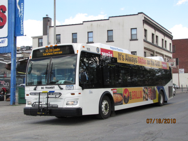
BC Transit #105 rolls past the Greyhound Bus Station on
Chenango.
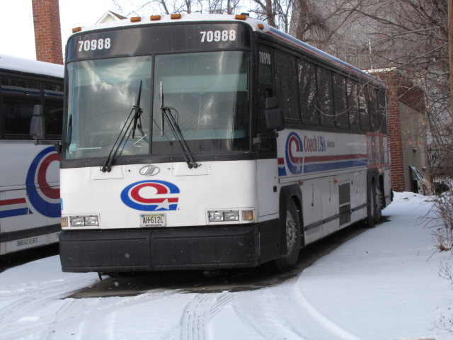

Coach USA / Shortline bus yard on
Eldridge, on the north side of the NS/NYS&W yard.
If you're looking for a place to stay, I recommend the
Clarion
on State St in downtown. They offer better deals than most of the
surrounding "suburban" hotels, altho the small parking lot fills up quickly, but
don't despair, there is a parking garage right next door, and it's free for
hotel guests. During the summer, on Friday evenings, they block off the
street for a block party, and one of the radio stations usually has a DJ to host
the event. Across from the hotel are quite a few bars and clubs to keep
you entertained when not railfanning.
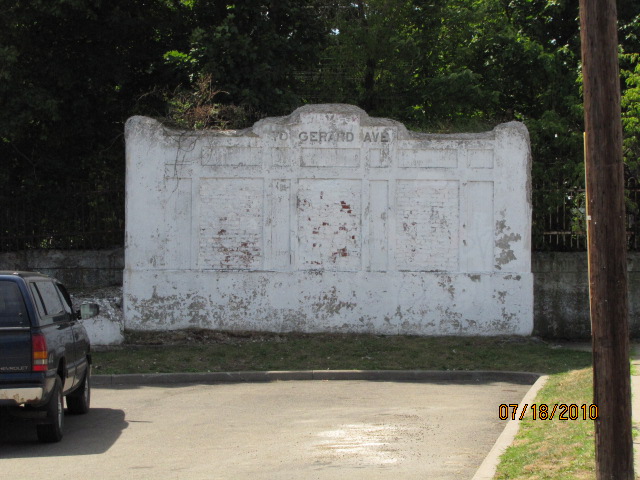
Along Clinton St, there are several of these underpass
entrances for walkways going under the railroad, this one is at Oak St.
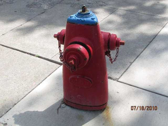
You can find these unique fire plugs about town if you look
hard enough.
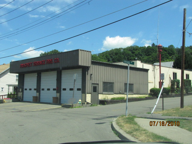
The Prospect Terrace Fire Station where Prospect St hits Downs
Ave by Hwy 17 exit 71.
Disclaimers:
I love trains, and I love signals. I am not an expert. My webpages reflect what I find on the topic of the page. This is something I have fun with while trying to help others. My webpages are an attempt at putting everything I can find of the subject in one convenient place. There are plenty of other good websites to help me in this effort, and they are listed in the links section on my indexa page, or as needed on individual pages. Please do not write to me about something that may be incorrect, and then hound the heck out of me if I do not respond to you in the manner you would like. I operate on the "Golden Rule Principle", and if you are not familiar with it, please acquaint yourself with how to treat people by reading Mathew 7:12 (among others, the principle exists in almost every religion). If you contact me (like some do, hi Paul) and try to make it a "non-fun" thing and start with the name calling, your name will go into my spambox list! :-)
Please Note: Since the main focus of my two websites is railroad signals, the railfan guides are oriented towards the signal fan being able to locate them. For those of you into the modeling aspect of our hobby, my indexa page has a list of almost everything railroad oriented I can think of to provide you with at least a few pictures to help you detail your pike.
If this is a railfan page, every effort has been made to make sure that the information contained on this map and in this railfan guide is correct. Once in a while, an error may creep in, especially if restaurants or gas stations open, close, or change names. Most of my maps are a result of personal observation after visiting these locations. I have always felt that a picture is worth a thousand words", and I feel annotated maps such as the ones I work up do the same justice for the railfan over a simple text description of the area. Since the main focus of my website is railroad signals, the railfan guides are oriented towards the signal fan being able to locate them. Since most of us railheads don't have just trains as a hobby, I have also tried to point out where other interesting sites of the area are.... things like fire stations, neat bridges, or other significant historical or geographical feature. While some may feel they shouldn't be included, these other things tend to make MY trips a lot more interesting.... stuff like where the C&O Canal has a bridge going over a river (the Monocacy Aqueduct) between Point of Rocks and Gaithersburg MD, it's way cool to realize this bridge to support a water "road" over a river was built in the 1830's!!!
My philosophy: Pictures and maps are worth a
thousand words, especially for railfanning. Text descriptions only
get you so far, especially if you get lost or disoriented. Take
along good maps.... a GPS is OK to get somewhere, but maps are still
better if you get lost! I belong to AAA, which allows you to get
local maps for free when you visit the local branches. ADC puts
out a nice series of county maps for the Washington DC area, but their
state maps do not have the railroads on them. If you can find em,
I like the National Geographic map book of the U.S..... good, clear, and
concise graphics, and they do a really good job of showing you where
tourist type attractions are, although they too lack the railroads.
Other notes about specific areas will show up on that page if known.
Pictures and additional information is always needed if anyone feels
inclined to take 'em, send 'em, and share 'em, or if you have
something to add or correct.... credit is always given! BE NICE!!! Contact info
is here
Beware: If used as a source, ANYTHING from Wikipedia must be treated as being possibly being inaccurate, wrong, or not true.
RAILFAN GUIDES HOME
RAILROAD SIGNALS HOME
NEW 1/282009
Last Modified 25-Aug-2014