![]()
In General
Getting Here
Map
Amtrak
Floobydust
USGS Maps
RAILROAD SIGNALS HOME
I don't usually have an introduction section in my railfan guides, because very few of them cover such a large area and huge number of railfan related "items".
When you discuss railfanning in the twin cities of Minneapolis and St Paul, it is hard to separate the two from each other because of their close proximity. Their downtown to downtown distance is less than 10 miles. Because of this, the homepage for both towns will look amazing similar, the only difference being on the St Paul homepage, the St Paul stuff will be at the top of the page, with Minneapolis stuff below. On the Minneapolis homepage, it will be just the opposite.
Other nearby towns and sights that will be included in the Minneapolis and St Paul guide:
The Wayzata 1906 Depot and Museum
Minnesota Commercial's New Brighton Yard
UP's Valley Park Yard - between Shakopee and Savage
New Brighton Junction
So let's get busy.....
Location / Name:
St Paul MN, Ramsey County
What's Here:
the Minnesota Transportation Museum
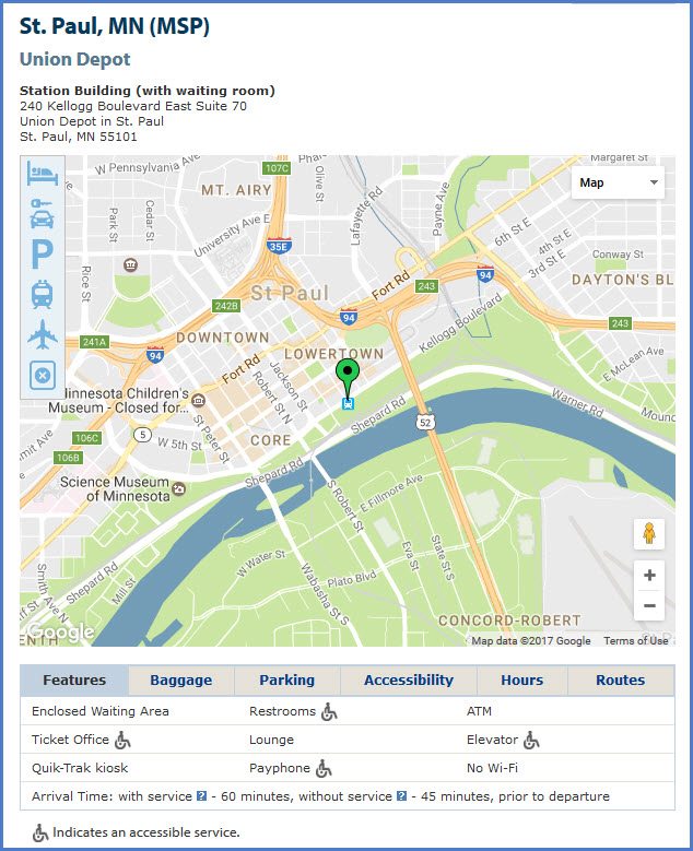
The Union Depot - downtown St Paul, former AND current Amtrak station
Midway Station - the former Amtrak station in St Paul
Yards:
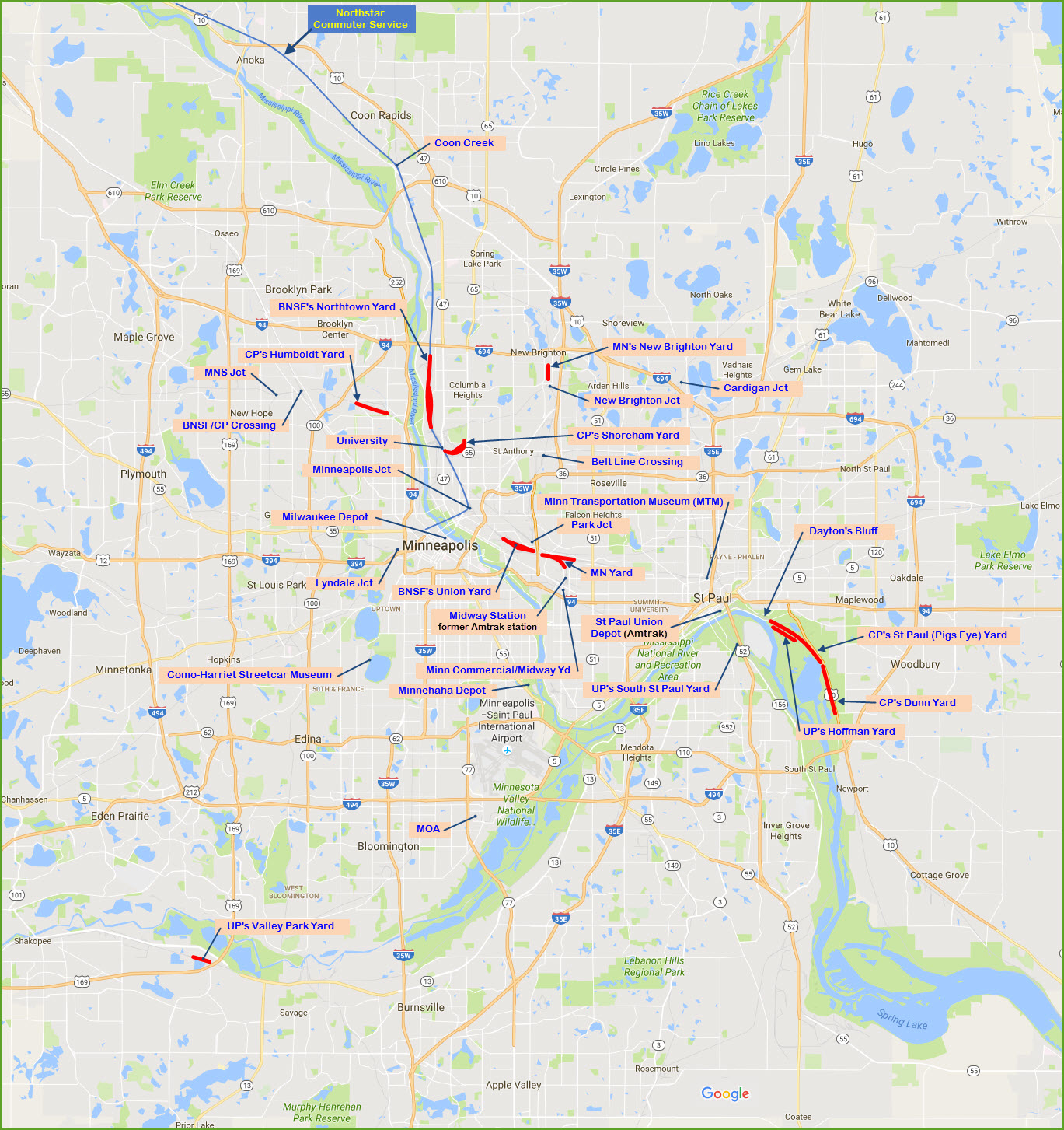
BNSF's Union Yard
UP's Hoffman Yard
UP's South St Paul Yard
CP's St Paul Yard, AKA, Pigs Eye Yard
CP's Dunn Yard - the lower half of Pigs Eye Yard
MC's Midland Yard - St Paul
Junctions:
Park Junction - very west side of St Paul
Belt Line Crossing - technically just north of the western side of St Paul
Data:
GPS Coordinates: as needed
ZIP: 55101 (downtown St Paul)
Area Code: 651
Access by train/transit:
The Green Line Light Rail services St Paul to Minneapolis
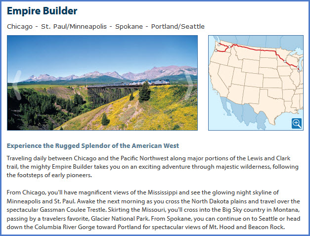
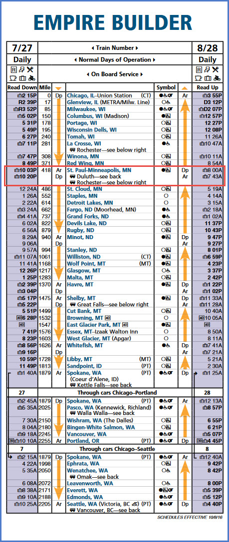
Amtrak Empire Builder stops in St Paul daily
The Scoop:
Minneapolis and St Paul is my favorite "city" to railfan, even above that of the likes of Chicago. I guess it may be the personal touch it received when I worked for IMS between 1998 and 2002 that got me here 4 or 5 times a year, from the most frigid of days, to the beautiful summer days. There is enough things to see that it easily would take you a week to see and explore everything, two weeks if you decide to venture farther out like Mason City IA, Duluth MN, Proctor MN, Albert Lea MN, St Cloud MN, Waseca MN, Owatonna MN, Hastings MN, Hinckley MN, and a host of others!
The incentive to start doing this guide was when I uncovered an old copy of Twin Rails by Prairie Works I got sometime around 2001/2002 from the fellow that published it. I went looking for information to see if things in the book were still there, and I basically found nothing on railfanning in the Twin-Cities area. There is a site by the model railroad club at the University of Minnesota which offers a fair starting place. So I thought I would add my own twist into the mix to help railfans. Anyone can help to make this guide by being a contributor, credit is always given and links provided if you have something "out there". My contact info is here
My favorite spots, which I almost always tried to hit even if I came in for a day or two are the north and south ends of Northtown Yard, and Dayton's Bluff, which I always stopped at before hitting the airport because of it's close proximately. My last trip to the area was in 2006, so I'm sure things have changed a little in those 11 years! So I will have to rely on the help of my friend Jim Mihalek to help me out. If you frequent my pages often, I'm sure you will recognize his name.
Railroads:
The Twin-Cities area is very fortunate to have a variety of railroads for your entertainment. UP, BNSF, and CP are the major players. Filling in the gaps are the Minnesota Commercial and the Twin Cities & Western. Back when I was coming here, you could also find the Wisconsin Central around New Brighton and Humboldt Yard/University. When I was coming here on a regular basis, you could still find an awful lot of SOO equipment running around - I'm guessing that is not so today.
Some of the railroads from days past are (some of the info came from 1894-99 era USGS maps):
the Chicago, Milwaukee, and St Paul RR
the Chicago, St Paul, Minneapolis & Omaha RR
the Chicago, Burlington & Northern RR
the St Paul & Duluth RR
the Elk River & St Cloud RR (GN)
the Duluth Short Line RR (NP)
the St Paul, Minneapolis & Pacific Coast RR (NP)
the Chicago Great Western RR
the Minneapolis, St Paul & Sault Ste Marie RR (SOO)
the Minnesota Belt Line RR
the Eastern RR of Minnesota (GN)
the Great Northern RR (BN)
the Northern Pacific RR (BN)
the Chicago, Burlington & Quincy RR (BN)
the Chicago North Western Rwy (UP)
the Burlington Northern RR (BNSF)
Yards: The Twin-City area has a bunch.....
The big one for BNSF is Northtown Yard, in northern Minneapolis/Fridley. A Home Depot at the north end of the yard, on the north side of I-694, provides a convenient place to train watch, it is adjacent to the Fridley Northstar station. 44th Ave provides a place for aerial shots as it passes over the middle of the yard. At the south end, "University" provides a good overall view of stuff in and out of Northtown, and stuff over at the Shoreham Yard.
For CP, their big one of the area is unquestionably the St Paul Yard, usually and incorrectly called Pigs Eye Yard. On the north side of Minneapolis, CP has the former Shoreham SOO yard, and west of that, Humboldt Yard.
Since the Union Pacific doesn't have that large a presence in the area, they have Hoffman Yard across from Pigs Eye, and on the south side of St Paul, they have the South St Paul Yard.
The Minnesota Commercial has a couple of yards, and has trackage rights almost everywhere. They have a yard where their office is located, they have Midway Yard, and they have the New Brighton Yard. I don't know if it still happens, but I caught a heavy UP freight with the then new SD-90's going up the MN's line into the New Brighton Yard (talked about on N0KFB's page). The MC is a very friendly place to visit, at least they used to be. You could sign a waiver in their office, and have free run of the yard as long as you didn't climb on anything. With all of the Alco's they used to own, it was a railfan's dream!
Stations/Depots:
St Paul has the area's only Amtrak station, and it has been moved back to Union Depot where it was originally. During the years I was coming to St Paul and Minneapolis for business, Amtrak had a single platform station located about halfway between the two cities, and was named the "Amtrak Midway Station". The Midway station was closed for passenger service on May 7, 2014, with passenger service being moved to the restored Saint Paul Union Depot. However, the station is still owned by Amtrak and continues to be used to service the Empire Builder.
For an area so rich with railroad history, there are surprisingly few remaining depots. The big one is the former Milwaukee Road depot in downtown Minneapolis, at the corner of 3rd Ave S, and S Washington Ave - a beautiful structure! Along Hiawatha Ave at 60th St is the Minnehaha Depot, carefully preserved in a park. Out west in Wayzata, is a depot and museum located along the BNSF.
Signals:
As far as signals go, the most unique thing the area has to offer are the Griswold Rotating Banner type grade crossing signals. Minneapolis was home to Griswold, so it is not surprising that they are all over the place - still (maybe not necessarily active, but.....) Otherwise, colorlight and "trilight" style colorlights rule the day........ oh, oh, oh, except for the south end of Pigs Eye yard, where Pennsy position type dwarf signals are used to tell the engineer when the rear end of his train is where it should be and he can stop.
Light Rail:
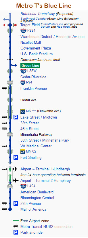
The twin-cities area currently (as of 2018) has two rail lines, the Blue and the Green. The Blue Line was the first line, opening up as the #55, Hiawatha Light Rail system on June 26, 2004. The line is 12mi/19.3km long. The T renamed the line on May 17, 2013 in an effort to standardize the naming of all their lines - both bus and light rail. The Blue Line goes from downtown Minneapolis to the Mall of America, where the station is under the mall in the parking area. The northern end of the line used to be at Nicollet Mall, but in 2009 work was started to extend the line north for the new baseball stadium, Target Field - the extension opened on November 14, 2009. The Target Field station is unique in terms of providing service, for below the station, on the BNSF tracks, is the southern most station for the Northstar Commuter line. The system runs about 22 hours a day, except for service between the two MSP Airport terminals, Lindbergh and Humphrey, where service is 24/7/365. On December 12, 2009, they opened a new station near the mall, the American Boulevard station.
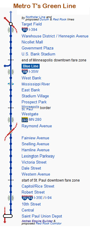
On June 14, 2014, they opened a second line going to St. Paul, the 11mi/18km long Green Line. This line was originally called the Central Corridor. The line runs from Target Field to Union Station in St Paul, and has 19 stations. The line is one of only six transit lines that runs 24hrs a day.
In 2009 and 2010, they lengthened the platforms to be able to accommodate three car trains. Previously, the stations could only handle a two car train.
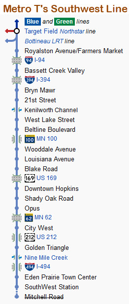
They are working on building a third line, the Southwest Line, going west to Eden Prairie. It is an extension of the Green Line, and is expected to add 15 stations over its 11.5mi/18.5km length. It is a line of great controversy with oodles of problems, with a lot of NIMBY's speaking up in protest to either slow down or halt construction, which in the end, will wind up costing everyone more money. If it gets completed without further delays, opened is expected in 2020.
 from Wikipedia
Other railroad items of interest:
In case you forgot, it was 20+ years ago that the BN and ATSF merged to form the BNSF, Dec 31st, 1996!
Other items of interest:
The Minnesota Renaissance Festival is 7mi south of Shakopee on Hwy 169. 2018 will be it's 47th year, and will be in it's current location through 2019, when they need to move to a new home. The faire is one of the largest in the country. It runs from the end of August thru October, but not into the Halloween weekend.
Bloomington, south of Minneapolis, is home to the largest mall of the United States - the Mall of America. It includes an amusement park in the middle of the mall, a huge Legoland with 10 foot tall dinosaurs, and an aquarium down below. It has four floors, and the food court is up on the 4th floor with an impressive view down. There is, or at least was, one national chain with a store on each of the four sides of the mall. The Blue Line light rail line ends it's service in the parking garage on the east side of the mall. People come from all over the world JUST to visit the MOA. By the way, the company who owns the MOA, also owns the largest mall in North America, somewhere up in Canada. And in the "for what it's worth department" - back around 1998 or so when I was also travelling to Albany, a mall in Schenectady was trying to obtain permission to build onto itself, and become the largest mall in America - the area people voted the plan down.
Last but not least, 3M used to have it's headquarters here; Medtronic, a leader in medical supplies and pacemakers, is headquartered in Fridley; and Target's HQ is in downtown Minneapolis. A few years back, one of the "guy" magazines, either Pop Mechanics or Popular Science, tagged Minneapolis as THE place to move to out of the entire U.S.A.
Acknowledgements:
Jim Mihalek: I met Jim on one of my trips to Daytons Bluff back in 1999 or so. Never so glad I met a railfan! He is very active, and goes out on signal trips to Ohio and other areas to document what's left.
Another fellow I met while on assignment to Medtronic's in Fridley, is Mike Miller. He gave me a bang-up tour of the T's L/R shops where he works in the signal department - pictures are on the Hiawatha line page. If you ever get to sit thru one of his ((OMG) slide presentations, they are the best - he has a great announcer voice! I owe both of these fellows a debt of gratitude!!!
Mitch Goldman
Websites and other additional information sources of interest for the area:
https://en.wikipedia.org/wiki/Midway_station_(Minnesota)
http://www.thedepotminneapolis.com/history.php
http://www.wayzata.org/Facilities/Facility/Details/Wayzata-Depot-and-Railroad-Museum-33
http://www.wayzatahistoricalsociety.org/visit/wayzata-depot-museum/
https://en.wikipedia.org/wiki/Wayzata_Subdivision
http://www.n0kfb.org/homepage/tc_rails/tc_rail1.htm railfan guide
https://www.facebook.com/pages/Wayzata-Train-Station/782597581763066
http://wayzatahistoricalsociety-org.depotmaps.com/Depot.htm
http://sites.mnhs.org/historic-sites/minnehaha-depot
http://www.thelinemedia.com/features/bluelinestops09222015.aspx stops not to miss on the Blue Line light rail
https://www.trainorders.com/discussion/read.php?1,4190948 info on Dayton's Bluff
http://www.northstar-nrhs.org/ the Northstar Railway Historical Society
http://www.comoshops.com/ a railfan oriented bookstore, located at Bandana Square
http://www.west2k.com/mnstations/hennepin.shtml railroad stations of Hennepin County
http://www.west2k.com/mnstations/anoka.shtml railroad stations of Anoka County
http://www.west2k.com/mnstations/mnstations.html Minnesota railroad station homepage
I-35 brings you up from the south, even if you are driving in from Dallas. I-35 goes on up into Duluth.
I-94 brings you in from Chicago and Milwaukee to the east, and Fargo ND and Seattle is you really want to drive that far.
MSP airport makes it convenient to getting here from almost anywhere, and MSP was the central hub for Northwest Airlines.
Amtrak has a daily train in each direction, the Chicago bound train is scheduled for around 8am, the WB train comes thru around 10pm. The station is in St Paul, and is the station used is the station used in the days of yore. It had been used as a post office. Service restarted here (I believe) in 2013.
I made the drive once from Baltimore in order to pick up a wig-wag signal I bought in western Wisconsin - it was a very long drive!!! A little over 1000 miles.
None so far....
Courtesy of the University of Texas Library, click here for their index page.
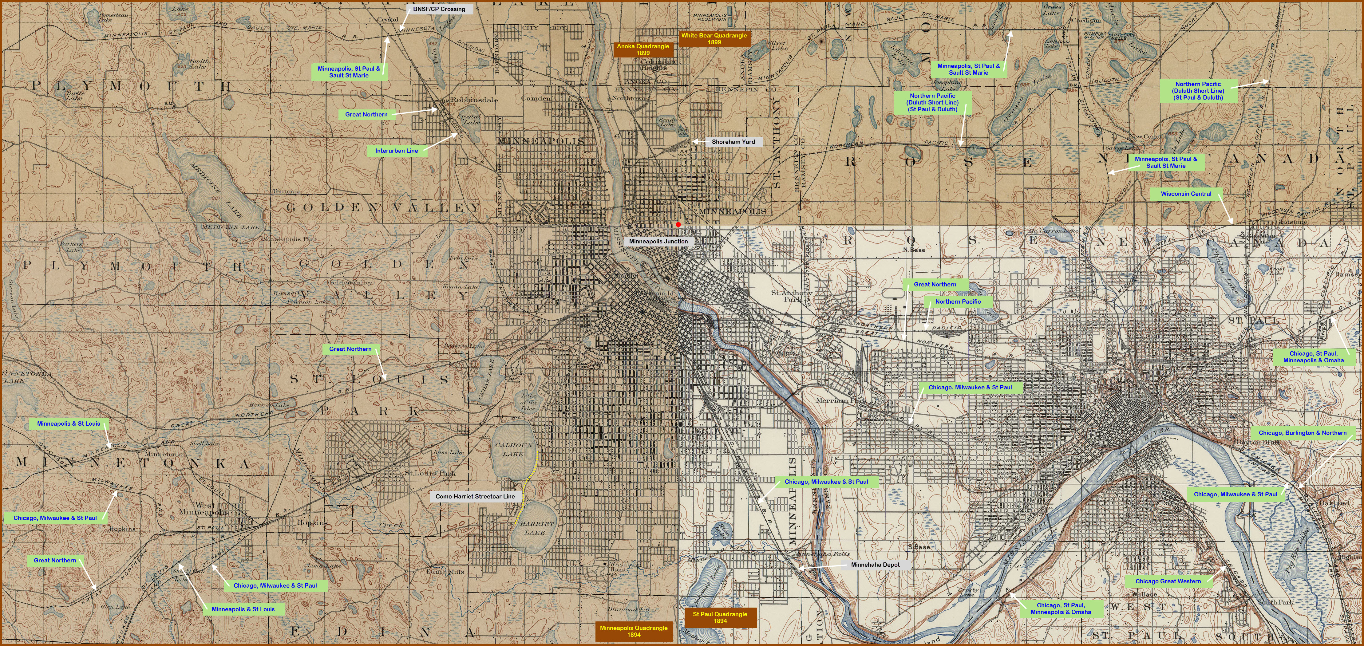
The map is a collage of four different quadrangle maps, as noted on the map.
Not all railroad names appear with their full name, so I took the liberty of noting them - they are the blue/green text boxes.
The black and grey text boxes denote stuff that is still around 120 years later.....
The red dot is the junction of the four maps, sorta like standing where NV, UT, CO, and AZ meet up! :-)
Hopkins is sort of like Suffolk VA, where the railroads heading to Norfolk converge going thru town on their way to Norfolk.
Disclaimers:
I love trains, and I love signals. I am not an expert. I do these pages because I love spending my time doing them - although I do a reasonable amount of research to make sure the information presented is accurate! :-) :-)
Please Note: Since the main focus of my two websites is railroad signals, the railfan guides are oriented towards the signal fan being able to locate them. For those of you into the modeling aspect of our hobby, my indexa page has a list of almost everything railroad oriented I can think of to provide you with at least a few pictures to help you detail your pike.
If this is a railfan page, every effort has been made to make sure that the information contained on this map and in this railfan guide is correct. Once in a while, an error may creep in, oooooooops, oh well! :-)
My philosophy: Pictures and maps are worth a thousand words, especially for railfanning. Text descriptions only get you so far, especially if you get lost or disoriented. Take along good maps.... a GPS is OK to get somewhere, but maps are still better if you get lost! I belong to AAA, which allows you to get local maps for free when you visit the local branches. ADC puts out a nice series of county maps for the Washington DC area, but their state maps do not have the railroads on them. If you can find em, I like the National Geographic map book of the U.S..... good, clear, and concise graphics, and they do a really good job of showing you where tourist type attractions are, although they too lack the railroads. Other notes about specific areas will show up on that page if known.
BTW, floobydust is a term I picked up 30-40 years ago from a National Semiconductor data book, and means miscellaneous and/or other stuff.
Pictures and additional information is always needed if anyone feels inclined to take 'em, send 'em, and share 'em, or if you have something to add or correct.... credit is always given! BE NICE!!! Contact info is here. Beware: If used as a source, ANYTHING from Wikipedia must be treated as being possibly being inaccurate, wrong, or not true.
RAILFAN GUIDES HOME
RAILROAD SIGNALS HOME
NEW
8/21/2018
Last Modified
22-Aug-2018