RAILFAN GUIDES of the U.S.
Todd's Railfan Guide to
INDIANAPOLIS IN
Homepage
In General
Getting Here
Map
Sights
Pictures
USGS Maps
RAILROAD SIGNALS HOME
Map 1 - West
Map 2 - Downtown
Map 3 - East
Location / Name:
Indianapolis IN
What's Here:
Amtrak Station (D)
Amtrak's Beech Grove Repair Facility (E)
Big Four / Avon Yard - CSX (W)
Hawthorne Yard (E)
the Indiana Railroad (D)
Indianapolis Motor Speedway (W)
(W) West, (D) Downtown, or (E) East
And What's Kinda Close:
the Linden Depot Museum, Linden IN (W)
the Indiana Transportation Museum, Noblesville IN
Dublin Fire EMS (E)
Data:
GPS Coordinates: 39.762468, -86.160006 (Center of the Amtrak Station downtown)
ZIP: 46204
County: Marion
Phone AC: 317/463
Access by train/transit:
Amtrak - downtown
The Scoop:
Indianapolis was, and still is, a great town to railfan in and around. There is plenty to do, and plenty to see as evidenced by the list above.
The largest and probably best known yard of the area is Avon Yard, AKA the Big-Four yard, west of town. Hawthorne Yard, on the east side, would be as large if it was still all there, but half of it is no gone. Amtrak has a station downtown. Railfans are lucky to have the Indiana Railroad in the downtown area - the railroad has become quite a major player in Indianapolis.
Railroads currently servicing Indianapolis:
CSX
Norfolk Southern
the Indiana RR
Railroads that used to serve Indianapolis in 1961:
the New York Central RR
the New York, Chicago & St Louis RR, aka, the NKP - Nickel Plate Road
the Baltimore & Ohio RR
the Pennsylvania RR
the Indianapolis Union RR
the Monon
Indianapolis Yards, Past & Present:
Hawthorne Yard (E)(PRR)
Brightwood Yard (NE)(Big Four - CCC&StL)(gone)
Avon Yard (W)(Big Four - CCC&StL)
Caven Yard (SW)(PRR)
West Yard (W)(Big Four - CCC&StL)(gone)
Moorefield Yard (NW)(Big Four - CCC&StL)(gone)
Moorefield Yard (NW)(B&O)(gone)
East Washington St Yard (SE)(PRR)
East Washington St Yard (SE)(B&O)
Hill Yard (SE)(CCC&StL)(gone)
North Yard (way NE)(NYC&StL-NKP)
4 Other Small Ones That Need Identifying..........
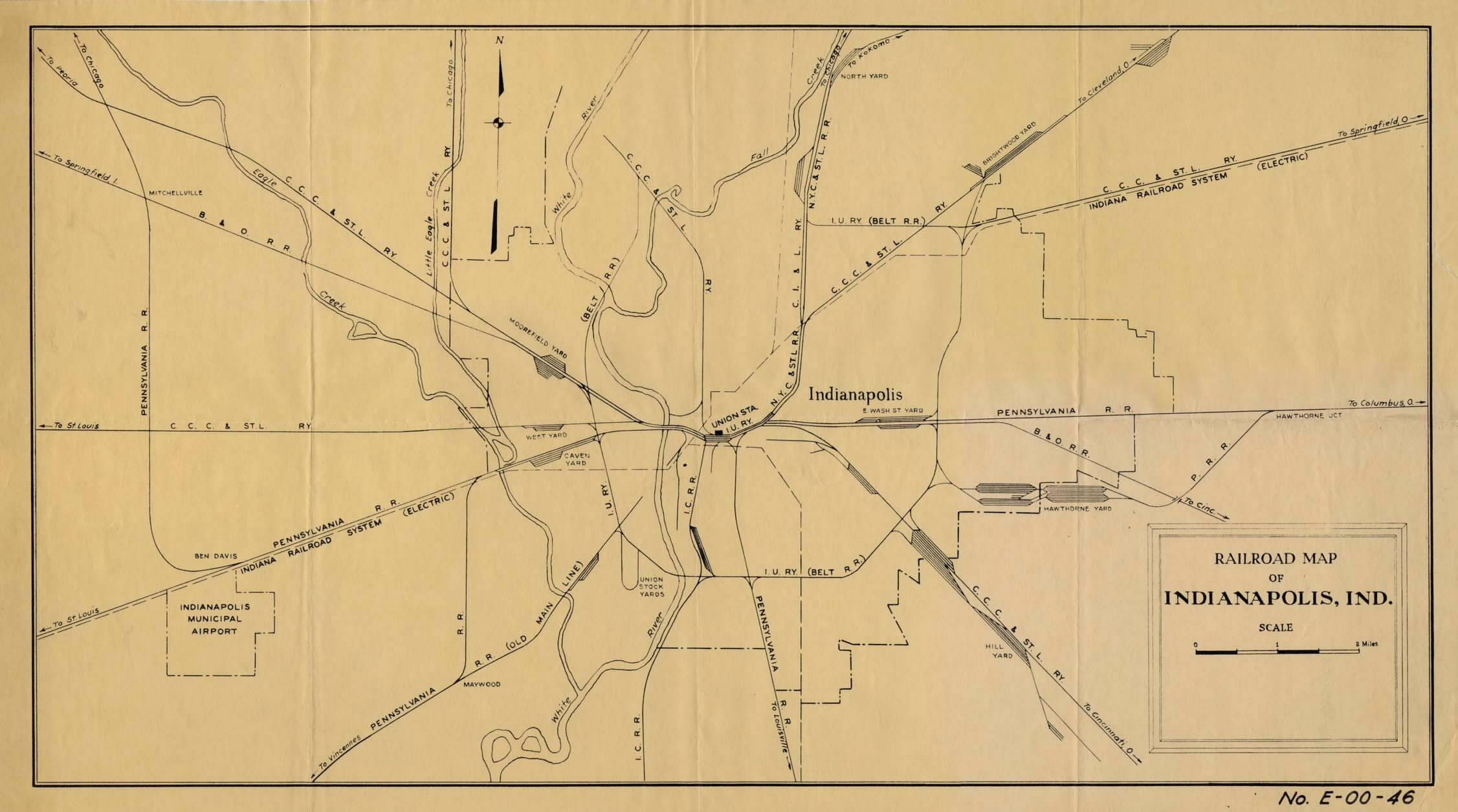
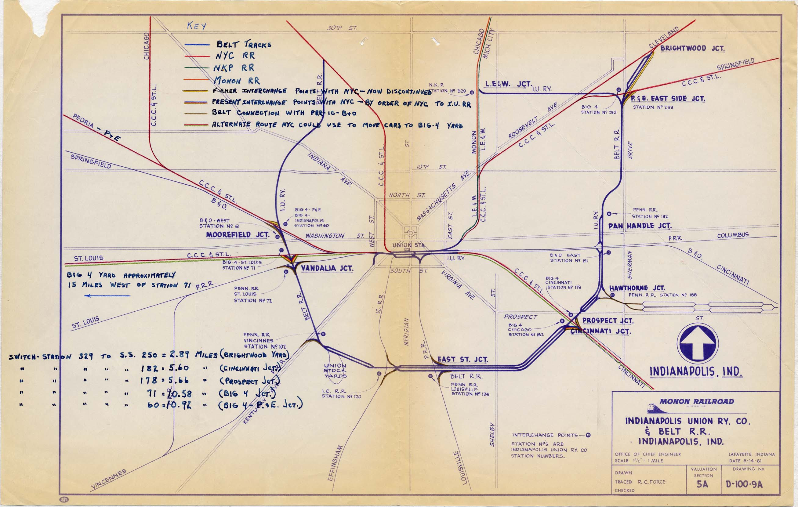
Stuff From the Old Maps Below That Is No Longer With Us:
Both Moorefield Yards
Brightwood Yard (no trace left)
The western part of Hawthorne yard where the roundhouse was is pretty much gone, altho the property is still there
Hill Yard
West Yard
The B&O and CCC&StL tracks heading out of town to the northwest
Moorefield Junction
The CCC&StL tracks heading north out of town - they stop just prior to I-465
All of the NKP and CI&L trackage heading north from the junction of I-65 and I-70 on the east side of town
The Belt RR tracks on the east side going east-west from LE&W Junction over to the P&E East Side Junction
The connecting track on the CCC&StL between the tracks running parallel to Massachusetts, and the CCC&StL tracks heading east to Springfield from P&E East Side Junction
Indianapolis is central to so many other great places to visit and/or railfan, it is hard to mention them all here:
Kokomo IN is about 50 miles due north on US31.
Ft Wayne IN is about 105 miles northeast via I-69.
Lafayette IN is about 60 miles northwest.
Champaign IL is about 115 miles west on I-74.
Terre Haute IN is about 70 miles southwest, and has a couple of towers on display that have been moved.
Cincinnati OH is 100 miles southeast via I-74.
Gary IN is about 165 miles up I-65 to the northish west.
The Linden Depot Museum about 53 miles away out I-74 west, then north on US231.
The Indiana Transportation Museum is in Noblesville IN, about 20mi NE.
Acknowledgements:
Tim Vermande, Gary Vierk, Google Maps, Bing Maps
Websites and other additional information sources of interest for the area:
https://www.facebook.com/groups/1730767260490888/ Indianapolis Head-Up Group
http://www.nuvo.net/GuestVoices/archives/2012/07/20/photos-of-indianapolis-public-transit-1890-1940
http://monon.org/4thMononScan.html
http://evansvillerail.blogspot.com/2011/09/another-day-another-company-chooses-us.html Not really pertinent to Indianapolis, but......
Aerial shots were taken from either Google Maps or www.bing.com/maps as noted. Screen captures are made with Snagit, a Techsmith product... a great tool if you have never used it!
This is a new page, and I am soliciting contributions to make it better. Please send contributions to me via my contact page (below).
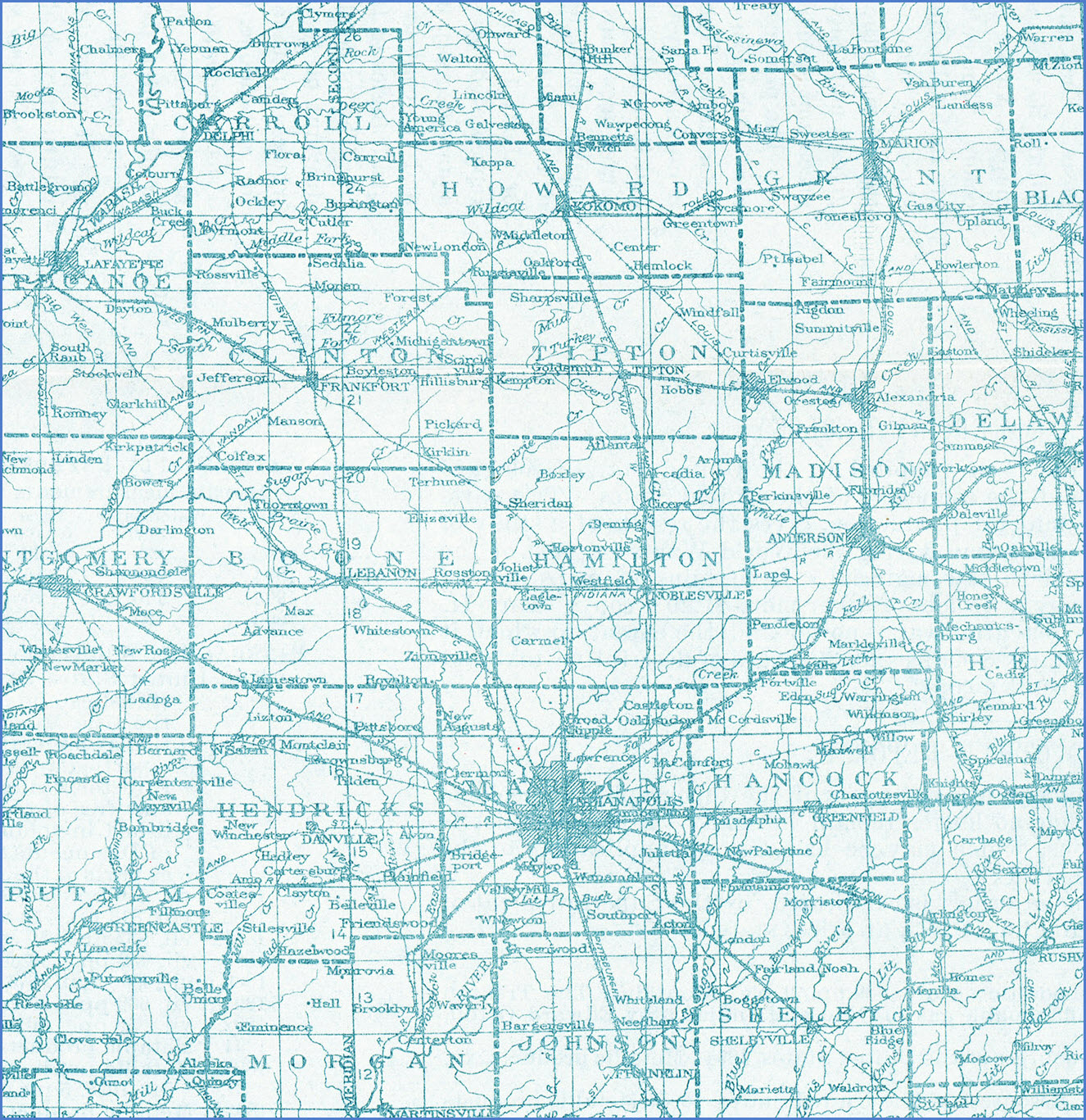
Here are a couple of maps to show you what has disappeared from Indianapolis over the past 50-60 years. Even when I was travelling to Indianapolis for business back in the 1998-2002 timeframe, you could still see old Pennsy and old B&O signals still standing, although not used (I saw ONE B&O CPL while driving on the highway one day, and could never figure out where it was when I went railfanning :-(. I'm sure they are long gone, as were most of the abandoned tracks portrayed in this section.
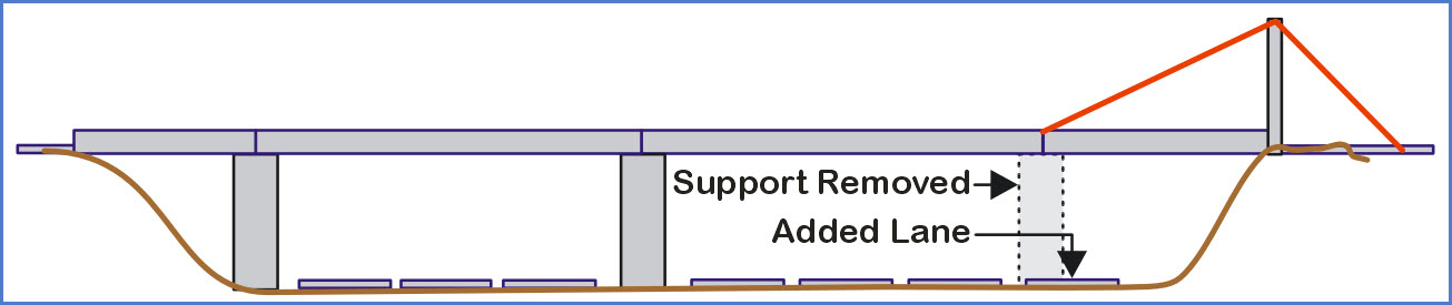
Besides train, electronics, and ham radio, I'm into bunches of other stuff. For instance, I'm always interested in what our highway designers keep doing, and the sometimes lame sheet they keep coming up with to make our lives "easier". If you are a regular reader, and have visited my DC pages, you will know that the I-95 HOV lanes on the south side of Washington DC has to be on the top of my list of "THINGS NOT TO DO". Why? They have wasted so much space, so much resources, and so much time and effort into building a reversible TWO LANE road, that can only be used by half of the highway at any one time, and sometimes, when it is completely closed, it provides NOTHING for the taxpayer... nothing! And if what they already built isn't enough, they are in the process of extending the insanity. They have already figured out how to capitalize on the HOV, and now charge to travel on it during peak hours, and non-HOV cars can now travel on the HOV lanes if you want to pay for the privilege. To me, it defeats the purpose. Baltimore lost it's distinction of having one of only two "twisted-knot" interchanges in the U.S. with the re-building of the I-695/I-95 interchange on the NE side of town. That project has been going on for 3 years, and is still not done, and they too, put in an HOV lane that non-HOV users can pay to use as an express lane (although ALL people using it have to pay!) Anyways, now that I have said my two cents for the morning, it appears that Indianapolis has done away with one of my favorite hiway "things" on I-465. Somewhere on the east side, they needed to make room for widening the highway, so they took out a support for an overpassing cross street, and cantilevered the supports. I have a picture/slide of it somewhere, I will have to see if I can dig it up.
In the meantime, it looks like Indiana has been very busy with highway projects around town, and here is some of the stuff I have seen while going around town on Google Maps.
The interchange between I-465 and I-65 on the southeast side of town is having a whole new ramp or two built, looks like it is a three-lane wide ramp (smart).
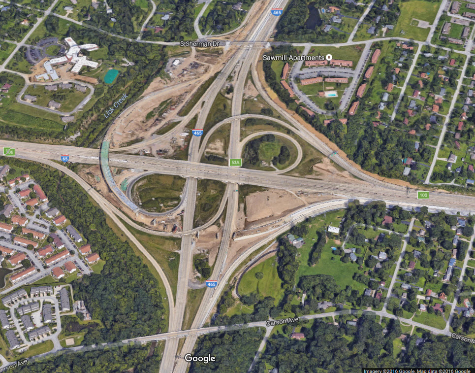
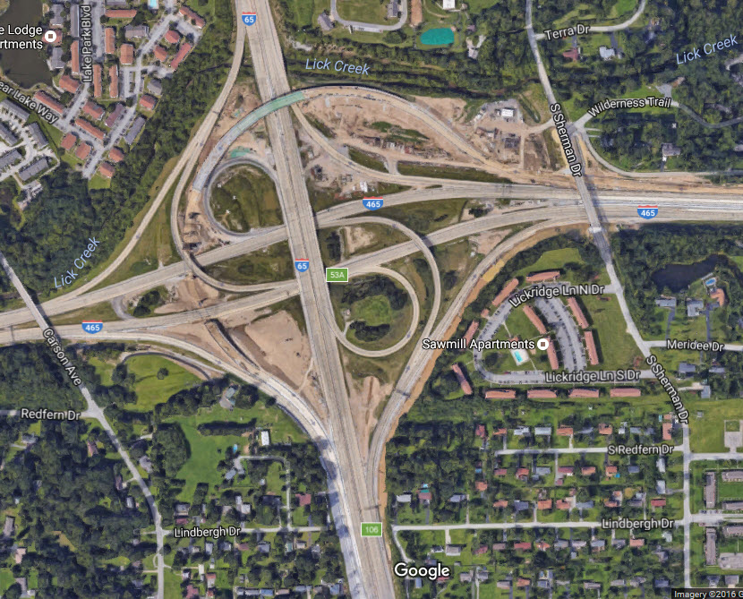
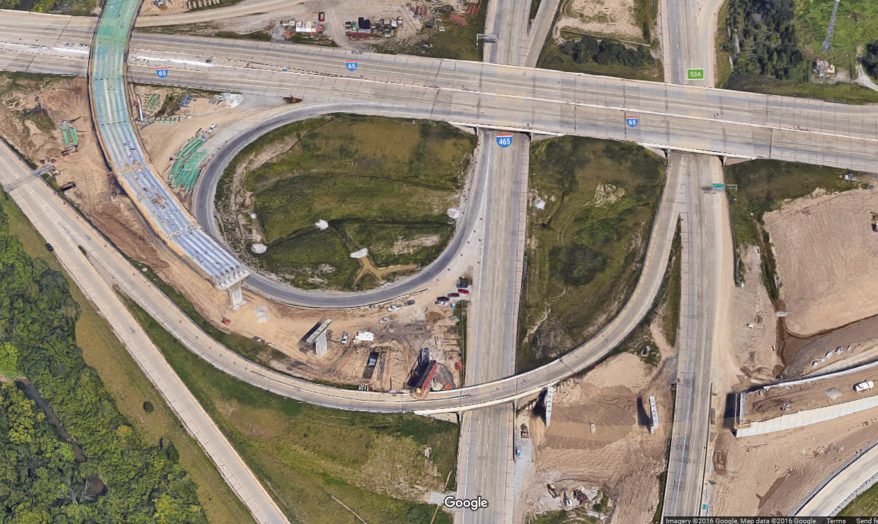
I wonder why the whole interchange was not done as a cloverleaf unless they were trying to separate exiting and entering traffic onto 465?......
Courtesy of the University of Texas Library, click here for their index page. There was nothing from the USGS for Indianapolis in the early years.....
Disclaimers:
I love trains, and I love signals. I am not an expert. I do these pages because I love spending my time doing them - although I do a reasonable amount of research to make sure the information presented is accurate! :-) :-)
Please Note: Since the main focus of my two websites is railroad signals, the railfan guides are oriented towards the signal fan being able to locate them. For those of you into the modeling aspect of our hobby, my indexa page has a list of almost everything railroad oriented I can think of to provide you with at least a few pictures to help you detail your pike.
If this is a railfan page, every effort has been made to make sure that the information contained on this map and in this railfan guide is correct. Once in a while, an error may creep in, oooooooops, oh well! :-)
My philosophy: Pictures and maps are worth a
thousand words, especially for railfanning. Text descriptions only
get you so far, especially if you get lost or disoriented. Take
along good maps.... a GPS is OK to get somewhere, but maps are still
better if you get lost! I belong to AAA, which allows you to get
local maps for free when you visit the local branches. ADC puts
out a nice series of county maps for the Washington DC area, but their
state maps do not have the railroads on them. If you can find em,
I like the National Geographic map book of the U.S..... good, clear, and
concise graphics, and they do a really good job of showing you where
tourist type attractions are, although they too lack the railroads.
Other notes about specific areas will show up on that page if known.
BTW, floobydust is
a term I picked up 30-40 years ago from a National Semiconductor data
book, and means miscellaneous and/or other stuff.
Pictures and additional information is always needed if anyone feels
inclined to take 'em, send 'em, and share 'em, or if you have
something to add or correct.... credit is always given! BE NICE!!! Contact info
is here
Beware: If used as a source, ANYTHING from Wikipedia must be treated as being possibly being inaccurate, wrong, or not true.
RAILFAN GUIDES HOME
RAILROAD SIGNALS HOME
NEW
10/26/2016
Last Modified
27-Oct-2016