RAILFAN GUIDES of the U.S.
Robert Mann's Railfan Guide to
JACKSONVILLE FL
the Southeast Side
the FLORIDA EAST COAST LINE SOUTH
In General
Getting Here
Details
Hotels
RAILROAD SIGNALS HOME
FEC RY / FLORIDA EAST COAST RAILWAY - "SOUTHSIDE"
This guide deals with the southeast side of Jacksonville and the Florida East Coast line heading "down" the coast.
These locations correspond with those on the map of the mostly white collar “Southside” of Jacksonville, the use of the term ‘EC' sets apart the areas of the city served by the FEC RY or East Coast. Note that except for two small pockets of urban decay, one which runs down US-1 from Atlantic southward to Bay Meadows Road on various sides of the railroad, and another in the much more northerly Arlington Area, the area known as “The Southside” is where the bulk of the old money in the city, if not the state originates. There are homes like the DuPont Family’s 'Epping Forest’ (now redeveloped into a community) to those along the Intercoastal Waterway in the area of The Mayo Clinic that would make much of the famed Palm Beach blush. Jacksonville financed modern Florida, it was an established city with a Union Station before Miami had three dozen settlers, and this large area is where about 1/3 of that money came from. While the other two money districts have faded considerably this region see’s nothing but explosive growth and new investment all the way to St. Augustine. As to the railroad, the Florida East Coast has transformed from the most aggressively anti-railfan to the most welcoming over the past 30 years, but please don’t abuse this and stay off the property, chances are you’ll get that friendly wave.
SAFETY
No place is perfectly safe, but my personal safety rating is based on 60+ years as a Jacksonville resident with extensive periods of time spent in such diverse places as Medellin, Colombia; Rio De Janeiro, Brazil; Oklahoma City, Oklahoma; Portland, Oregon or Los Angeles, California, and at least an equal amount of time as a railfan and Florida historian. While I'm certainly not claiming it's scientific or fool proof it should at the very least give you some idea of what to expect. I base it on the familiar scale of 0-10, with 0 being the worst and 10 being the safest possible situation. I make no guarantees or promises but trust it will aid you in some way.
Acknowledgement: I would like to thank Robert Mann for taking the time to write up this railfan guide for ya'll and sending it in to share with everyone. I hope you especially enjoy the extra tidbits he has thrown in so when you railfan the area, you can sound like you are from there! It's always nice to know a little more about the area you are in and some history about it. Especially welcome are his suggestions on where to eat and where to stay, for most maps (including my own) only tell you where they are, but never HOW they are!... Todd
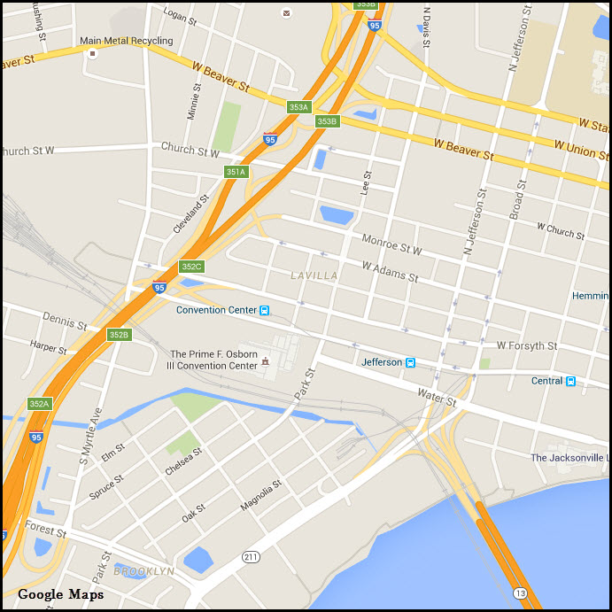
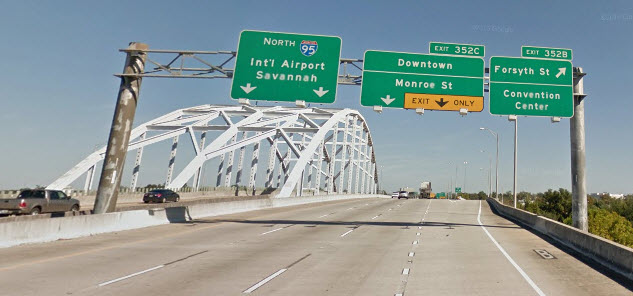
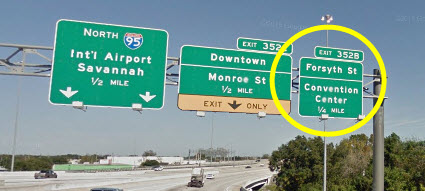
Exit 352B if you are northbound on I-95 after the junction with I-10. It is a messy and involved interchange, so you need to be paying attention if it is your first time through. Thius will dump you off on W. Forsyth St. You can take a right in 2 blocks on Park St to see what is happening at the crossing and the east end of the yard. or you can go another 3 blocks to Jefferson St, take a right, and it will put you on the bridge to take you across the St Johns River to start chasing with the guide.
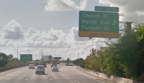
Exit 353A from SB I-95 will put you on Church St W. Take a left at the bottom of the ramp, go about 4 blocks and hang a right on Lee St, which turns into Park St.
From I-10, you can take the exit for Forsyth (and the Convention Center), which is exit 352B.
Details
FLORIDA EAST COAST LINE SOUTHEAST
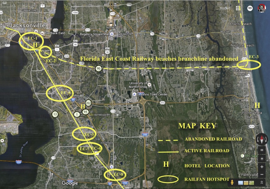
Take me to: EC-1 EC-2 EC-3 EC-4 EC-5 EC-6 EC-7 EC-8
Location EC-1
SOUTHBANK AREA OF THE URBAN CORE
Some excellent train watching can be had from the Riverwalk and Friendship Park. Paid parking is generally available next to the park at the restaurant or a block south in one of the garages. The Skyway monorail has three stations on the Southbank, it currently runs fare free on weekdays and special event days only. Depending on which parking facility or portion of the Riverwalk system one chooses, some pretty spectacular views of the rather famous double track Florida East Coast Railway bridge may be had. Transfer trains running between the Norfolk Southern and CSX interchange and yards and the FEC's Bowden Yard are moving all day and all night, you won't wait long anywhere here until something comes along. The downtown water taxi system is another way to grab some rarely seen views of the railroad bridge, don’t be afraid to ask the captain if he would mind swinging the boat around to give you that special angle, most of them will if they are not to hurried. Food and lodging are available nearby and a Skyway ride over the river to the Northbank urban core's Central Station and a short walk to the iconic Jacksonville Landing, affords excellent dockside dining with views of the railroad bridge. My personal safety rating for this area from the river front to as far south as the crossing of Atlantic Avenue in San Marco would be an easy 8-9.
Location EC-2
ST. NICHOLAS STATION
In the 2500 hundred block of Atlantic Avenue on the south side of the roadway, just west of the split with Beach Boulevard sits the tiny restored St. Nicholas Station and it's very own pocket park. This was typical of the wayside stations and is apparently the only surviving example of such a structure on the former Mayport Branchline of the Florida East Coast. A detailed stop at this little depot should consume no more then 30 minutes, accounting for measurements and photos. Public Parking is available just to the east in the shopping plaza's. The nearby Havana-Jax Restaurant is quite nice for an evening meal otherwise San Marco Square (which is more like a triangle) on Atlantic, two blocks west of Hendricks has some of the best foodie and shopping in the City. Married men will find their wives begging them to stay in San Marco (http://mysanmarco.com )! My personal safety rating for the St. Nicholas Station Park would be a solid 6-7 while your San Marco diversion would be a solid 9-10.
Location EC-3
JACKSONVILLE BEACHES HISTORICAL PARK, MAYPORT STATION, SECTION HOUSE, LOGGING LOCOMOTIVE
Just before Beach Boulevard meets the famous coastal highway A-1-A on the north side of the road sits a pretty amazing little cluster of historic buildings and of course the locomotive is just icing on the cake. If you are a railroader a detailed stop with measurements and photos could consume a couple of hours. If you are into some great history exhibits including photos, maps and graphics that explain both the freight and passenger reasons for the Mayport Branchline. You might be interested to know that Jacksonville Commissioner St. Elmo Acosta made multiple proposals to the City and County to purchase the branchline and convert it into a high speed interurban. His proposals were as up to date in the late 1920's through the mid 1930's as any modern day rapid transit system, even to the point of TOD (Transit Oriented Development). Unfortunately his idea's all fell on deaf ears and Jacksonville if not Florida's greatest opportunity to create a true Mid-West style interurban died. There is plenty of parking, on the diverging Pablo Avenue, needless to say that just blocks from the ocean food, lodging and myriad other attractions are close at hand. Safety in the Beaches Historical Park typically runs at 8-9.
Location EC-4
UNIVERSITY BOULEVARD OVERPASS
Just west of I-95 and US-1, University Boulevard passes over the northern throat of the Florida East Coast Railway's Bowden Yard. Transfer freights and containers from JAXPORT literally parade in from the north 24/7 and long freight drags featuring FEC's colorful array of road power come and go from the south end. Every imaginable fast food chain in the world is within a mile this way or that up and down University Boulevard and the nearby Publix supermarket (a few blocks west on University) makes some killer deli sandwiches. The biggest thing to consider here or anywhere else in Florida is just how important those photos are to you? In Florida a pedestrian is considered a fair target as Tampa, Orlando, Jacksonville and Miami lead the nation (currently in that order) in the number of needless fatal pedestrian/auto encounters. For this reason and the addition of a mix of industrial, lower income residential, transportation and clubs bring down the safety rating here to around a 4-5.
Location EC-5
BAYMEADOWS ROAD OVERPASS
Essentially this is the south end of Bowden Yard some amazing views of of the Florida East Coast's road freights can be taken from either side of this overpass whilst playing dodge-car with the heavy urban traffic. While there isn't as much to eat on this stretch of Bay Meadows Road, just to the east toward I-95 and a host of better family restaurants come into view. This end of the yard may appear a bit safer, but considering the surrounding neighborhoods and land uses and the fact that you're going to be standing alongside a road with pavement on one side and a sheer drop of 25 feet on the other, I'd give it nothing higher than a safety rating of 5.
Location EC-6
HISTORIC KINGS ROAD SOUTH
Originally built on orders from the King of England, this little road once connected the New Smyrna and St. Augustine colonies with those in rebellion somewhere to the north of the St. Mary's River. Today the road is diced and sliced but survives piecemeal in sections if not in whole in spirit. In this location it runs right alongside the Florida East Coast Mainline with a nice mowed/maintained median between the road and railroad. Be sure you observe the railroad's private right-of-way while your taking those photos. Tall pines to the east the median, roadway and small businesses and farms on the west, this is a killer spot for those late afternoon, sunset photos against a green backdrop. This site shares much of it's location and safety information with the following site at about 8-9
Location EC-7
SUNBEAM ROAD:
Railroad crossing and searchlight trackside signals, reduction from two to single track, just south of the entrance of the busy Bowden Yard this location is a favorite of local railfans. Trains are often held short of the signals to allow a northbound to clear before a southbound throttle's up for the trek to Miami. Northbound trains entering the yard from the south are usually a bit long to be handled whole forcing them to hold-out before they can enter the yard. Bear in mind that the stoplights in the turning lanes off of US-1 are tied to the signals on the railroad at Sunbeam Road, if you are too long at the Steak and Shake (excellent by the way) and racing for position as the train approaches from the south you might get cut off at the traffic light a full city block from the tracks! “What we have here is a failure to communicate…” if the name 'Sunbeam Road' seems vaguely familiar perhaps 'Sunbeam Road Prison #36' will jar the memory, 'Cool Hand Luke' the famous movie about the infamous road prison was based on a true story and this is where the horrible tale took place. Food is available near the railroad crossing, and family/fast food restaurants are scattered all along US-1 between Sunbeam Road and Mussells Acres Road. My safety rating for this neighborhood, is easily 8-9.
Location EC-8
MUSSELLS ACRES ROAD -or- AVENUE WALKS BOULEVARD
There is a large hidden shopping center, mixed use office and home tract being developed by Florida East Coast's sister company; Flagler Development. Someday this center will be a satellite city and as Jacksonville sprawls southward and the FEC RY expands passenger service north, this might be a marriage made in heaven. Access can be had either along the nearly hidden Musells Acres Road or by crossing over the soaring overpass at Avenues Walks Boulevard. The Florida East Coast Christmas Train uses this as their Jacksonville stop with it's large Wal-Mart plaza and parking lot handy to all elves. Trains can be captured here passing under the Avenues Walks Boulevard bridge, at the little two lane Mussells Acres Road crossing, dashing across recently cleared lots, or set deep in a pine woods, there are many options. Lot's of parking and food nearby at the Avenues Walks and along or across US-1 at the more upscale Avenues Mall. My safety rating for the Flagler tract is 9-10.
HOTELS AND LODGING
You have many choices where to stay, but For lodging in the EC or EAST COAST as in 'Florida East Coast' area of the city I personally recommend:
EC-1 & EC-2:
HILTON GARDEN AND HILTON HOMEWOOD SUITES - 1201 Kings Avenue, Jacksonville, FL 32207
Phone: 844-211-5706
EC-3:
PONTE VEDRA INN AND CLUB (Pricy but a touch of old Florida) - 200 Ponte Vedra Blvd., Ponte Vedra Beach, FL 32082
Phone: 904-395-5997
EC-4 -- EC-8:
BEST WESTERN - 4660 Salisbury Road, Jacksonville, FL 32256
Phone: 904-281-0900
Other Attractions in the 'EC' area:
Ft. Caroline National Monument
Ribault Column
Mayport ferry, fleet and seafood restaurants
Jacksonville, Neptune, Atlantic and Ponte Vedra Beaches
Jacksonville Museum of Science and History
Clarks Fish Camp (worlds largest collection of stuffed animals, you can eat with lions)
Jacksonville Skyway Monorail System
Historic Mandarin, Mandarin Museum and Historical Society
EC Area Shopping:
San Marco Square
Neptune and Atlantic Beach a shared historic Downtown
St. Johns Town Center (one of the largest shopping malls in Florida)
Avenue's Mall
Disclaimers:
I love trains, and I love signals. I am not an expert. My webpages reflect what I find on the topic of the page. This is something I have fun with while trying to help others. My webpages are an attempt at putting everything I can find of the subject in one convenient place. There are plenty of other good websites to help me in this effort, and they are listed in the links section on my indexa page, or as needed on individual pages. Please do not write to me about something that may be incorrect, and then hound the heck out of me if I do not respond to you in the manner you would like. I operate on the "Golden Rule Principle", and if you are not familiar with it, please acquaint yourself with how to treat people by reading Mathew 7:12 (among others, the principle exists in almost every religion). If you contact me (like some do, hi Paul) and try to make it a "non-fun" thing and start with the name calling, your name will go into my spambox list! :-)
Please Note: Since the main focus of my two websites is railroad signals, the railfan guides are oriented towards the signal fan being able to locate them. For those of you into the modeling aspect of our hobby, my indexa page has a list of almost everything railroad oriented I can think of to provide you with at least a few pictures to help you detail your pike.
If this is a railfan page, every effort has been made to make sure that the information contained on this map and in this railfan guide is correct. Once in a while, an error may creep in, especially if restaurants or gas stations open, close, or change names. Most of my maps are a result of personal observation after visiting these locations. I have always felt that a picture is worth a thousand words", and I feel annotated maps such as the ones I work up do the same justice for the railfan over a simple text description of the area. Since the main focus of my website is railroad signals, the railfan guides are oriented towards the signal fan being able to locate them. Since most of us railheads don't have just trains as a hobby, I have also tried to point out where other interesting sites of the area are.... things like fire stations, neat bridges, or other significant historical or geographical feature. While some may feel they shouldn't be included, these other things tend to make MY trips a lot more interesting.... stuff like where the C&O Canal has a bridge going over a river (the Monocacy Aqueduct) between Point of Rocks and Gaithersburg MD, it's way cool to realize this bridge to support a water "road" over a river was built in the 1830's!!!
My philosophy: Pictures and maps are worth a
thousand words, especially for railfanning. Text descriptions only
get you so far, especially if you get lost or disoriented. Take
along good maps.... a GPS is OK to get somewhere, but maps are still
better if you get lost! I belong to AAA, which allows you to get
local maps for free when you visit the local branches. ADC puts
out a nice series of county maps for the Washington DC area, but their
state maps do not have the railroads on them. If you can find em,
I like the National Geographic map book of the U.S..... good, clear, and
concise graphics, and they do a really good job of showing you where
tourist type attractions are, although they too lack the railroads.
Other notes about specific areas will show up on that page if known.
Aerial shots were taken from
www.bing.com/maps. The screen
captures
from Bing are made with Snagit, a
Techsmith product... a great
tool if you have never used it!
Beware: If used as a source, ANYTHING from Wikipedia must be treated as being possibly being inaccurate, wrong, or not true.
RAILFAN GUIDES HOME
RAILROAD SIGNALS HOME
NEW
3FEB2016
Last Modified
04-Feb-2016