In General
Getting Here
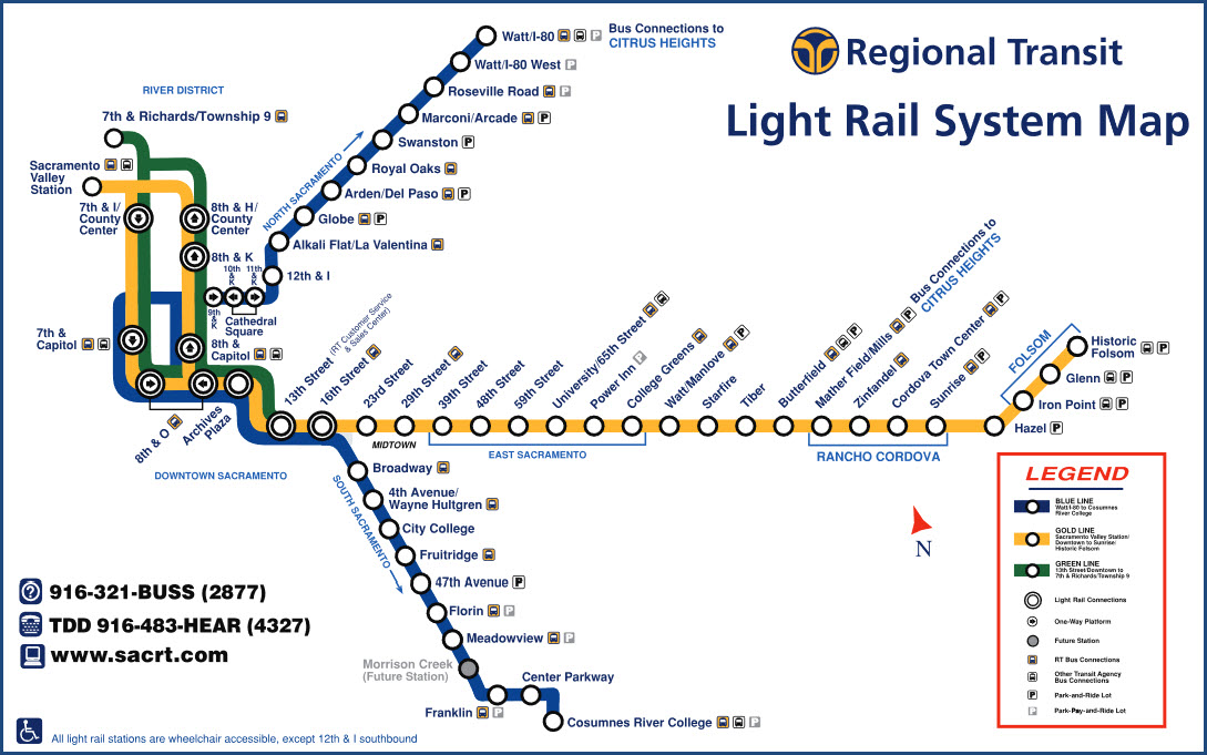
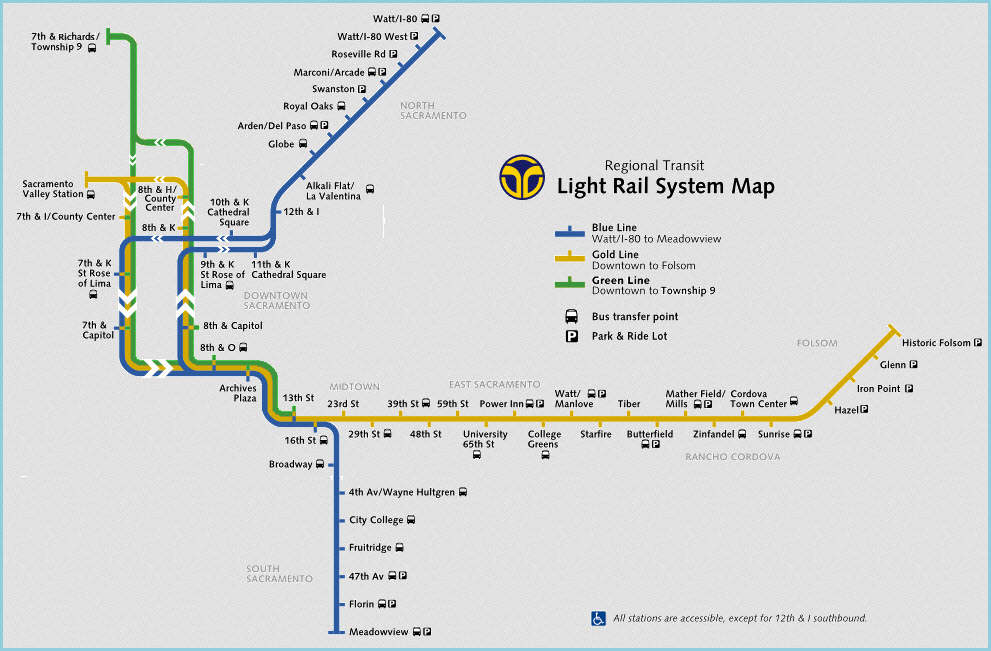
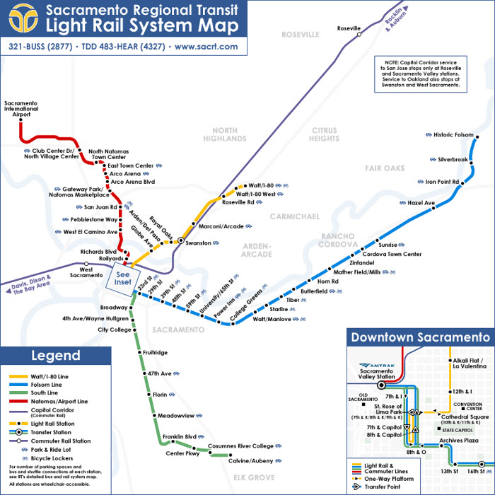
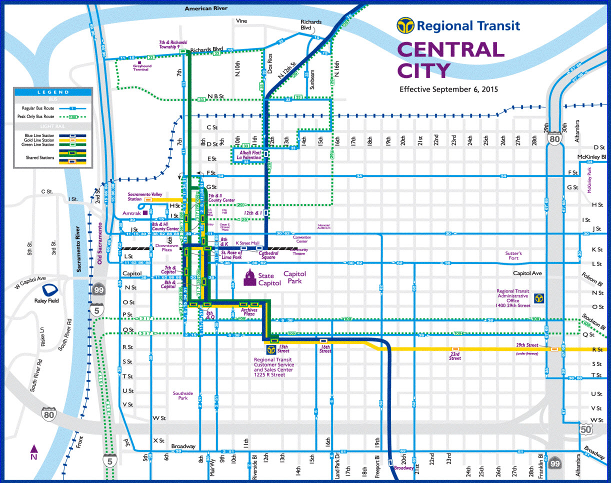
Map
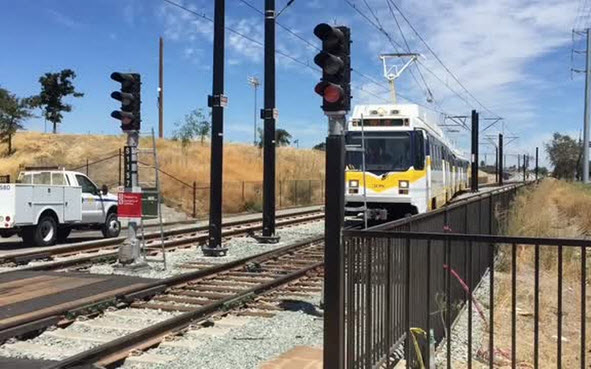
Pictures
Signals
Floobydust
RAILROAD SIGNALS HOME
Location / Name:
Sacramento CA, Sacramento County
What's Here:
This page is for the Sacramento Light Rail System
CA State RR Museum (a short walk from the Sacramento Valley Station)
There is plenty more to railfan in town....
Data:
GPS Coordinates: 38.576533, -121.493277 (Capitol Building)
Phone A/C: 916
ZIP: 95814 (dntn)
Access by train/transit:
Amtrak - Sacramento Valley Station
The Scoop:
From Wikipedia (5/18): In 1987, the 18.3-mile (29.5 km) light rail “starter line” opened, linking the northeastern (Interstate 80) and eastern (Route 50) corridors with Downtown Sacramento. As light rail ridership increased, RT continued to expand the light rail system. RT completed its first light rail expansion along the Highway 50 corridor in September 1998 with the opening of the Mather Field/Mills Station. Five years later (September 2003) RT opened the first phase of the South Line, a 6.3-mile (10.1 km) extension to South Sacramento. In June 2004, light rail was extended from the Mather Field/Mills station to Sunrise Boulevard, and on October 15, 2005 a 7.4-mile (11.9 km) extension from the Sunrise station to the city of Folsom was opened.
In December 2006, the final leg of the Amtrak/Folsom project was extended by 0.7-mile (1.1 km), to the downtown Sacramento Valley Station, connecting light rail with Amtrak inter-city and Capitol Corridor services as well as local and commuter buses. Within the next several years, RT plans to extend light rail beyond Meadowview, South Sacramento, to Cosumnes River College and north to Sacramento International Airport. RT currently operates 97 bus routes in a 418-square-mile (1,080 km2) service area.
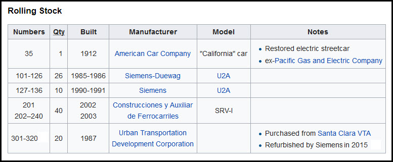
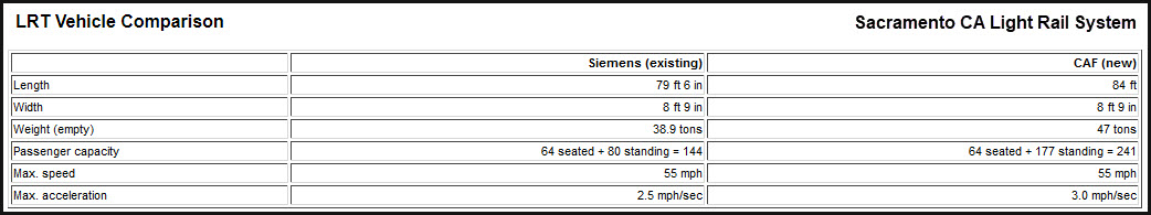
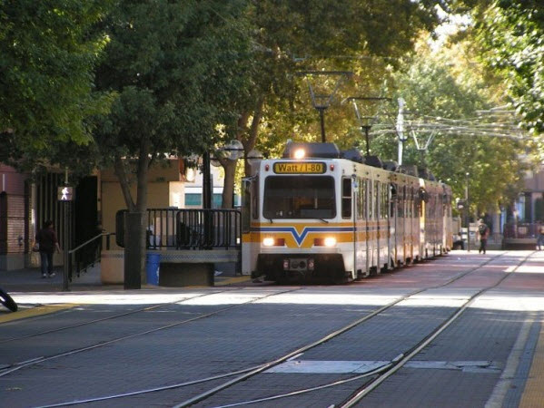
Rolling Stock: The LRV fleet is composed of cars from three different builders: 36 from Siemens-Duewag U2A, some of which have been in use since the RT opened; 40 newer ones delivered in 2003 from Construcciones y Auxiliar de Ferrocarriles, and 20 Urban Transportation Development Corporation cars purchased from Santa Clara Valley Transportation Authority and refurbished by Siemens.
Acknowledgements:
Denver Todd
Websites and other additional information sources of interest for the area:
https://railfanguides.us/ca/sacramento/index.htm
http://www.lightrailnow.org/news/n_sac003.htm
http://www.lightrailnow.org/news/n_sac004.htm
http://www.sacbee.com/news/local/transportation/article31829886.html
http://www.lamar.com/About/NewsandEvents/Lamar-Launches-Sacramento-Light-Rail-Advertising-Program
https://en.wikipedia.org/wiki/Sacramento_RT_Light_Rail
I-5 exit 519 drops you off in the downtown area, near the capitol, and the California State RR Museum.
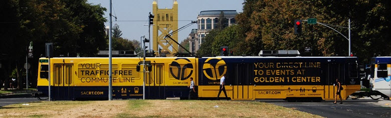 from Lamar Advertising
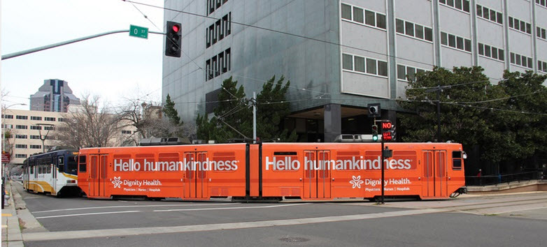 from Lamar Advertising
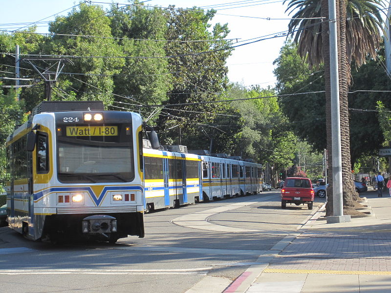
1
The
Disclaimers:
I love trains, and I love signals. I am not an expert. My webpages reflect what I find on the topic of the page. This is something I have fun with while trying to help others.
Please Note: Since the main focus of my two websites is railroad signals, the railfan guides are oriented towards the signal fan being able to locate them. For those of you into the modeling aspect of our hobby, my indexa page has a list of almost everything railroad oriented I can think of to provide you with at least a few pictures to help you detail your pike.
If this is a railfan page, every effort has been made to make sure that the information contained on this map and in this railfan guide is correct. Once in a while, an error may creep in :-)
My philosophy: Pictures and maps are worth a thousand words, especially for railfanning. Text descriptions only get you so far, especially if you get lost or disoriented. Take along good maps.... a GPS is OK to get somewhere, but maps are still better if you get lost! I belong to AAA, which allows you to get local maps for free when you visit the local branches. ADC puts out a nice series of county maps for the Washington DC area, but their state maps do not have the railroads on them. If you can find em, I like the National Geographic map book of the U.S..... good, clear, and concise graphics, and they do a really good job of showing you where tourist type attractions are, although they too lack the railroads. Other notes about specific areas will show up on that page if known.
Aerial shots were taken from either Google or Bing Maps as noted. Screen captures are made with Snagit... a great tool if you have never used it!
By the way, floobydust is a term I picked up 30-40 years ago from a National Semiconductor data book, and means miscellaneous and/or other stuff.
Pictures and additional information is always needed if anyone feels inclined to take 'em, send 'em, and share 'em, or if you have something to add or correct.... credit is always given! Please be NICE!!! Contact info is here
Beware: If used as a source, ANYTHING from Wikipedia must be treated as being possibly being inaccurate, wrong, or not true.
RAILFAN GUIDES HOME
RAILROAD SIGNALS HOME
NEW
01/01/2014, 05/28/2016
Last Modified
16-May-2018