AL
AR
AK
AZ
CA
CO
CT
DC
DE
FL
GA
HI![]()
This site compliments my signal site, ![]()
With a little help from Denver Todd and his Gregarious Railfan website
ID
IL
IN
IA
KS
KY
LA
MA
MD
ME
MI
MN
MO
MS
MT
NE
ND
NH
NJ
NM
NV
NY
NC
OH
OK
OR
PA
PR
RI
SC
SD
TN
TX
UK
UT
VT
VA
WA
WI
WV
WY
CANADA:
AB
BC
MB
NB
NL
NS
ON
PE
QC
SK
FRANCE: Aix en Provence, Grenoble, Paris
ITALY: Ardore
SPAIN:
UNITED KINGDOM: Isle of Wight

System Maps of Various Railroads
Histories
Stations
Towers
Diamond Crossings
Museums & Excursion RR's
Transit Systems
Light Rail Systems
Heavy Rail / Metro / Subway Systems
Commuter Rail
Park & Zoo Trains
Links to other Railfan Guides
Signal Trips
Amtrak's 40th Anniv Train
There are three grade crossings between
trains and streetcars, do you know where they all are?
Amtrak History by Amtrak
Bicentennial and
Patriotic Engines
Beautiful, Unusual, and Odd Trackwork
Ever wonder where LGB Trains used to come from?
The Ringling Brothers 2017 Blue Train, Car by Car
Remember the "failed" TV show from 1979 called Supertrain?
And
here....
I wish I had $25K laying around in 1980 or so when they sold the model! :-) :-)
Note: Most railfans I know are interested in more than just trains. So, I have made an effort to put other things of possible interest to the railfan when visiting the areas the guides cover. These include things like Fire and Police Stations, Museums other than train or transit, bridges, Signals, or just plain old interesting stuff. I am always looking for help, pictures, additional information or corrections, so please do not hesitate to shoot me an email.
If you wonder how I make my make my maps, click here.
My contact info is here.
Both Google Maps and Bing's Maps now have things like restaurants, KMarts, Walmarts, auto stores, and gas stations on their maps. I prefer Bing maps and their Birds Eye view to look for things before I go out, for it is better than the typical satellite view available on both sights. HOWEVER, as of late 2017, they have screwed it up to a fair-thee-well, I mean BIG-TIME, they might as well not even offer the service anymore it sucks so badly.... sorry Bing.... I miss the old ways!..... I sometimes use Google's street level views to augment the birds eye view. If you use Mapquest for directions, just keep in mind that they can sometimes be misleading or take you way out of your way.
http://www.openrailwaymap.org/ Excellent resource, accurate and detailed map of the world showing you current and some abandoned rail lines, with railroad names and a lot of the division/sub-division names!
https://ngmdb.usgs.gov/topoview/ Need a copy of a USGS Topographic Map anywhere from now back to the late 1800's?
https://cnebusiness.geomapguide.ca/ Railroad map by CN Railroad, but has every thing and every railroad on the map!
https://www.philageohistory.org/geohistory/ Historic maps of Philadelphia, overlaid on Google maps (which can be toggled on and off)
http://wx4.org/to/foam/maps/and_timetables1.html Pages and pages of timetables and maps
http://www.city-data.com Don't know what the source of the map imbedded on this page is, but it is interesting - it shows metadata about income, race, and housing costs for everywhere in the U.S.
http://fragis.fra.dot.gov/GISFRASafety/
http://www.openstreetmap.org/
https://www.anyplaceamerica.com/ Interesting website with topographic maps and related pictures and information on just about anywhere in the United States.
https://earth.nullschool.net/ Very cool map of the earth showing winds and other natural phenomena.
https://www.google.com/maps/d/edit?mid=1kmpWX5Sl2XgD3RzUnKgoKRZQPmOabT8&ll=36.31697753190733%2C-80.49968059413692&z=4
https://www.youtube.com/watch?v=M8V8WgOLm8g oooooops, not a map thing, but nevertheless, interesting
Railroad Points of Interest
Railroad Yards
Amtrak Stations, East
Amtrak Stations, West
My MergerMap and some family merger maps
the Akron, Canton & Youngstown RR
the Alaska RR
the Alton RR
Railroad Map of Antarctica
the Atchison, Topeka & Santa Fe RR
the Atlanta & Saint Andrews Bay Rwy
the Atlantic Coast Line RR
the Atlanta & West Point RR
the Aurora, Elgin & Chicago RR
the Austin Western RR
the B&O Akron-Chicago Division/Akron Subdivisions Map
the Baltimore & Eastern RR
the Baltimore & Ohio RR
the Baltimore & Ohio RR Divisions
the Boston & Maine RR
the Buffalo, Rochester & Pittsburgh Rwy
the Burlington, Cedar Rapids & Northern Rwy
the Caney Fork & Western RR
the Central Michigan RR
the Central New England Rwy
the Central Railroad of Georgia
the Central Railroad of New Jersey
the Central Vermont Rwy
the Central Michigan RR
the Charleston, Cincinnati & Chicago RR
the Chesapeake & Ohio Rwy Divisions
the Chessie System
the Chicago, Aurora & Elgin RR
the Chicago Great Western RR
the Chicago, Rock Island & Pacific RR
the Chicago, Terre Haute & Southeastern Rwy
the Chicago & Alton Rwy
the Chicago & Grand Trunk RR
Cincinnati OH
the Cincinnati & Lake Erie RR
the Cotton Belt
the Delaware & Hudson RR
the Delaware, Lackawanna & Western RR
Delaware County PA 1909
the Denver, Rio Grande & Western RR
the De Queen & Eastern RR
the Detroit, Toledo & Ironton RR
the Duluth, Missabe & Iron Range RR
the Duluth, South Shore & Atlantic Rwy
the Duluth, Winnipeg & Pacific Rwy
the East Tennessee & Western North Carolina RR
the Elgin, Joliet & Eastern Rwy
the Erie RR
the Erie-Lackawanna RR
Eugene OR Streetcar System of the 1910's
the Exeter, Hampton & Amesville Street Rwy (Streetcar Line)
the Florida East Coast Rwy
the Fort Dodge, Des Moines & Southern Rwy
the Fox River Valley RR
the Frisco
the Gateway Western Rwy
the Georgia & Florida RR
the Grand River Rwy
the Grand Trunk Western RR
the Great Northern Rwy
the Great Western Rwy of the U.K.
the Grenada RR
the Gulf, Mobile & Northern RR
the Gulf, Mobile & Ohio RR
the Hocking Valley RR
the Illinois Central RR
the Illinois Terminal RR
Indiana State Railroad Map
the Indiana Harbor Belt RR
the Indiana Northeastern RR
Indianapolis IN railroad maps
the Iowa Interstate
the Jackson and Eastern Rwy
the Kankakee, Beaverville & Southern RR
the Kansas City Southern RR
Kansas City Terminal Rwy
the Kansas City, Ft Scott & Memphis RR
the Kansas City, Mexico & Orient Rwy
the Lake Erie & Northern RR
the Lake Shore & Michigan Southern Rwy
the Lancaster, Cecil & Southern RR
the Lehigh & Hudson River RR
the Lehigh Valley RR
the Louisville & Nashville RR
the Maine Central RR
Marquette Rail
the Maryland & Pennsylvania RR
the Milwaukee Road
the Minneapolis & St Louis RR
the Minneapolis, St Paul & Sault St Marie RR (the SOO Line)
the Missouri-Kansas-Texas RR
the Missouri Pacific RR
the Mobile and Ohio RR
the Monon
the Nashville, Chattanooga & St Louis RR
the New Haven RR
New Jersey Railroads in 1887
the New Orleans Great Northern RR
the New York and Long Branch RR
the New York, Chicago and St Louis RR
the New York, Lake Erie & Western RR
the New York, Ontario & Western Rwy
the New York, Susquehanna & Western Rwy
the NKP / Nickel Plate
the Norfolk Southern RR -- This is the NS that was absorbed into the N&W in the early 1970's
the Norfolk & Western Rwy
the Northern Central Rwy
the Northern Pacific RR
the Ohio Central Lines
Ohio Railroads in 1875
the Pacific Electric A transit company in Los Angeles CA
the Penn Central RR
the Pennsylvania RR
the Pennsylvania Turnpike 1952
the Pennsylvania-Reading Seashore Lines
the Pere Marquette
the Philadelphia, Wilmington & Baltimore RR
the Reading RR
the Richmond & Danville RR
the Richmond, Fredericksburg & Potomac RR
the Rio Grande & Pecos Rwy 1882
the Rock Island RR
the Santa Fe
the Savannah & Atlanta RR
the Seaboard Air Line RR
the Seaboard Coast Line RR
the Seaboard & Raleigh Rwy
the Seaboard & Roanoke Rwy
Snowpiercer
the SOO Line RR
the Southern Pacific RR
the Southern Rwy
the St Louis & San Francisco Rwy
the St Louis Southwestern Rwy
the Tennessee Central RR
the Texas, Oklahoma & Eastern RR
the Texas & Pacific Rwy
the Toledo Terminal RR
the Toledo, Wabash & Western RR
the Union Pacific RR
the Virginian Rwy
the Wabash RR
the Western Maryland Rwy
the Williamsport & Elmira RR
Amusement Park Trains and Railroads
Zoo Trains
Department Store, Boardwalk, and other Trains
ALABAMA
Decatur AL:
Railfan Guide
Mini-Railfan Guide a guide by Denver Todd
Flomaton AL: Mini-Railfan Guide a guide by Denver Todd
Irondale AL: Mini-Railfan Guide a guide by Denver Todd
Lineville AL: Mini-Railfan Guide (this guide is for one signal location that no longer exists)
Stevenson AL:
Railfan Guide
Mini-Railfan Guide a guide by Denver Todd
ALASKA
Anchorage AK: Mini-Railfan Guide a guide by Denver Todd
ARIZONA
Flagstaff AZ: Mini-Guide a guide by Denver Todd
Kingman AZ: Mini-Guide a guide by Denver Todd
Tucson AZ: Sunlink Light Rail System Railfan Guide
Wilcox AZ: Mini-Guide a guide by Denver Todd
Winslow AZ: Mini-Guide a guide by Denver Todd
ARKANSAS
Hoxie AR:
Railfan Guide
Mini-Railfan Guide a guide by Denver Todd
Little Rock AR: River Rail Streetcar Line: Railfan Guide
Mammoth Springs AR: Mini-Guide a guide by Denver Todd
Walnut Ridge AR: Railfan Guide
BRITISH COLUMBIA
Vancouver BC:
Skytrain Railfan Guide
West Coast Express Railfan Guide
CALIFORNIA
the Alameda Corridor: Mini-Railfan Guide a guide by Denver Todd
Barstow CA: Railfan Guide
Cajon Pass CA: Mini-Railfan Guide a guide by Denver Todd
Cabazon CA: Mini-Railfan Guide a guide by Denver Todd
Chatsworth CA: Mini-Railfan Guide a guide by Denver Todd
Compton CA - the Alameda Corridor: Mini-Railfan Guide a guide by Denver Todd
Dunsmuir CA: Mini-Railfan Guide a guide by Denver Todd
Escondido CA: Railfan Guide
Feather River Canyon CA: Mini-Railfan Guide a guide by Denver Todd
Fresno CA:
Railfan Guide
Mini-Railfan Guide a guide by Denver Todd
Gaviota Trestle: Mini-Railfan Guide a guide by Denver Todd
Ibis CA: Railfan Guide
Klinefelter (Needles) CA: Mini-Railfan Guide a guide by Denver Todd
Los Angeles CA:
Alameda Corridor a guide by Denver Todd
Transit Home
Metro Transit Rail and Busway Maps
MTA Light Rail System
Union Station Railfan Guide
Needles CA: Railfan Guide
Oakland CA - Jack London Square: Mini-Railfan Guide a guide by Denver Todd
Portola/Feather River Canyon CA: Mini-Railfan Guide a guide by Denver Todd
San Diego CA:
Railfan Guide
San Diego Trolley
Sacramento CA:
Railfan Guide
Sacramento Light Rail Guide
the California State Railroad Museum
San Francisco CA:
BART (Heavy Rail)
Cable Cars
Cable Cars a guide by Denver Todd
CalTrain (Commuter Service)
MUNI Trackless Trolleys/Electric Busses
MUNI Streetcars
Streetcar/Train Crossing A page covering all three streetcar/train crossings in the U.S., including the one here in San Francisco
San Jose CA:
VTA Light Rail System guide
ACE - Altamont Commuter Express
Tehachapi CA: Tehachapi Depot Historical Museum
Tehachapi Loop CA: Railfan Guide
Truckee CA: Mini-Railfan Guide a guide by Denver Todd
COLORADO
Denver CO: RTD Light Rail System guide
Georgetown Loop CO: Mini-Railfan Guide a guide by Denver Todd
Lyons CO: Mini-Railfan Guide all this just for one depot!?
Moffat Tunnel: Mini-Railfan Guide a guide by Denver Todd
CONNECTICUT
Cos Cob CT: Railfan Guide
New Haven CT: Railfan Guide
Old Saybrook CT:
Railfan Guide
Mini-Railfan Guide a guide by Denver Todd
Stamford CT: Mini-Railfan Guide
D.C.
Click here for Washington D.C.
DELAWARE
Greenbank DE: Wilmington and Western RR
Newark DE: Railfan Guide
Wilmington DE:
Map 1 ..... Wilmington Railfan Guide Homepage
Map 2 ..... Downtown
Map 3 ..... East Side - Amtrak's Wilmington Shops & NS's Edgemoor Yard
Map 4 ..... West Side - CSX's Wilsmere Yard and the Wilmington & Western RR
Map 5 ..... South Side - Mostly Local Switching
FLORIDA
Jacksonville FL:
Jacksonville Home Page
Union Station Railfan Guide
chasing the Talleyrand Terminal Railroad
the CSX Business Train
the Westside South / CSX
the Eastside South / FEC
the Skyway Monorail
Lee FL: Mini-Railfan Guide
Miami FL:
Brightline High Speed Regional Rail
TriRail Regional Commuter Service
Miami Metro
MIA Mover: Service at the Miami Airport
Marcy FL: Mini-Railfan Guide (this guide is for one lonely diamond in the middle of no-where :-)
Plant City FL: Mini-Guide a guide by Denver Todd
Sanford FL: Railfan Guide
Tampa: Streetcar/Train Crossing A page covering all three streetcar/train crossings in the U.S., including the one here in Tampa
FRANCE
Aix en Provence FR: Railfan Guide
Aubagne FR: Railfan and Tram Guide
Grenoble FR: Grenoble Light Rail
Nancy FR: the Nancy Guided Light Transit / TVR System
Paris FR:
The Train Stations of Paris
Paris Metro
Paris Long Distance Train Service/SNCF
RER Regional Commuter Rail Service
Paris Trams
Eurostar Service - London to Paris and Brussels
The Eiffel Tower
France:
SNCF: France's National Network
TGV's: The High Speed Trains of the SNCF
GEORGIA
Atlanta GA:
Map 1 ..... the Atlanta Homepage
Map 2 ..... Downtown Atlanta
Map 3 ..... NS's Inman yard and CSX's Tilford & Howell Yards - NW of downtown Atlanta
Map 4 ..... south of Atlanta
Map 5 ..... east of Atlanta
Map 6 ..... west of Atlanta
Map 7 ..... the Duluth area, with the Southeast Railroad Museum and the Duluth depot
Map 8 ..... the Marietta and Elizabeth area - NW outside the Perimeter
Map 9 ..... Guide to the Georgia Northeastern RR
Map 10 ..... the Kennesaw area & the Southern Museum of Civil War and Locomotive History
Map 11 ..... the Norcross area and the Norcross depot
Map 12 ..... the Doraville area, NS yard and the end of the MARTA NE line
MARTA Metro System guide
Austell GA: Mini-Railfan Guide a guide by Denver Todd
Dalton GA: Mini-Railfan Guide a guide by Denver Todd
Doraville GA: Railfan Guide part of the Atlanta Guide series
Duluth GA: Railfan Guide part of the Atlanta Guide series
Elizabeth GA: Railfan Guide where the GA NE RR is located, next to Marietta, part of the Atlanta Guide series
Folkston GA:
Railfan Guide
Mini-Railfan Guide a guide by Denver Todd
Jesup GA: Mini-Railfan Guide a guide by Denver Todd
Kennesaw GA: Railfan Guide part of the Atlanta Guide series
Locust Grove GA: Mini-Railfan Guide a guide by Denver Todd
Manchester GA: Mini-Railfan Guide a guide by Denver Todd
Marietta GA: Railfan Guide part of the Atlanta Guide series
Norcross GA: Railfan Guide part of the Atlanta Guide series
Ringgold GA: Mini-Railfan Guide a guide by Denver Todd
Savannah GA: Railfan Guide
HAWAII
We have nothing.....
IDAHO
Sandpoint ID: Mini-Railfan Guide a guide by Denver Todd
ILLINOIS
Aurora IL:
Railfan Guide
Mini-Railfan Guide a guide by Denver Todd
Berwyn IL (Lavergne METRA Station): Mini-Railfan Guide a guide by Denver Todd
Blue Island IL:
Railfan Guide
Mini-Railfan Guide a guide by Denver Todd
BNSF Racetrack - Chicago IL: Mini-Railfan Guide a guide by Denver Todd
Centralia IL: Mini-Railfan Guide a guide by Denver Todd
Cary IL: Mini-Railfan Guide a guide by Denver Todd
Chicago IL:
Chicago Railfan Guide Homepage
Hotspots
Crossings & Junctions
Stations
Yards
Towers
Railroads
Interlocking Diagrams
Amtrak Amtrak train service in and out of the Chicago area
Metra Commuter Rail (map and basic info only & The BNSF Racetrack)
CTA El and Subway System (map and basic info only)
Specific Chicago area towns:
Aurora IL
Blue Island IL
Dolton IL
Joliet IL
Chicago Mini-Railfan Guides by Denver Todd:
Blue Island
BNSF Racetrack
(Chicago) Clyburn Station
(Chicago) Union Station
(Chicago) Roosevelt Road Overpass
West Chicago
Dolton IL:
Railfan Guide
Mini-Guide A 360 video view a guide by Denver Todd
Edelstein IL: Mini-Railfan Guide a guide by Denver Todd
Effingham IL: Railfan Guide
Elmhurst IL:
Railfan Guide
Mini-Railfan Guide a guide by Denver Todd
Franklin Park IL: Mini-Railfan Guide a guide by Denver Todd
Galesburg IL: Mini Guide a guide by Denver Todd
Homewood IL: Railfan Guide A 360 video view a guide by Denver Todd
Joliet IL:
Railfan Guide
Union Station Mini-Railfan Guide a guide by Denver Todd
LaGrange IL: Mini-Railfan Guide a guide by Denver Todd
Lake Bluff IL - Rondout Junction: Mini-Railfan Guide a guide by Denver Todd
Matteson IL:
Railfan Guide
Mini-Railfan Guide a guide by Denver Todd
Rochelle IL:
Railfan Guide
Mini-Railfan Guide A 360 video view a guide by Denver Todd
Rondout Junction - Lake Bluff IL: Mini-Railfan Guide a guide by Denver Todd
Savanna IL: Mini-Railfan Guide a guide by Denver Todd - on the BNSF NW of Chicago
Streator IL: Mini-Railfan Guide a guide by Denver Todd - on the BNSF NW of Chicago
Tuscola IL: Mini-Railfan Guide a guide by Denver Todd - on the BNSF NW of Chicago
Union IL:
Railfan Guide
Mini-Railfan Guide a guide by Denver Todd
West Chicago IL: Mini-Railfan Guide a guide by Denver Todd - on the BNSF NW of Chicago
Western Springs IL: Mini-Railfan Guide a guide by Denver Todd - on BNSF's Racetrack
INDIANA
Brownstown IN: A brief mention on the Seymour Page
Chesterton IN - Porter Junction: Mini-Railfan Guide a guide by Denver Todd
Elkhart IN:
Railfan Guide - home of the National NYC RR Museum PDF Version
Mini-Railfan Guide a guide by Denver Todd
Frankfort IN:
Railfan Guide
Mini-Railfan Guide a guide by Denver Todd
Gary IN: Mini-Railfan Guide a guide by Denver Todd
Griffith IN:
Railfan Guide
Mini-Railfan Guide a guide by Denver Todd
Haley Tower - Terre Haute IN: Railfan Guide
Hamlet IN: Mini-Railfan Guide
Hanna IN: Railfan Guide a quick little guide for signals only at a quiet little diamond
Indianapolis IN:
Railfan Guide Homepage
Map 1 - West
Map 2 - Downtown
Map 3 - East
Kokomo IN: Railfan Guide
Lafayette IN: Mini-Railfan Guide a guide by Denver Todd
Linden IN: Linden Railroad Museum Railfan Guide
Michigan City IN:
Railfan Guide - home to the Chicago, South Shore & South Bend RR & the NICTD Commuter line
Mini-Railfan Guide a guide by Denver Todd
Norman IN: A brief mention on the Seymour Page
North Vernon IN: Railfan Guide
Ogden Dunes IN: Mini-Railfan Guide a guide by Denver Todd
Portage IN - Willow Creek Junction: Mini-Railfan Guide a guide by Denver Todd
Seymour IN: Railfan Guide
South Bend IN: Railfan Guide
Sparksville IN: A brief mention on the Seymour Page
Terre Haute IN:
Haley Tower
Mini-Railfan Guide a guide by Denver Todd
Union Mills (Wellsboro) IN: Mini-Railfan Guide a guide by Denver Todd
Vallonia IN: A brief mention on the Seymour Page
Valparaiso IN: Railfan Guide
Willow Creek Junction (Portage IN): Mini-Railfan Guide a guide by Denver Todd
IOWA
Boone IA: Mini-Railfan Guide a guide by Denver Todd
Clinton IA: Mini-Railfan Guide a guide by Denver Todd
Davenport IA: Mini-Railfan Guide a guide by Denver Todd
Manly IA: Railfan Guide
Mason City IA:
Railfan Guide includes the diamonds between the UP and the Iowa Traction and IC&E
Mini-Railfan Guide a guide by Denver Todd
Nora Springs IA: Railfan Guide
ITALY
Ardore, Calabria IT: Mini-Railfan Guide
KANSAS
Kansas City KS
Kansas City Terminal Rwy Map
Santa Fe Junction Railfan Guide
Topeka KS: Mini-Railfan Guide a guide by Denver Todd
KENTUCKY
Burnside Bridge KY: Mini-Railfan Guide a guide by Denver Todd
La Grange KY:
Railfan Guide Street Running!
Mini-Railfan Guide a guide by Denver Todd
NS's Rat Hole: Mini-Railfan Guide a guide by Denver Todd
Walton KY: Railfan Guide
LOUISIANA
New Orleans LA: Streetcar Guide
Slidell LA (Lake Ponchatrain): Mini-Railfan Guide a guide by Denver Todd
MAINE
Portland ME: Railfan Guide
MARYLAND
• Maryland Transit:
- Baltimore Light Rail and Metro Map
- The Suburban Maryland Purple Line
- the Baltimore Metro Subway System
--- Stations of the Baltimore Metro System
- MARC Brunswick Line
- MARC Camden Line
--- Camden Station (part of the map 12 page)
--- St Denis Station (Elkridge MD)(part of the map 6 page)
--- Dorsey MD
--- Jessup MD
--- Savage Station (Annapolis Junction MD)
--- Laurel Racetrack
--- Laurel
--- Muirkirk Station (Beltsville MD)
--- Greenbelt
--- College Park
--- Riverdale
--- DC Union Station
- MARC Penn Line North
- MARC Penn Line South
- The Baltimore Red Line
- The Maglev Project (an opinion page)
- Baltimore Streetcar Museum
- The Baltimore Light Rail System Introduction
--- The North Avenue and Cromwell Shop Facilities
--- Signals of the Baltimore Light Rail System
--- Operating Rules of the Baltimore Light Rail System
--- Stations of the Baltimore Light Rail System
- Hunt Valley to Lutherville
- Lutherville to North Avenue
- North Avenue to Westport
- Westport to Cromwell
- Penn Station & BWI
--- Misc Early Pictures of the Baltimore Light Rail System
--- Support Equipment for the Baltimore Light Rail System
- Signs
- Poles and Catenary
- Substations
- Track & Switches
--- How the Baltimore LRV's Work (Techincal Discussion)
--- Problems With the Baltimore Light Rail System (Editorial/bad language)
- Towson "The Loop" Free Bus Service in Towson MD
• Maryland Railroads / Past and Present:
- Amtrak
- CSX
- Norfolk Southern
- the Canton RR
- Western Maryland RR
- the Maryland Midland RR
- the Walkersville Southern RR
- the Lancaster, Cecil & Southern RR
We're going to do Baltimore first, since it is covered in the most detail... following all of the Baltimore sections, everything else is covered alphabetically....
• Baltimore MD:
Baltimore Railfan Guide Homepage
Baltimore Railfan Maps Index Page
Mini-Railfan Guide a guide by Denver Todd
Fire and Police Stations of Baltimore County
Baltimore Railroad Radio Internet Feed via Broadcastify
• Baltimore - Tunnels:
Amtrak's B&P Tunnel
CSX's Howard St Tunnel
• Baltimore - Area Train Accidents:
CSX Retaining Wall Collapse -- 2014
CSX Coal Train Derailment in Ellicott City -- 2012
CSX Derailment in Rosedale -- 2013
CSX Howard Street Tunnel Derailment -- 2016
CSX Derailment at the Baltimore Streetcar Museum -- March 2019
Light Rail Sinkhole -- July 2019
Small Amtrak MOW Derailment -- July 2019
CSX Howard Street Tunnel Derailment -- 2019 (note, this and the other two in July 2019 all happened in the same week!!!)
• Baltimore - General Guide Maps:
Highway Guide to Baltimore
Hotel Guide to Baltimore
Towns Around Baltimore with Railroad Related Things to See
Major Rail Lines, Yards and Stations
Little Italy and Greektown Dining
• Baltimore - Museums:
B&O Railroad Museum Baltimore MD
Baltimore Streetcar Museum Baltimore MD
Ellicott City B&O RR Museum Ellicott City MD
• Baltimore Area Diamond Crossings
Pennsy and B&O (CSX/NS) crossing at Penn Mary Yard - Canton area
B&O crossing the Pennsy - Canton area
• Baltimore Area Railfan Maps:
Map 1 ..... North Suburbs - Towson / Lutherville / Timonium / Cockeysville
Map 2 ..... NW Suburbs - Pikesville / Owings Mills / Reisterstown
Map 3 ..... NE Suburbs - Whitemarsh / Martin State
Map 4 ..... North Baltimore City
Map 5 ..... North Central Baltimore City - Penn Station Area
Map 6 ..... West Suburbs - Catonsville / Elkridge / Thomas Viaduct
Map 7 ..... SW Baltimore City to the Suburbs
Map 8 ..... South Suburbs - Mostly CSX Yards
Map 9 ..... SE Suburbs - the Sparrow Point area
Map 10 .... East Baltimore City - Highlandtown and Canton, NS's Canton Yard & CSX's Penn-Mary Yard
Map 11 .... East Baltimore City - CSX and NS's Bayview Yards
Map 12 .... Downtown Baltimore City - CSX's Bailey's Wye & the B&O Transportation Museum
Map 13 .... West Baltimore City - CSX Mt Winans Yard & Zepp's Bridge
Map 14 .... SE Downtown Baltimore - CSX's Riverside & Locust Point Yards
Map 15 .... NW Baltimore - Following the WM & Metro out of town
Map 16 .... SW Suburbs - Glen Burnie / Ferndale / BWI
Map 17 .... West of Baltimore - the Old Main Line - Ellicott City to Sykesville
• Baltimore - Historic in Nature:
the Greenspring Branch
B&O Map of the central to southern Baltimore City tracks (Map not one of mine - copied from elsewhere)
Striegel's Baltimore Locomotive Recycler from days of yore....
• Baltimore City Locations Listed Alphabetically...
Bailey's Wye / Baltimore City MD: Railfan Guide, Map 12 Map 14 (just barely shows the wye)
Baltimore Highlands/Baltimore City MD: Map 7 Map 8
Bayview Yards area/Baltimore City MD: Map 10 Map 11
B&O Train Museum area/Baltimore City MD: Map 12
Boston St area/Baltimore City MD: Map 10
Brooklyn MD/Baltimore City: Map 8
Camden Station area/Baltimore City: Map 12
Canton/Baltimore City: Map 10
Central Business District of Baltimore City: Map 5
Curtis Bay/Baltimore City: Map 8
Fort McHenry area/Baltimore City: Map 14
Fulton Junction area/Baltimore City MD: Map 15 -- Pennsy Wye, very bad area
Greektown area/Baltimore City: Map 10
Gwynn Tower area/Baltimore City: Map 15
Hamburg St/Baltimore City: Map 14
Hamden/Baltimore City: Map 4
Highlandtown/Baltimore City: Map 10
Little Italy area/Baltimore City: Map 5 -- Dining
Locust Point/Baltimore City: Map 14
Mondawmin area/Baltimore City: Map 15 -- Metro/subway and WM/CSX
Milford Mill Rd area/Baltimore City: Map 15 -- Metro/subway and WM/CSX
Mt Royal area/Baltimore City: Map 5
Mt Washington/Baltimore City: Map 4 -- Light rail stop
Mt Winans Yard area/Baltimore City: Map 7 Map 13 -- Detail map of the area
North Ave/Baltimore City Map 4
North Linthicum/Baltimore City: Map 7 Map 16
Penn Mary area/Baltimore City: Map 10
Penn Station area/Baltimore City: Map 5
Port Covington/Baltimore City: Map 14 Map 8
Reisterstown Plaza area/Baltimore City: Map 15 -- Metro/subway, bus yard, Metro shops, and WM/CSX
Riverside Yard area/Baltimore City: Map 14
South Baltimore City: Map 8
(Sports) Stadium area/Baltimore City: Map 12
Westport/Baltimore City: Map 7 Map 8
Zepp's Bridge/Mt Winans Yard area/Baltimore City: Map 7 Map 13 -- Detail map of the area
• Baltimore County Locations Listed Alphabetically...
Arbutus MD/Baltimore Cnty: Map 6 Map 7
Catonsville MD/Baltimore Cnty: Map 6
Cockeysville MD/Baltimore Cnty: Railfan Guide
Dundalk MD/Baltimore Cnty: Map 9
Eastpoint MD/Baltimore Cnty: Map 9
Elkridge MD/Baltimore Cnty: Map 6 -- Thomas Viaduct
Garrison MD/Baltimore Cnty: Map 2
Glencoe MD/Baltimore Cnty: Railfan Guide
Glyndon MD/Baltimore Cnty: Map 2
Halethorpe MD/Baltimore Cnty: Map 6 Map 7
Hereford MD/Baltimore Cnty: Map 1 -- No train stuff, only the Hereford Volunteer Fire Co and the Hereford Ambulance Co
Hunt Valley MD/Baltimore Cnty: Railfan Guide
Lutherville MD/Baltimore Cnty: Railfan Guide Map 1
Martin State MD/Baltimore Cnty: Map 3
Monkton MD/Baltimore Cnty: Railfan Guide Map 1
Northpoint MD/Baltimore Cnty: Map 9
Owings Mills MD/Baltimore Cnty: Map 2
Pikesville MD/Baltimore Cnty: Map 2 Map 15 -- Metro/subway and WM/CSX
Putty Hill MD/Baltimore Cnty: Map 3 -- Fire stuff only
Reisterstown MD/Baltimore Cnty: Map 2
Relay MD/Baltimore Cnty -- Thomas Viaduct: Mini-Railfan Guide a guide by Denver Todd
Riderwood MD/Baltimore Cnty: Railfan Guide -- The Ruxton and Riderwood section of Map #1
Rosedale MD/Baltimore Cnty: Map 3
Ruxton/Riderwood MD/Baltimore Cnty: Railfan Guide -- The Ruxton and Riderwood section of Map #1
Sparrows Point MD/Baltimore Cnty: Map 9
Stemmers Run MD/Baltimore Cnty: Map 3 -- former PRR depot
Stevenson MD/Baltimore Cnty: Map 1 -- Former PRR Depot
St Denis MD/Baltimore Cnty: Map 6 Map 16 -- MARC station
Texas MD/Baltimore Cnty: Railfan Guide
Timonium MD/Baltimore Cnty: Railfan Guide Map 1
Towson MD/Baltimore Cnty: Railfan Guide -- The Towson only part of Map #1
Whitemarsh MD/Baltimore Cnty: Map 3
Woodlawn MD/Baltimore Cnty: Map 6
• Maryland Towns / Cities/ Areas Listed Alphabetically...
Aberdeen MD: Railfan Guide -- south of Havre de Grace and Perryville - ex B&O depot and MARC station
Annapolis Junction MD: Railfan Guide -- ~35 min south of downtown Baltimore (off I95)
Annapolis MD: Railfan Guide -- Nothing here railroad related anymore, but it is the capitol of Maryland and home to the US Naval Academy!
Bethesda MD: Purple Line Railfan Guide
Bowie to New Carrolton MD: Railfan Guide -- Amtrak's NEC, MARC, the end of the Orange Metro line, and the Bowie RR Musuem
Brunswick MD: Railfan Guide -- CSX yard, museum, MARC engine storage
BWI Airport area MD: Map 6 Map 16
Capitol Beltway MD: Picture Collection -- A collection of pictures by Jim Nowotarski from the station in the 70's
Chesapeake Beach MD: Railfan Guide -- Home of the Chesapeake Beach Rwy Museum -- Way south of Baltimore
Colesville MD: Railfan & Museum Guide -- Home to the National Capitol Trolley Museum
College Park MD: Railfan Guide
Cromwell/Glen Burnie MD/Anne Arundel Cnty: Map 16 -- End of line for light rail, shops
Dorsey MD: Railfan Guide
Ellicott City MD/Howard Cnty: Map 6
Ferndale MD/Anne Arundel Cnty: Map 16
Frederick MD: Railfan Guide -- MARC station and yard, wye, many historic buildings
Gaithersburg MD/Montgomery Cnty: Railfan Guide
Glen Burnie MD/Anne Arundel Cnty: Map 16
Hagerstown MD: Railfan Guide -- CSX (former WM) yard, NS (former N&W) yard, steam engine on display in park, Museum
Hampstead MD: Railfan Guide -- Way north of Baltimore, ex WM depot
Havre de Grace MD: Railfan Guide -- Between Perryville and Aberdeen, western shore of the Susquehanna
Hyattsville MD: Railfan Guide -- CSX's JD "Tower" Wye - NE suburban Washington DC
Ilchester MD/Howard Cnty: Map 6
Jessup MD: Railfan Guide
Laurel MD: Railfan Guide
Linthicum MD/Anne Arundel Cnty: Map 8 Map 7 Map 16
Mt Airy MD: Railfan Guide -- Tunnel on the Old Main Line, vintage depot
Odenton to Bowie MD: Railfan Guide -- Amtrak's NEC and MARC service
Perryville MD:
Railfan Guide -- NE of Baltimore on the Susquehanna River - CSX, Amtrak NEC, and MARC
Mini-Railfan Guide a guide by Denver Todd
Point of Rocks MD:
Point of Rocks MD
Mini-Railfan Guide a guide by Denver Todd
Riverdale MD: Railfan Guide
Savage MD: Railfan Guide (part of the Annapolis Junction MD page)
Savage MD: A guide to the Bollman Truss Bridge:
Railfan Guide
Mini-Railfan Guide a guide by Denver Todd
Suburban MD: Purple Line Railfan Guide
Sykesville MD:
Sykesville MD -- Way west of Baltimore
Mini-Railfan Guide a guide by Denver Todd
Union Bridge MD: Western Maryland Rwy Historical Society Museum
Blue links are to pages on that city, green links are to maps where the city or area is part of a larger map.
• Central Maryland series:
Central MD Index Page
Boyce and Berryville VA
Brunswick MD
Frederick MD
Hagerstown MD
Harpers Ferry WV
Mt Airy MD
Point of Rocks MD
MASSACHUSETTS
Boston MA:
MBTA Light & Heavy Rail (just maps so far)
the Mattapan High Speed Trolley Line
Bourne MA - Cape Cod Canal Railroad Bridge: Mini-Railfan Guide a guide by Denver Todd
Springfield MA: Railfan Guide
Waltham MA: Railfan Guide
MICHIGAN
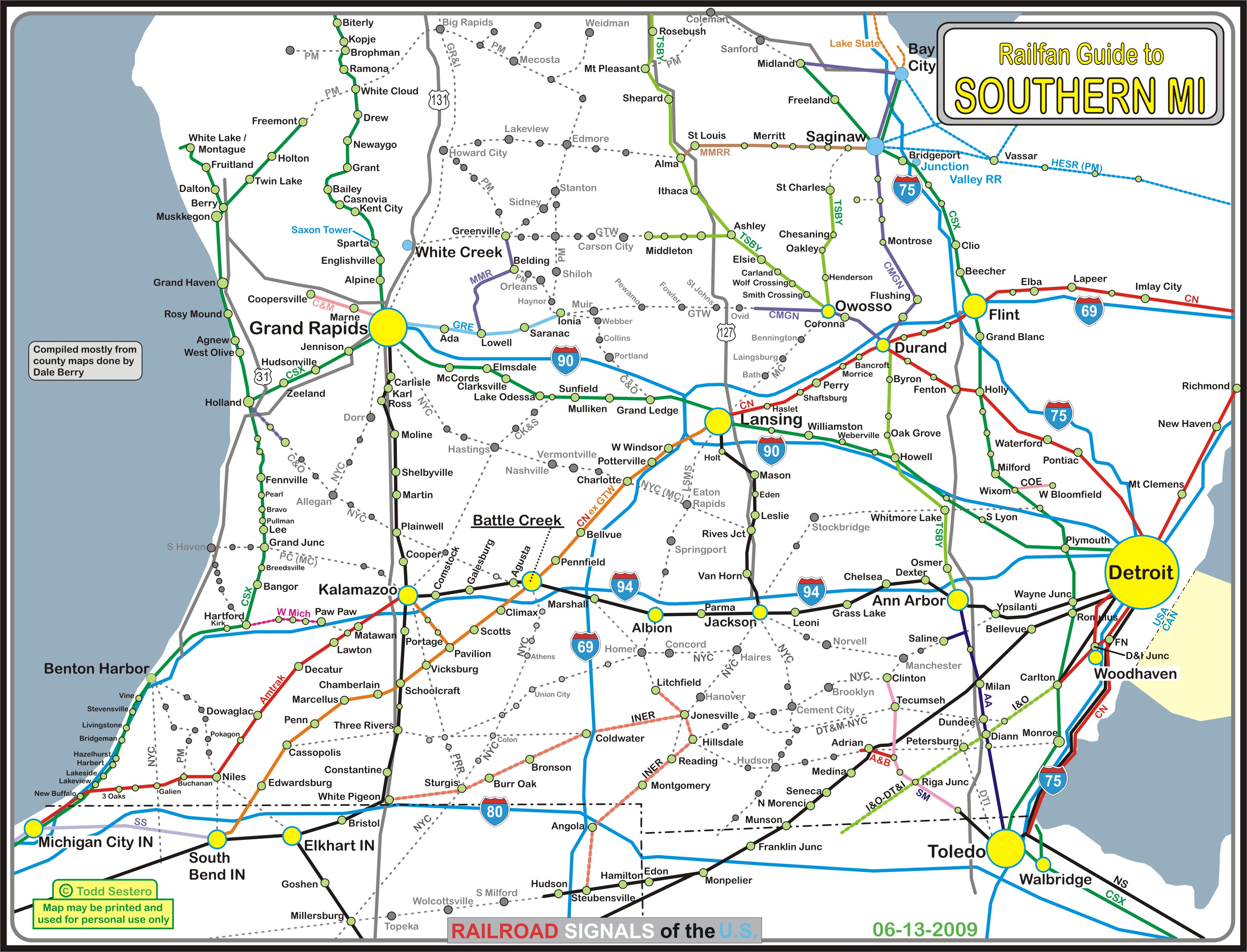
Southern MI Railfan Guide Homepage
Albion MI: Railfan Guide
Alma to Owosso to Durand MI Railfan Chase Maps
Note: the three maps that covered Alma to Owosso, and Owosso to Durand are now on this one page
Ann Arbor MI: Railfan Guide
Battle Creek MI:
Railfan Guide
Mini-Railfan Guide a guide by Denver Todd
Bay City MI: Railfan Guide
Bridgeport MI and the Junction Valley RR: Railfan Guide
Cadillac MI: Railfan Guide
Coopersville MI: Railfan Guide
Delray (Detroit) MI:
See Below under Detroit
Detroit MI and the Detroit area:
Detroit Railfan Guide Homepage
Map 1 - SouthWest Detroit Railfan Guide
Map 1a - Railroad Bridges in SouthWest Detroit
Map 2 - Dearborn Area Railfan Guide
Map 3 - Ferndale/Royal Oak Railfan Guide
Map 4 - Downtown Detroit/Union Station Railfan Guide
Map 5 - Delray Tower Railfan Guide
the QLine Streetcar System
the People Mover in Downtown Detroit
Flatrock/Woodhaven area Railfan Guide
Plymouth Diamond area Railfan Guide
Wyandotte area Railfan Guide
Plymouth Mini-Railfan Guide a guide by Denver Todd
Delray Mini-Railfan Guide a guide by Denver Todd
Train Station's of Detroit
Durand MI:
Railfan Guide
Mini-Railfan Guide a guide by Denver Todd
Ferndale MI Ferndale/Royal Oak Railfan Guide
Flatrock/Woodhaven MI: Railfan Guide
Flint MI: Railfan Guide
Grand Haven MI:
Railfan Guide
Mini-Railfan Guide a guide of his home town by Denver Todd
Grand Rapids MI: Railfan Guide
Grayling MI: Railfan Guide
Jackson MI: Railfan Guide
Kalamazoo MI:
Railfan Guide
Mini-Railfan Guide a guide by Denver Todd
Kalkaska MI: Railfan Guide
Lansing MI:
Railfan Guide
Trowbridge Mini-Railfan Guide a guide by Denver Todd
Marshall MI: the Mid-Michigan Railroad Club Guide
Mt Pleasant MI: Mini-Railfan Guide
Owosso MI: Railfan Guide
Plymouth MI:
Plymouth Diamond Railfan Guide
Plymouth Mini-Railfan Guide a guide by Denver Todd
Royal Oak MI Ferndale/Royal Oak Railfan Guide
Saginaw MI: Railfan Guide
Suttons Bay MI: Railfan Guide
Traverse City MI: Railfan Guide
White Creek RR: Live Steam Railfan Guide
Woodhaven MI: Flatrock & Woodhaven Railfan Guide
Wyandotte MI: Railfan Guide
Rail Lines of Southern Michigan (1.5meg JPEG)
MINNESOTA
Albert Lea MN Railfan Guide
Minneapolis MN
Minneapolis Homepage
Map 1 - Northtown, Humbolt, and Shoreham yard areas
Minneapolis/St Paul Light Rail Guide
-- Metro Blue Line Guide
-- Metro Green Line Guide
-- Southwest Expansion Guide
Northstar Commuter Service
Minnesota Streetcar Museum - Como Harriet Line
New Brighton MN Railfan Guide
Northwest of St Cloud MN: BNSF Chase Map
St Paul:
St Paul Homepage
Map 1 - the CP's St Paul (Pigs Eye) Yard, UP's Hoffman Yard & the Dayton Bluff area
Map 2 - Downtown St Paul: Union Depot, the Minnesota Transportation Museum, Wye's, etc
Mini-Railfan Guide a guide by Denver Todd
MISSISSIPPI
Grenada MS: Railfan Guide
Jackson MS: Railfan Guide
Magnolia MS: Railfan Guide
Vaughan MS: Railfan Guide
MISSOURI
Birmingham MO: Mini-Railfan Guide a guide by Denver Todd
Kansas City MO: Mini-Railfan Guide a video 360 view a guide by Denver Todd
Kirkwood (St Louis) MO: Mini-Railfan Guide a guide by Denver Todd
La Plata MO: Mini-Railfan Guide a guide by Denver Todd
Marceline MO: Mini-Railfan Guide a guide by Denver Todd
Pacific MO: Mini-Railfan Guide a guide by Denver Todd
St Louis MO:
Metro Light Rail System Map
Mini-Railfan Guide a guide by Denver Todd
MONTANA
Nothing to report yet....
NEBRASKA
Blair Bridge NE: Mini-Railfan Guide a guide by Denver Todd, we forgot to save this one, so the page is on "the Wayback Machine" website....
Brady NE: Mini-Railfan Guide a guide by Denver Todd
Crawford Hill NE: Mini-Railfan Guide a guide by Denver Todd
Gibbon NE: Mini-Railfan Guide a guide by Denver Todd
Grand Island NE: Mini-Railfan Guide a guide by Denver Todd
North Platte NE: Mini-Railfan Guide a guide by Denver Todd
Omaha NE - Missouri River Bridge: Mini-Railfan Guide a guide by Denver Todd, we forgot to save this one too, so the page is on "the Wayback Machine" website....
Sutherland NE:
Railfan Guide
Mini-Railfan Guide a guide by Denver Todd
NEW HAMPSHIRE
Dover NH: Railfan Guide
NEW JERSEY
Bordentown NJ: Railfan Guide
Camden/Trenton NJ: NJT's River Line Light Rail
Camden/Lindenwold NJ: PATCO High Speed Line
Harrison NJ: Railfan Guide
Manunka Chunk NJ: Railfan Guide
Newark NJ: Railfan and Newark Subway Light Rail guide
New York/New Jersey: PATH Rail System
NEVADA
Winnemucca NV: Railfan Guide
NEW MEXICO
Belen NM: Mini-Railfan Guide a guide by Denver Todd
Lordsburg NM: Railfan Guide
NEW YORK
Batavia NY: Railfan Guide
Batavia to Depew NY: Chase Guide
Bear Mountain Bridge NY: Mini-Railfan Guide a guide by Denver Todd
Binghamton NY:
Binghamton Railfan Guide Homepage
Map 1 ..... Downtown Binghamton
Map 2 ..... East and South of Binghamton
Map 3 ..... West of Binghamton
Map 4 ..... North of Binghamton
Buffalo NY:
Buffalo Railfan Guide Homepage
Map 1 ..... Downtown Buffalo
Map 2 ..... East - CSX's Frontier Yard & NS's Bison Yard
Map 3 ..... Seneca
Map 4 ..... South
Map 5 ..... North
Light Rail guide
Depew NY: Railfan Guide
Elmira NY: Railfan Guide
New York City NY:
New York City Homepage
AirTrain system to JFK Airport
Hell Gate Bridge
Jamaica Station
Penn Station to New Rochelle NY Signal Tour
Queens Homepage
Sunnyside Yard
Woodside (Sunnyside to Jamaica)
Staten Island Homepage
SIRT Railfan Guide
New York/New Jersey: PATH Rail System
New York City NY: A scan of part of map of New York City (~mid 40's) - showing the railroads and associated piers - great stuff!
West Henrietta NY: NY Museum of Transportation
Williamsville: the Western New York Railway Society Museum dedicated to the Lehigh Valley RR in the former LV Williamsville Depot
NORTH CAROLINA
Charlotte NC: Lynx Light Rail Guide
Hamlet NC: Mini-Railfan Guide a guide by Denver Todd
Henderson NC: Railfan Guide
Gastonia NC: Railfan Guide
Grover NC: Railfan Guide
Raleigh NC: Railfan Guide
Spencer and Salisbury NC: Railfan Guide
Thomasville NC: Mini-Railfan Guide a guide by Denver Todd
NORTH DAKOTA
Minot ND: Railfan Guide
OHIO
Bellevue OH:
Railfan Guide
Mini-Railfan Guide a guide by Denver Todd
Berea OH:
Railfan Guide - Premier railfan spot with both CSX and NS running by
Mini-Railfan Guide a guide by Denver Todd
Cincinnati OH:
Google Oriented Railmap Don't know who took the time to do this, but thanks to whomever it is!.....
Cincinnati Streetcar: Railfan Guide
Cincinnati Union Terminal: Mini-Railfan Guide a 360 video view a guide by Denver Todd
Conneaut OH: Mini-Railfan Guide a guide by Denver Todd
Crestline OH: Railfan Guide
Deshler OH:
Railfan Guide
Mini-Railfan Guide a guide by Denver Todd
Dover OH: Mini-Railfan Guide a guide by Denver Todd
Fostoria OH:
Railfan Guide PDF Map
Mini-Railfan Guide a guide by Denver Todd
Glendale OH:
Railfan Guide
Mini-Railfan Guide a guide by Denver Todd
Hamler OH: Railfan Guide
Lima OH: Mini-Railfan Guide a guide by Denver Todd
Mansfield OH: Railfan Guide ... new May2020!
Marion OH:
Railfan Guide
Mini-Railfan Guide a guide by Denver Todd
North Baltimore OH: Railfan Guide
Toledo OH:
Toledo Railfan Guide Homepage
Map 1 - Toledo north
Map 2 - Toledo south
Map 3 - Toledo northeast - East side of the Maumee and north of Walbridge
Mini-Railfan Guide a guide by Denver Todd
Vermilion OH: Mini-Railfan Guide a guide by Denver Todd
Walbridge OH:
CSX Yards map PDF Map
Mini-Railfan Guide a guide by Denver Todd
OKLAHOMA
Vinita OK: Railfan Guide
Waynoka OK: Railfan Guide
ONTARIO
Guelph: Railfan Guide of Sorts (it's for the Radial Railway Museum, but it includes sights in Guelph)
Ottawa ON:
O-Train Trillium Light Rail
O-Train Confederation Light Rail
Confederation Light Rail Extensions
Toronto ON:
TTC Streetcar Guide
Union Pearson Express Guide
OREGON
the Columbia River Gorge: Mini-Railfan Guide a guide by Denver Todd
Klamath Falls OR: Mini-Railfan Guide a guide by Denver Todd
Portland OR:
Portland Railfan Guide Homepage
Map 1 ..... The Amtrak Station Area
Map 2 ..... UP's Albina Yard and the area east of the Willamette
Map 3 ..... BNSF and the west side of the Willamette
Map 4 ..... South of downtown and Milwaukie
Mini-Railfan Guide a guide by Denver Todd
Portland OR Transit:
Portland Transit Railfan Guide Homepage
Map 1 ..... Light Rail Overview/History/the LRV's
Map 2 ..... the Portland Streetcar
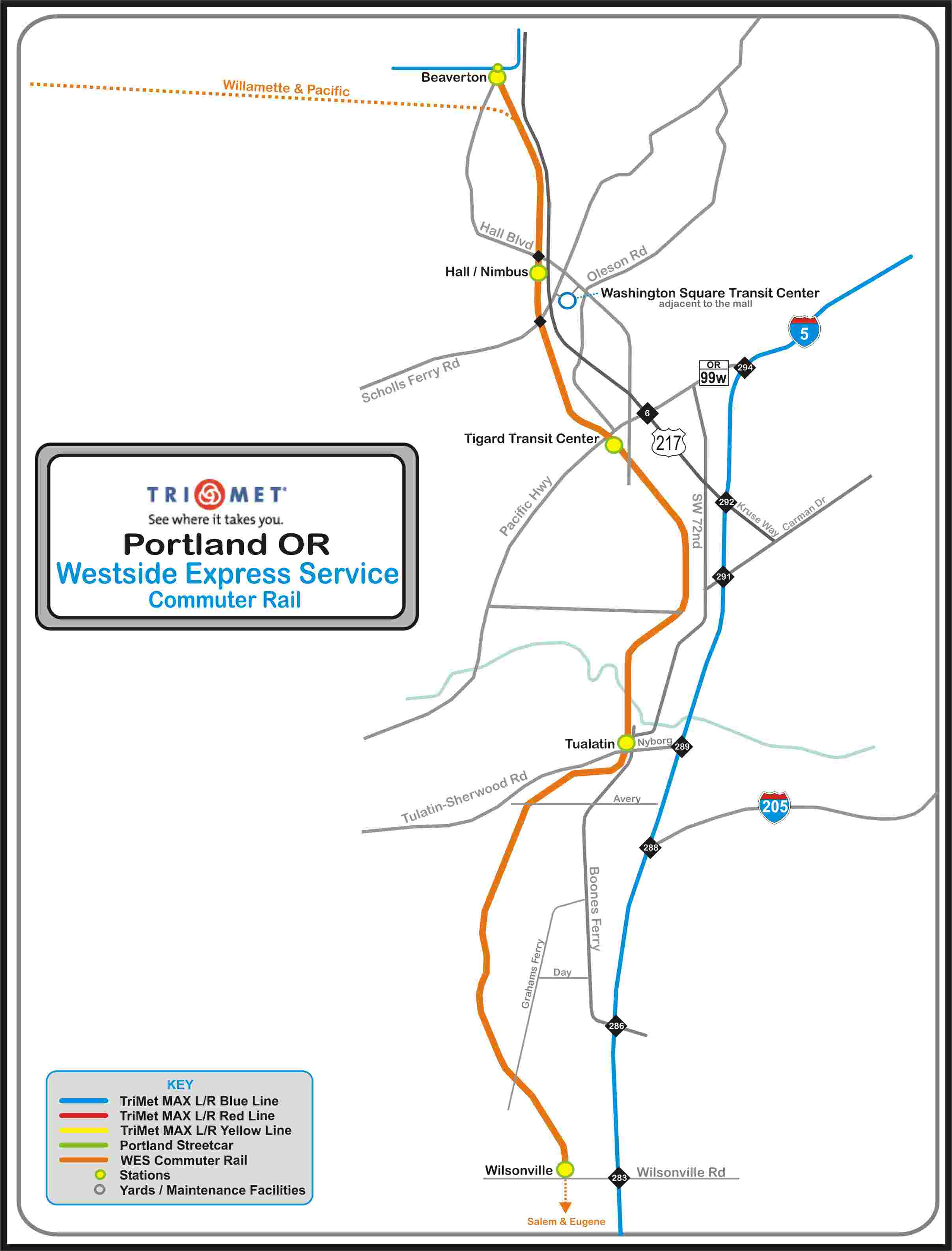
Map 3 ..... WES - the Westside Express Service Commuter Train
Map 4 ..... the Downtown Area
Map 5 ..... Light Rail West- Hillsboro to the tunnel
Map 6 ..... Light Rail East - Rose Quarter to Gateway
Map 7 ..... Light Rail - the Yellow Line - Rose Quarter to the Expo Center
Map 8 ..... Light Rail - the Red Line - Gateway to the Airport
Map 9 ..... Light Rail - the Blue Line - Gateway to Gresham
Map 10 ... Light Rail - the Green Line - Gateway to Clackamas
Map 11 ... Light Rail - the Orange Line - Downtown to SE Park
PENNSYLVANIA
Allentown & Bethlehem PA: Railfan Guide a guide by Nick Anshant & Dave Abeles
Altoona PA:
Altoona Railfan Guide Homepage
Altoona Proper
Altoona West - Pennsy Mainline Signal Guide
Altoona East to Mt Union - Pennsy Mainline Signal Guide
Mini-Railfan Guide a guide by Denver Todd
See below for Horseshoe Curve, Cresson and Gallitizin
Bridges and Viaducts:
Starrucca Viaduct - Lanesboro PA: Railfan Guide
Tuckhannock Viaduct -- Nicholson PA: Railfan Guide
Cassandra PA: Mini-Railfan Guide a guide by Denver Todd
Coatesville PA: Railfan Guide New Jan23
Columbia PA: Railfan Guide
Cresson PA:
Railfan Guide
Mini-Railfan Guide a guide by Denver Todd
Darby PA: Railfan Guide Railroad/Trolley crossing, one of 3 in the U.S.
Gallitzin PA:
Railfan Guide
Mini-Railfan Guide a guide by Denver Todd
Gallitzin/Cresson PA: the Allegheny Portage Railroad National Historic Site
Harrisburg PA:
Harrisburg Railfan Guide Homepage
Map 1 -- Downtown/Central Harrisburg
Harrisburg West to Macedonia - Pennsy Mainline Signal Guide
the Rockville Bridge
the Harris Tower Museum
Horseshoe Curve:
Railfan Guide Railfan Guide
Mini-Railfan Guide a guide by Denver Todd
Jenkintown PA (Philly suburb): Railfan Guide
Lancaster PA: Railfan Guide
Lanesboro PA: Railfan Guide
Langhorne PA: Part of the Yardley PA Railfan Guide
Lebanon PA: Railfan Guide
Lewistown PA: Railfan Guide
Manheim PA: Railfan Guide
Marysville PA - and the Rockville Bridge:
Railfan Guide
Mini-Railfan Guide a guide by Denver Todd
Morrisville PA: Railfan Guide
Mt Union PA:
Railfan Guide
Mt Union and East to Lewisburg - Pennsy Mainline Signal Guide
New Castle PA: Railfan Guide
New Freedom PA: Railfan Guide
New Freedom - the Northern Central RR: Railfan Guide
Nicholson PA: Railfan Guide for the Tuckhannock Viaduct
Nisbet (Williamsport) PA: Linden/South Linden/River Interlocking Signal Guide
North East PA:
The Lake Shore Railway Museum
Mini-Railfan Guide a guide by Denver Todd
Northumberland PA Railfan Guide
Orbisonia/Rockhill PA:
the East Broad Top RR Railfan Guide
the Rockhill Trolley Museum
Palmyra PA: Railfan Guide
Philadelphia PA Trains:
Philadelphia Railfan Guide Homepage
30th Street Station
ZOO Interlocking
Railroad History and Timeline
The Train Stations of 1934 Philadelphia
-- Northwest Philadelphia
-- Northeast Philadelphia
-- South Philadelphia
Streetcar/Train Crossing A page covering all three streetcar/train crossings in the U.S., including the one here in Darby, a suburb of Philadelphia
Towers in the Philadelphia area
Philadelphia PA SEPTA Transit:
SEPTA Homepage
Overall Rail System Maps
the Route 100 - Norristown LRV Line
the Route 101 and 102 Trolley Lines
the Subway Surface lines
the Trackless Trolley Lines
the Broad Street Subway Line
the Market-Frankford Subway Line
the Route 15 Trolley Line
the 69th Street Terminal
Darby Transportation Center
Darby Crossing A whole page dedicated to the infamous CSX/Streetcar crossing, not the same as the above page
Frankford Transportation Center
Norristown Transportation Center
Renaming the SEPTA Rail Lines
Pittsburgh PA: Light Rail Guide
Pittsburgh Line - Pennsy/PC/Conrail/Amtrak and now /NS
Altoona East: Railfan Guide a guide by RWK
West Slope: Railfan Timetable (Strip Map) (PDF) a guide by MJR
South Fork Secondary: Railfan Timetable (Strip Map) (PDF) a guide by MJR
South Fork Industrial Track: Railfan Timetable (Strip Map) (PDF) a guide by MJR
Lehigh Line East: Railfan Guide a guide by DTA
the Rockville Bridge - Marysville PA:
Railfan Guide
Mini-Railfan Guide a guide by Denver Todd
Scranton PA:
Railfan Guide
Steamtown National Historic Site
Starrucca Viaduct (Lanesboro PA): Railfan Guide
Stewartstown PA - the Stewartstown RR: Railfan Guide
Strasburg PA:
Railfan Guide
Railroad Museum of Pennsylvania
Sunbury PA: Railfan Guide
Susquehanna PA: Railfan Guide
Tuckhannock Viaduct (Nicholson PA): Railfan Guide
Woodbourne PA:
Railfan Guide
As part of the Yardley PA Railfan Guide
Yardley PA: Railfan Guide
York PA: Railfan Guide
PUERTO RICO
San Juan PR: Tren Urbano (Metro) Guide
RHODE ISLAND
Providence RI: Mini-Railfan Guide
SOUTH CAROLINA
Blacksburg SC:
Railfan Guide
NS's Blacksburg Yard Guide by Mike Falls
SOUTH DAKOTA
Sioux Falls SD: Railfan Guide
SPAIN
La Calahorra: Railfan Guide / Home to many "spaghetti westerns"
TENNESSEE
Chattanooga TN:
Railfan Guide
Chattanooga Choo-Choo..... It's not really a museum, but....
Erwin TN: Railfan Guide
Johnson City TN: Railfan Guide
Memphis TN: the Memphis Main Street Trolley
Nashville TN: Mini-Railfan Guide a guide by Denver Todd
NS's Rat Hole: Mini-Railfan Guide a guide by Denver Todd
TEXAS
Austin TX: Capital MetroRail Red Line Commuter System
Dallas TX:
DART Light Rail Map
Map 1 - Dallas Union Station area
Ft Worth TX:
Tower 55
TexRail
Flatonia TX:
Railfan Guide
Mini-Railfan Guide a guide by Denver Todd
Galveston TX: the Galveston RR Museum
Houston TX:
Houston Railfan Guide Homepage
Map 1 - Englewood Yard
Map 2 - Tower 85
Map 3 - Tower 87
Map 4 - Pierce Junction/Diamond
Map 5 - Downtown Houston
Map 6 - T&NO Junction
Map 7 - Casey Yard
Map 8 - Tower 13 and Eureka Yard
Map 9 - Belt Junction
Map 10 - GH&H Crossing
Map 11 - Gulf Coast Junction & Pierce Yard
Map 12 - Tower 26
Light Rail guide
Rosenburg TX: the Rosenburg RR Museum and Tower 17
Saginaw TX: Mini-Railfan Guide a guide by Denver Todd
Spring TX: Mini-Railfan Guide a guide by Denver Todd
Tyler TX (Tower 183): Railfan Guide
UNITED KINGDOM
Eurostar Service - London to Paris and Brussels
Isle of Wight: Island Line (subway)
UTAH
Salt Lake City UT:
-- UTA Light Rail System
-- UTA Green Line
-- UTA Red Line
-- UTA Blue Line
-- UTA S-Line Streetcar
-- RoadRunner Commuter Rail
Echo UT: Mini-Railfan Guide a guide by Denver Todd
Ogden UT: Mini-Railfan Guide a guide by Denver Todd
Soldier Summit UT: Mini-Railfan Guide a guide by Denver Todd
VERMONT
Burlington: Railfan Guide
the Green Mountain RR: Railfan Guide
Middlebury: Railfan Guide
St Albans: Railfan Guide
VIRGINIA
Virginia LOVE signs: Guide
Alexandria VA: Railfan Guide
Arlington VA - the Long Bridge: Railfan Guide
Ashland:
Railfan Guide
Mini-Railfan Guide a guide by Denver Todd
Bedford VA: Railfan Guide Home to the National D-Day Memorial, and an N&W station
Boyce and Berryville VA: Railfan Guide N&W PL Signals and depot
Charlottesville VA: Railfan Guide Depot and NS/CSX diamond
Christiansburg VA: Railfan Guide Two Depots
Clifton Forge VA: Mini-Railfan Guide a guide by Denver Todd
Doswell VA: Railfan Guide A diamond between the former RF&P and C&O Tower, and home to the Buckingham Branch RR
Emporia VA: Railfan Guide Depot and NS/CSX crossing
Ettrick VA: Railfan Guide Part of the Petersburg north guide - where the Petersburg Amtrak station is
Farmville VA: Railfan Guide Station and the Long Bridge
Fredericksburg VA: Railfan Guide Southern end of VRE operations
Lorton VA: Railfan Guide Northern terminus of Amtrak's Autotrain
Lynchburg VA: Mini-Railfan Guide a guide by Denver Todd
Manassas VA: Mini-Railfan Guide a guide by Denver Todd
Midlothian VA: Railfan Guide
Milford VA: Railfan Guide
Norfolk VA: the TIDE Light Rail Railfan Guide
Orange and Orange County VA: Railfan Guide
Petersburg VA
Railfan Guide North
Railfan Guide South - Mostly for Collier Yard
Richmond VA
Richmond Railfan Guide Homepage
Map 1 - Downtown Richmond - Main Street Station and the Triple Crossing
Map 2 - Acca Yard, AY, and the Amtrak Station
Map 3 - South Richmond - S Richmond Yard and the Old Dominion Rwy Museum
Map 4 - East Richmond - Sandston and the Airport
Roanoke/Salem VA:
Roanoke Railfan Guide Homepage
Map 1 - the South Side - JK Tower area guide
Map 2 - Downtown guide
Map 3 - the West Side guide - North Yard
Map 4 - Salem guide
Map 5 - Salem to Christiansburg Chase Map
Bedford VA Railfan Guide
Mini-Railfan Guide a guide by Denver Todd
Salem VA: Railfan Guide
Staunton VA: Railfan Guide
Suffolk VA: Railfan Guide
WASHINGTON
Auburn WA Mini-Railfan Guide a guide by Denver Todd
the Cascade Tunnel: Railfan Guide
the Columbia River Gorge: Mini-Railfan Guide a guide by Denver Todd
Seattle WA:
Link Light Rail Railfan Guide
Seattle Streetcar
Sounder Commuter Service
Tacoma WA: Mini-Railfan Guide a guide by Denver Todd
Vancouver WA:
Railfan Guide
Mini-Railfan Guide a guide by Denver Todd
WASHINGTON DC
DC Metro:
In General
the RED Line Guide
DC Streetcar: Railfan Guide
The Long Bridge: Railfan Guide
Suburban DC: Purple Line Railfan Guide
Transit in DC: Introduction Page
Washington DC:
Washington DC Railfan Guide Homepage
Virginia Ave Tower and Tunnel
Map 1 - Washington's Union Station
Map 2 - Ivy City Yard
Map 3 - Hyattsville and "JD Tower"
Map 6 - Northeast - the NEC from Bowie south to New Carrollton
Mini-Guide a guide by Denver Todd
WEST VIRGINIA
Harpers Ferry WV:
Railfan Guide
Mini-Railfan Guide a guide by Denver Todd
Harpers Ferry Bridge Guide a guide by Denver Todd
Romney WV: Potomac Eagle Scenic RR Railfan Guide
Sheperdstown WV: Railfan Guide
Thurmond WV: Mini-Railfan Guide a guide by Denver Todd
WISCONSIN
Hixton WI: Mini-Railfan Guide
Merrillan WI: Mini-Railfan Guide
Millston WI: Mini-Railfan Guide
Note: Don't get to excited about the above pages, no info, just great pictures
Alma WI: Mini-Railfan Guide a guide by Denver Todd
Byron WI: Mini-Railfan Guide a guide by Denver Todd
Duplainville Junction WI: Mini-Railfan Guide a guide by Denver Todd
La Crosse WI: Mini-Railfan Guide a guide by Denver Todd
Prarie Du Chien WI: Mini-Railfan Guide a guide by Denver Todd
Trempealeau WI: Mini-Railfan Guide a guide by Denver Todd
Tunnel City WI: Mini-Railfan Guide
Wyeville WI: Mini-Railfan Guide
WYOMING
Chyenne WY: Mini-Railfan Guide a guide by Denver Todd
Douglas WY: Mini-Railfan Guide a guide by Denver Todd
Sherman Hill WY: Mini-Railfan Guide a guide by Denver Todd
My Own Trips.....
TRIP 1 Sun 12APR2008 Aberdeen MD to Wilmington DE to chase B&O/CSX CPL's and Pennsy/Amtrak PL's
TRIP 2 Sat 18OCT2008 To Harrisburg and Northumberland to look for strange PL Signals
TRIP 3 Sat 12MAY2012 To New York City for National Train Day
TRIP 4
TRIP 5
TRIP 6 Mon/Tues 16JUN-17JUN2014 To New York City to see Dave Letterman
TRIP 7 Mon 7JUL2014 Wilmington DE to New York City via subways, light rail, and commuter systems instead of Amtrak
TRIP 8 Wed 13AUG2014 to Philadelphia PA to ride as much transit as we could!
TRIP 9 Sun 11OCT2015 I played passenger on an Amtrak train from Richmond VA to Baltimore MD, for a change.....
TRIP 10 Amtrak's Farewell Excursion to the AEM-7
TRIP 11 Mon 15AUG2016 to Philadelphia PA to catch NJT, MARC, and Amtrak leased trains running on SEPTA commuter lines
TRIP 12 Chasing down the remaining Pennsy PL signals on the Pittsburgh Line from Harrisburg to Lewistown PA
TRIP 13 Sun 11JUN2017 Chasing down the remaining Pennsy PL signals on the Pittsburgh Line from Huntingdon to Lewistown PA
TRIP 14 Wed 12JUL2017 Riding Streetcars in Philly Again
TRIP 15 22/23/24/25MAY2022 Trip to NYC, then to Savannah and back to Baltimore
TRIP 16 Wed 2JUN2022 Wilmington to Philly, Trenton, and Camden
Trips by Other Railfans
TRIP1 A trip by John Engleman to Australia during February and March 2016 by way of New Orleans LA, San Antonio TX, Los Angeles CA, and Hawaii
Most if not all junctions, or crossings of one railroad with another have some sort of protection so trains don't go banging into each other, below is a small sampling of what is out there that I have come across in my travels. A wide variety exists, although the protection is being more and more by plain old "darth vader" type color light signals.
As standard high type color lights become the norm for protection, older methods are become a rarer find, such as simples swing gates (Tyler TX), tilting targets, and even searchlight signals.
Some of the pages started out just to highlight the diamond, others are full blown railfan guides for the area that include a diamond crossing somewhere. The index page for this section used to have it's own page, but now, can only be found here!
Albert Lea MN......
Diamond Between the Union Pacific and the Iowa, Chicago, and Eastern
Baltimore MD.......
Pennsy and B&O (CSX/NS) crossing at Penn Mary Yard - Canton area
B&O crossing the Pennsy - Canton area
Deshler OH
CSX/CSX Diamond still plenty of CPL's around for the signal fan!
Doswell VA.....
CSX and CSX (ex C&O and RF&P)
Durand MI
GTW/GTW Diamond
Fostoria OH
CSX/NS/CSX Diamonds 3 cool diamonds!!!
Lansing MI
CSX and the GTW - Trowbridge Diamond
Mason City IA
2 UP Diamonds between the IC&E and Iowa Traction
Memphis TN
the Memphis Main Street Trolley One of four crossings between trolleys and trains
Merrillan WI
CNW and the GBW Big thanks to Jim!
Houston TX
Map 2 - Tower 85
Map 3 - Tower 87
Map 4 - Pierce Junction/Diamond
Tyler TX
Tower 183 Ex Cotton Belt and Missouri Pacific crossing (all UP now)
Allegheny Portage Railroad National Historic Site
B&O Railroad Museum Baltimore MD
Baltimore Streetcar Museum Baltimore MD
--7303 Restoration Guide
BSME - Baltimore Society of Model Engineers downtown Baltimore
Chattanooga Choo-Choo Chattanooga TN…. Not really a museum, but….
Coopersville & Marne Rwy Coopersville MI
Electric City Trolley Station & Museum Scranton PA, lots of signals!
Galveston RR Museum Galveston TX
Haley Tower Terre Haute IN
Harris Tower Museum Harrisburg
Lake Shore Railway Museum North East PA
Linden Railroad Museum Linden IN
Manheim Transportation Museum Manheim PA, just north of Lancaster
the Mid-Michigan Railroad Club Marshall MI:
Minnesota Streetcar Museum - Como Harriet Line Minneapolis MN
National Capitol Trolley Museum Colesville MD (suburban DC)
New York Museum of Transportation West Henrietta NY
North Carolina Transportation Museum Spencer NC
Radial Railway Museum Milton ONT
Railroad Museum of Pennsylvania Strasburg PA
Railroaders Museum Altoona PA
Rosenberg Railroad Museum Rosenberg TX, SW of Houston…. A signal fans must see
Steamtown Scranton PA
Tehachapi Depot Historical Museum Tehachapi CA
Western Maryland Rwy Historical Society Museum Union Bridge MD
Western New York Railway Society Museum dedicated to the Lehigh Valley RR in the former LV Williamsville NY Depot
TRANSIT and COMMUTER RAIL SYSTEMS
I have consolidated my individual index pages for Light Rail Systems and Heavy Rail/Metro Systems onto this one page, and added commuter Rail - it makes maintenance a little easier :-). These pages were originally conceived to highlight the various signal systems used on transit systems, but many have developed into Railfan Guides in their own right.Transit signals are quickly becoming the only place in railroading where you can find variety. All the way from the simple LED bar signals of Houston, to the overdone signals of the Minneapolis system, with their heavy duty heavy rail style color position lights. In between, you can find almost anything.
With commuter railroads, the majority of them are guests on a host railroad, and they do not have signals per se of their own...... SEPTA in Philadelphia is one of the exceptions, where they took over the commuter rail operations of the Reading and the Pennsylvania railroads, and freight traffic runs pretty much on their own and separate tracks.
If you have anything to add, correct, or contribute, please email me here. You CAN make a difference as can be seen with the railfan guide to Newark NJ, where ALL of the info came from one "anonymous donor".
Atlanta GA: MARTA Metro System guide
Austin TX: Capital MetroRail Red Line Commuter System
Baltimore MD:
Baltimore MTA Light Rail Guide
MTA Light Rail & Metro Subway map
the Light Rail System
the Metro Subway System
Boston MA:
MBTA Light & Heavy Rail (just maps so far)
the Mattapan High Speed Trolley Line
Buffalo NY: Light Rail guide
Camden NJ:
NJT's River Line Light Rail
PATCO High Speed Line
Charlotte NC: Light Rail Guide
Chicago IL:
Metra Commuter Rail (map and basic info only)
CTA El and Subway System (map and basic info only)
Cincinnati OH: Cincinnati Streetcar: Railfan Guide
Dallas TX: DART Light Rail Map
Denver CO: RTD Light Rail System Guide
Grenoble FR: TAG Light Rail Guide
Houston TX: Light Rail guide
Los Angeles CA:
Transit Home
MTA Light Rail System
Memphis TN:
the Memphis Main Street Trolley
Minneapolis MN:
Hiawatha Light Rail Guide
Northstar Commuter Service
Newark NJ: Newark Subway Light Rail guide
New Orleans LA: Streetcar Guide
New York NY:
PATH Rail System
SIRT Railfan Guide
Norfolk VA: the TIDE Light Rail Railfan Guide
Ottawa ON:
O-Train Trillium Light Rail Transit Service
O-Train Confederation Light Rail Transit Service
Philadelphia PA: SEPTA Homepage
Pittsburgh PA: PAT Light Rail Guide
Portland OR: Portland OR maps
Salt Lake City UT: UTA Light Rail System
San Diego CA: MTS San Diego Trolley
San Francisco CA: CalTrain
San Jose CA:
VTA Light Rail System Guide
ACE - Altamont Commuter Express
San Juan PR: Tren Urbano (Metro) Guide
Seattle WA:
Link Light Rail Railfan Guide
Seattle Streetcar
Sounder Commuter Service
St Louis MO: Metro Light Rail System Map
Suburban MD/DC: Purple Line Railfan Guide
Toronto ON: TTC Streetcar Guide
Tucson AZ: Tucson's Sunlink Light Rail System Railfan Guide
Vancouver BC:
Skytrain Railfan Guide
West Coast Express Railfan Guide
Washington DC:
WMATA's Metro system Railfan Guide
the RED Line Guide
the DC Streetcar
Baltimore MD
the MTA Light Rail System (For now, details of the system are on each sections' map)
the Red Line (This and that on the system that got nixed in June 2015)
the Purple Line (Construction start in 2016, maybe)
Boston MA
MBTA Light Rail (just maps so far)
the Mattapan High Speed Trolley Line (station by station guide)
Buffalo NY
NFTA Light Rail System
Camden/Trenton NJ
NJT's River Line Light Rail
Charlotte NC
LYNX's Blue Line Light Rail System
Cincinnati OH
Cincinnati Streetcar:Railfan Guide
Cleveland OH
RTA Light and Heavy Rail Systems
Dallas TX
DART Light Rail Map
Denver CO
RTD Light Rail System (station by station guide)
Grenoble FR:
TAG Light Rail Guide
Houston TX
Metro Light Rail System
Los Angeles CA
Transit Home
MTA Light Rail System
Minneapolis MN
Hiawatha Light Rail System (station by station guide)
Newark NJ
NJT's Newark Subway Light Rail System (this map is a railfan guide for the area, and includes the railroads)
New Orleans LA
Streetcar Guide (OK, so it's not Light Rail)
Norfolk VA
the Tide Light Rail System (station by station guide)
Ottawa ON
O-Train Trillium Light Rail Transit Service
O-Train Confederation Light Rail Transit Service
Philadelphia PA
SEPTA Homepage
SEPTA Route 100 - Norristown LRV Line
SEPTA Route 101 and 102 Trolley Lines
SEPTA Subway Surface lines (trolleys)
SEPTA's 69th Street Terminal
SEPTA's Darby Transportation Center
SEPTA's Frankford Transportation Center
SEPTA's Norristown Transportation Center
Pittsburgh PA
PAT Light Rail System
Portland OR
Tri-Met MAX Light Rail (some maps, some guides)
Salt Lake City UT
UTA Light Rail System (maps by UTA only)(real basic info)
San Diego CA
MTS San Diego Trolley (real basic info)
San Francisco CA
Cable Cars
Vintage Streetcars
Trackless Trolleys (Trolley Busses)
San Jose CA
VTA Light Rail System
Seattle WA
Link Light Rail System Guide
St Louis MO
Metro Light Rail System Map
Toronto ON
TTC Streetcars
Tucson AZ
Tucson's Sunlink Light Rail System Railfan Guide
Washington DC
the DC Streetcar
Purple Line Railfan Guide
Atlanta GA
MARTA Metro System guide
Baltimore MD
the Baltimore Metro Subway System
Boston MA
MBTA Heavy Rail (just maps so far)
Camden (& Philly) to Lindenwold NJ
PATCO High Speed Line
Chicago IL
CTA El and Subway
Cleveland OH
RTA Heavy Rail
Los Angeles CA
Transit Home
MTA Heavy Rail System
Miami FL
Metrorail System
New York City NY
MTA Subway System
SIRT Railfan Guide
New York/New Jersey
PATH Rail System
Philadelphia PA
SEPTA Homepage
SEPTA Overall Rail System Map
SEPTA Broad Street Subway Line
SEPTA Market-Frankford Subway Line
SEPTA's 69th Street Terminal
SEPTA's Frankford Transportation Center
San Francisco
BART - Bay Area Rapid Transit
Cable Cars
San Juan PR
Tren Urbano Metro System
Toronto ON
TTC Metro (Map only so far as part of the Streetcar page)
Vancouver BC
SkyTrain Railfan Guide
Washington DC
WMATA Metro
Albuquerque NM
New Mexico Rail Runner Express
Amtrak
Amtrak's "New" Hudson River Tunnel
Austin
Capital MetroRail Red Line Commuter System
Baltimore and Maryland
MARC Chase Guides:
Brunswick Line
Camden Line
Penn Line North
Penn Line South
Boston MA
MBTA - Massachusetts Bay Transportation Authority
Chicago IL
Metra
Dallas TX to Ft Worth
TRE - Trinity Rail Express
Denton TX
DCTA - Denton County Transportation Authority
Ft Worth TX to DFW Airport
TexRail
Los Angeles CA
Transit Home
Metrolink
Miami FL
Tri-Rail
Minneapolis MN
Northstar Commuter Service
Montreal QB
AMT - Agence Metropolitaine de Transport
Nashville TN
Music City Star
New Haven CT to New London
Shore Line East
New Jersey
NJT - New Jersey Transit
New York City NY / Long Island
LIRR - Long Island RR
New York City NY and North
Metro North
NOVA - Northern Virginia
VRE - Virginia Rail Express
Philadelphia PA
SEPTA Homepage
SEPTA Rail System Map
30th Street Station
ZOO Interlocking
Portland OR
WES - Westside Express Service Map Only
Salt Lake City UT to Ogden
FrontRunner
San Diego CA to Oceanside
Coaster
San Francisco CA to San Jose
CalTrain
San Jose CA to Stockton
ACE - Altamont Commuter Express
Seattle WA to Tacoma
Sounder Commuter Rail
South Bend IN - Chicago IL
South Shore / NICTD
Toronto ON
GO Transit
Vancouver BC
West Coast Express
Sometime in 2013, I started putting the histories of some of the railroads, as long as it doesn't take up a book as it would with the Pennsy or Union Pacific, on the pages the history would affect. Along with this, I usually put a number of excerpts of vintage USGS maps on those pages too, because I "came across" a most excellent resource for them at the University of Texas website.
This is an index to places where I have histories of the railroads, or sometimes the towns they go thru. The links are to the page the history appears on.
the "Big Four Railroad"
the Cincinnati, Indianapolis, St Louis & Chicago Rwy (short history/milestones only)
the Cleveland, Cincinnati, Chicago, and St Louis RR (CCC&StL)
the Cleveland, Columbus, Cincinnati, & Indianapolis Rwy (CCC&I) (short history/milestones only)
the Fort Dodge, Des Moines & Southern Rwy
the Hocking Valley Rwy
the Indiana, Bloomington & Western Rwy (short history/milestones only)
New York City: the Staten Island Rapid Transit
It is impossible for me to list all of the other railfan guides individually, mainly because there are way too many, AND, many go as quickly as they come, therefore, this list is comprised mostly of other lists of guides. As far as the individual railfan pages go, beware, there are a number of dead links, and there are a larger number of websites that have not been updated for years, sometimes as much as ten years!
https://www.railfanguides/us/gregarious/ Denver Todd's railfan pages, now hosted "here"
http://railfanlocations.weebly.com/ Details around 30 or so railfan "hotspots"
http://www.railserve.com/ This is their homepage
http://www.railserve.com/Railfan_Guides/ This is Railserve's index page to the different areas of the USA
http://www.railserve.com/Railfan_Guides/Northeast/ This page has links to railfan guides along the east coast to say, Michigan and Ohio
http://www.railserve.com/Passenger/North_America/ Links to passenger trains in the USA
http://www.railserve.com/Lodging_Restaurants/ Their list of railfan oriented restaurants and lodging
http://www.spikesys.com/Interchg/ This is the Webville and Hypertext's index page to lists of everything, altho it doesn't look like it's been updated lately
http://www.frograil.com/railroad/locations.php Text based guides for most everywhere
http://www.parailfan.com/Guides/Altoona_East/altoonaeast_home.html Covers the Altoona area
If you have any comments, contributions, additions, questions, whatever.......... http://www.railroadsignals.us/contact.htm
Free web counter provided by http://statcounter.com/
new 6/24/2008